more stats
3,953 ft
Distance
-885 ft
Descent
00:20:54
Avg time
-885 ft
Altitude change
3,444 ft
Altitude min
4,330 ft
Altitude max
4,330 ft
Altitude start
3,445 ft
Altitude end
-22.4%
Grade
-89%
Grade max
-0.4%
Grade min
26 ft
Distance climb
3,845 ft
Distance down
82 ft
Distance flat
00:20:54
Avg time

Boradora Details

  • Activities
    • Mountain Bike
    • E-Bike
    • Hike
    • Trail Running
  • Riding Area
    Sgreben Zone
    Baselga di Pine'
  • Difficulty Rating
  • Local Popularity
    70 in Mountain Biking [+]
    • 65 in E-Biking
    • 100 in Trail Running
    • 5 in Hiking
  • Global Ranking
    #81549 in Mountain Biking [+]
    • #63873 in E-Biking
    • #22560 in Trail Running
    • #140520 in Hiking
  • Trail Exposure
    High Risk
  • Trail Type
    Singletrack
  • Bike Type
    DH, AM
  • eBike Allowed
    Yes up to Class 1
  • TTFs on Trail
    Drop, Rock Garden

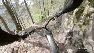
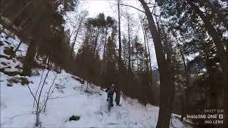
Trail che si può considerare completo dal punto di vista tecnico. Nel primo tratto si ha una diminuzione della pendenza con un traverso da pedalare. Verso metà inizia ad essere un po' roccioso con anche una serie di tornanti tecnici. L'ultimo tratto, sotto l'ultima forestale è ad altissima velocità su una vecchia mulattiera.

This trail is unsanctioned.

Disclaimer

Multi-use natural trail, ride at own risk. | Sentiero naturale multi-uso, utilizzare a proprio rischio.

Recent Activity on Trail

Past Week
  • 0 rides
  •  
6 Months
  • 3 rides
  • 18 miles avg distance
All
  • 15 rides
  • Last: Apr 4, 2026
c1c2c3c4
January
February
March
April
May
June
July
August
September
October
November
December
update trails status or condition

Boradora Trail Reports

statusdatedescription
Jun 3, 2026 @ 10:10am (Europe/Vaduz)
Jun 3, 2026
reporter
Apr 4, 2026 @ 4:29pm (Europe/Rome)
Apr 4, 2026
Some loose rocks and branches, but nothing major. Good condition overall
Mar 23, 2026 @ 6:44pm (Europe/Rome)
Mar 23, 2026
reporter
Completamente soffiato
Mar 20, 2026 @ 11:33am (Europe/Rome)
Mar 20, 2026
reporter Fogliame come da stagione
Jan 2, 2026 @ 10:12am (Europe/Vaduz)
Jan 2, 2026
reporter Fogliame come da stagione, attenzione appena prima dei due tornanti che le piante stanno marcendo e potrebbero cadere nel trail
more »
Status:
on Jun 3, 2026
Ideal
Avg: 4.26 (6 votes)
Your vote: 0

view (40)
close
3D
Trail Conditions
  • Unknown
  • Snow Groomed
  • Snow Packed
  • Snow Covered
  • Snow Cover Partial
  • Freeze/thaw Cycle
  • Icy
  • Prevalent Mud
  • Wet
  • Variable
  • Ideal
  • Dry
  • Very Dry
Trail Flow (Ridden Direction)
Trailforks scans users ridelogs to determine the most popular direction each trail is ridden. A good flowing trail network will have most trails flowing in a single direction according to their intension.
The colour categories are based on what percentage of riders are riding a trail in its intended direction.
  • > 96%
  • > 90%
  • > 80%
  • > 70%
  • > 50%
  • < 50%
  • bi-directional trail
  • no data
Trail Last Ridden
Trailforks scans ridelogs to determine the last time a trail was ridden.
  • < 2 days
  • < 1 week
  • < 2 weeks
  • < 1 month
  • < 6 months
  • > 6 months
Trail Ridden Direction
The intended direction a trail should be ridden.
  • Downhill Only
  • Downhill Primary
  • Both Directions
  • Uphill Primary
  • Uphill Only
  • One Direction
Contribute Details
Colors indicate trail is missing specified detail.
  • Description
  • Photos
  • Description & Photos
  • Videos
Trail Popularity ?
Trailforks scans ridelogs to determine which trails are ridden the most in the last 9 months. Trails are compared with nearby trails in the same city region with a possible 25 colour shades. Think of this as a heatmap, more rides = more kinetic energy = warmer colors.
  • most popular
  • popular
  • less popular
  • not popular
ATV/ORV/OHV Filter
Max Vehicle Width
inches
US Cell Coverage
Legend
cell carrier legend

Radar Time
Activity Recordings
Trailforks uses anonymized public activity data. ?
Activity Recordings
Trailforks uses anonymized public activity data. ?
Personal Heatmap
Activity Types
all / none
Options
2
Date range month
Winter Trails
Warning A routing network for winter maps does not exist. Selecting trails using the winter trails layer has been disabled.
Missing Trails
Most Popular
Least Popular
Trails are colored based on popularity. The more popular a trail is, the more red. Less popular trails trend towards green.
Jump Magnitude Heatmap
Heatmap of where riders jump on trails. Zoom in to see individual jumps, click circles to view jump details.
BC Backroad Status

Service Road Atlas is a free to use, community-driven service for viewing and creating reports on the numerous back-country service roads around B.C. and Alberta.

map legend
Slope Aspect
Direction the slope faces
Flat N NE E SE S SW W NW
Trails Deemphasized
Trails are shown in grey.
disable
Only show trails with no bike usage.
Enable
Suggested Layers
Based on selected activity type

    Save the current map location and zoom level as your default home location whenever this page is loaded.

    Save
        Directions to boradora trailhead (46.161560, 11.277020)

        Photos

        10 more »
        38 |
        May 23, 2025 @ 12:03pm
        May 23, 2025
        31 |
        May 23, 2025 @ 12:03pm
        May 23, 2025
        23 |
        May 23, 2025 @ 12:03pm
        May 23, 2025
        77 |
        Jun 20, 2020 @ 4:27am
        Jun 20, 2020

        Videos

        2 more »
        sentiero MTB Boradora completa tre segmenti ex...
        4:51 | 162 | May 12, 2024 , Baselga di Pine'
        Trail BORADORA innevata slipperi slipperi...
        4:46 | 113 | Dec 23, 2022 , Baselga di Pine'

        Trail Lists

        2 Reviews & Comments


        We hope you've been enjoying Trailforks!

        Create a FREE account to view trail comments and much more.

        • #299455 - 1,026 views

        Frequently Asked Questions About Boradora

        Where is Boradora located?
        Boradora is located in Sgreben Zone, Baselga di Pine', Italy. It is part of the Sgreben Zone trail network. The trailhead is located at coordinates 46.16156, 11.27702.
        How hard is Boradora?
        Boradora is rated as Red difficulty. The average grade is 22.4%.
        What is the elevation gain for Boradora?
        The trail has 270 m of elevation descent. The elevation ranges from 1,050 m to 1,320 m.
        How long is Boradora?
        Boradora is 1.2 km long. The trail type is singletrack.

        Hit the Trail

        Open in App

        Get this trail on your phone instantly.
        open trail in app

        Download Trail

        Save to wishlist, Garmin & download.
        save the trail

        Find Related Routes

        Find routes and users activities that include this trail.
        find routes for this trail

        You must enter a description before submitting.