
Open in App
Get this trail on your phone instantly.

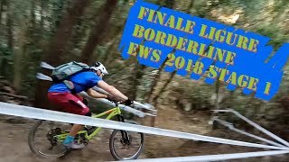
Stage 1 of the EWS in 2018, and built from scratch, it features and extremely high historical interest. Thanks to the trail used to reach the top, the track goes alongside some primitive remains of flat rock being carved for collecting water.
Being in San Bernardino, it shows a classic style of tight, steep corners, red soil, thick forest and magical environment.
San Bernardino Area is reachable from the E80 highway accessing Finale Ligure, drive towards the sea cross the bridge on Via XXV Aprile.
Given its nature, the trail can change after weather happenings and season changes. Always pay attention.
| c1 | c2 | c3 | c4 |
|---|---|---|---|
January | February | March | April |
May | June | July | August |
September | October | November | December |

Service Road Atlas is a free to use, community-driven service for viewing and creating reports on the numerous back-country service roads around B.C. and Alberta.
Save the current map location and zoom level as your default home location whenever this page is loaded.
SaveWe hope you've been enjoying Trailforks!
Create a FREE account to view trail comments and much more.
You must enter a description before submitting.

