


 Rock Face
Open in App
Get this trail on your phone instantly.

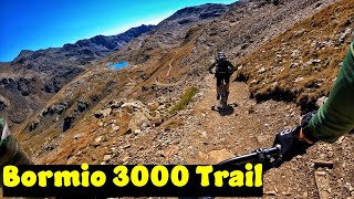
One of those MUST-DO-Trails with an amazing landscape and a very long descent ride
In the first part from top to the lakes, more or less you only ride on a track which is full of easy and flat rocks. But not that technical to ride – just surf on/through the loose rocks (difficulty: between blue and black). There are also a few short uphills in this section. After the lakes it is a nice and flowy track with some flat blocked sections (but not that hard to ride), and one short but quite techy section (S2-S3). Most of the track-difficulty is green to blue in this long section. Some very fast sections.
Last part is a singletrack-uphill to the trail-entry of "Le Cune"-Trail – maybe you have to walk/push your bike in this section.
Please do not forget, that you ride at high-alpine terrain and that there are various risks and possible dangers in this area in case of a crash, accident, bad-weather (...).
Take care of hikers – there could be also lots of hikers on this track!
Wearing a helmet is compulsory. Be friendly to hikers. Ride at your own risk.
| c1 | c2 | c3 | c4 |
|---|---|---|---|
January | February | March | April |
May | June | July | August |
September | October | November | December |

Service Road Atlas is a free to use, community-driven service for viewing and creating reports on the numerous back-country service roads around B.C. and Alberta.
Save the current map location and zoom level as your default home location whenever this page is loaded.
SaveWe hope you've been enjoying Trailforks!
Create a FREE account to view trail comments and much more.
You must enter a description before submitting.

