more stats
1.4 miles
Distance
-1,213 ft
Descent
1 mile
High Point
-1,213 ft
Altitude change
4,686 ft
Altitude min
5,899 ft
Altitude start
4,685 ft
Altitude end
-16.3%
Grade
-90.3%
Grade max
0.5%
Grade min
1 mile
Distance down
30 ft
Distance flat

Bosc de Junyent Details

  • Activities
    • Mountain Bike
    • Hike
    • Trail Running
  • Riding Area
  • Difficulty Rating
  • Local Popularity
    5 in Mountain Biking [+]
    • 5 in Trail Running
    • 5 in Hiking
  • Global Ranking
    #278991 in Mountain Biking [+]
    • #169255 in Trail Running
    • #164361 in Hiking
  • Trail Type
    Singletrack
  • Direction
    Both Directions
  • Climb Difficulty
    Black Diamond
  • Trail Visibility
    Always easy to follow
  • Dogs Allowed
    Yes

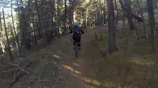
Antiga pista de desbrossar reconvertida a sender. Algun tram brut de branques però es passa bé. Pertany al Camí Vell de les Valls d'Aguilar (volta senderista a la vall; compte amb els excursionistes). El 99% és verda; algun passet blau.

Recent Activity on Trail

Past Week
  • 0 rides
  •  
6 Months
  • 0 rides
  •  
All
  • 0 rides
  •  
update trails status or condition

Bosc de Junyent Trail Reports

statusdatedescription
Jun 20, 2026 @ 5:35pm (Europe/Madrid)
2 days
Les ventades han tombat molts arbres al mig de la traça. Ja n'hem retirat bastants, però encara en queden alguns per treure.
Jun 21, 2025 @ 10:16am
Jun 21, 2025
Algun tram brutot (pinyes, branques, etc), però res significatiu. Continua fàcil.
Mar 1, 2025 @ 1:30am
Mar 1, 2025
És el que aguanta millor de la zona: està humit, com la resta d'obacs de la zona, però es deixa fer sense problema. Una mica de neu a la part alta.
May 28, 2023 @ 10:25am
May 28, 2023
Sep 5, 2022 @ 11:01am
Sep 5, 2022
Està perfecta. Algú ha netejat (suposo que la gent de la CVVA) unes parts pedregoses del final i han tret unes branques que sortien una mica.
more »
Status:
on Jun 20, 2026
Variable
no votes yet
Your vote: 0

view (2)
close
3D
Trail Conditions
  • Unknown
  • Snow Groomed
  • Snow Packed
  • Snow Covered
  • Snow Cover Partial
  • Freeze/thaw Cycle
  • Icy
  • Prevalent Mud
  • Wet
  • Variable
  • Ideal
  • Dry
  • Very Dry
Trail Flow (Ridden Direction)
Trailforks scans users ridelogs to determine the most popular direction each trail is ridden. A good flowing trail network will have most trails flowing in a single direction according to their intension.
The colour categories are based on what percentage of riders are riding a trail in its intended direction.
  • > 96%
  • > 90%
  • > 80%
  • > 70%
  • > 50%
  • < 50%
  • bi-directional trail
  • no data
Trail Last Ridden
Trailforks scans ridelogs to determine the last time a trail was ridden.
  • < 2 days
  • < 1 week
  • < 2 weeks
  • < 1 month
  • < 6 months
  • > 6 months
Trail Ridden Direction
The intended direction a trail should be ridden.
  • Downhill Only
  • Downhill Primary
  • Both Directions
  • Uphill Primary
  • Uphill Only
  • One Direction
Contribute Details
Colors indicate trail is missing specified detail.
  • Description
  • Photos
  • Description & Photos
  • Videos
Trail Popularity ?
Trailforks scans ridelogs to determine which trails are ridden the most in the last 9 months. Trails are compared with nearby trails in the same city region with a possible 25 colour shades. Think of this as a heatmap, more rides = more kinetic energy = warmer colors.
  • most popular
  • popular
  • less popular
  • not popular
ATV/ORV/OHV Filter
Max Vehicle Width
inches
US Cell Coverage
Legend
cell carrier legend

Radar Time
Activity Recordings
Trailforks uses anonymized public activity data. ?
Activity Recordings
Trailforks uses anonymized public activity data. ?
Personal Heatmap
Activity Types
all / none
Options
2
Date range month
Winter Trails
Warning A routing network for winter maps does not exist. Selecting trails using the winter trails layer has been disabled.
Missing Trails
Most Popular
Least Popular
Trails are colored based on popularity. The more popular a trail is, the more red. Less popular trails trend towards green.
Jump Magnitude Heatmap
Heatmap of where riders jump on trails. Zoom in to see individual jumps, click circles to view jump details.
BC Backroad Status

Service Road Atlas is a free to use, community-driven service for viewing and creating reports on the numerous back-country service roads around B.C. and Alberta.

map legend
Slope Aspect
Direction the slope faces
Flat N NE E SE S SW W NW
Trails Deemphasized
Trails are shown in grey.
disable
Only show trails with no bike usage.
Enable
Suggested Layers
Based on selected activity type

    Save the current map location and zoom level as your default home location whenever this page is loaded.

    Save
        Directions to bosc-de-junyent trailhead (42.321400, 1.190170)

        Photos

        7 more »
        34 |
        Jul 16, 2024 @ 10:03am
        Jul 16, 2024
        51 |
        Jul 16, 2024 @ 10:03am
        Jul 16, 2024
        38 |
        May 28, 2023 @ 10:21am
        May 28, 2023
        42 |
        May 28, 2023 @ 10:20am
        May 28, 2023

        Videos

        1 more »
        Bosc de Junyent
        4:55 | 116 | Nov 13, 2022 , la Seu d'Urgell

        Reviews / Comments

        No reviews yet, be the first to write a review or ask a question.
        Use trail reports to comment on trail conditions.


        We hope you've been enjoying Trailforks!

        Create a FREE account to view trail comments and much more.

        • By passamuntanyes & contributors
        • #425491 - 465 views

        Frequently Asked Questions About Bosc de Junyent

        Where is Bosc de Junyent located?
        Bosc de Junyent is located in la Seu d'Urgell, Spain. It is part of the la Seu d'Urgell trail network. The trailhead is located at coordinates 42.3214, 1.19017.
        How hard is Bosc de Junyent?
        Bosc de Junyent is rated as Green difficulty. The average grade is 16.3%. The climb difficulty is rated Black Diamond.
        What is the elevation gain for Bosc de Junyent?
        The trail has 370 m of elevation descent. The elevation ranges from 1,428 m to 1,798 m.
        Is Bosc de Junyent a point to point trail?
        Bosc de Junyent is not a point to point trail. The direction is Both Directions. The trail type is singletrack.

        Hit the Trail

        Open in App

        Get this trail on your phone instantly.
        open trail in app

        Download Trail

        Save to wishlist, Garmin & download.
        save the trail

        Find Related Routes

        Find routes and users activities that include this trail.
        find routes for this trail

        You must enter a description before submitting.