more stats
5.2 miles
Distance
425 ft
Climb
-3,517 ft
Descent
01:13:54
Avg time
-3,092 ft
Altitude change
9,550 ft
Altitude min
13,054 ft
Altitude max
12,642 ft
Altitude start
9,551 ft
Altitude end
-11.2%
Grade
-74%
Grade max
78.5%
Grade min
3,301 ft
Distance climb
4 miles
Distance down
774 ft
Distance flat
01:13:54
Avg time

Boulder Gulch Details

  • Activities
    • Hike
    • Mountain Bike
    • Trail Running
  • Riding Area
    Silverton
    , Colorado
  • Difficulty Rating
  • Local Popularity
    60 in Mountain Biking [+]
    • 5 in Trail Running
    • 5 in Hiking
  • Global Ranking
    #74687 in Mountain Biking [+]
    • #137153 in Trail Running
    • #131137 in Hiking
  • Hiking SAC Scale
    T1 Hiking
  • Trail Type
    Primitive
  • Bike Type
    AM
  • Direction
    Downhill Primary
    Popular Direction Shown
  • Climb Difficulty
    Double Black Diamond
  • Physical Rating
    Extreme
  • Trail Visibility
    Sometimes hard to follow
  • Season
    July - Sept
  • Alpine Trail
    Yes
  • Dogs Allowed
    Yes
  • eBike Allowed
  • TTFs on Trail
    Rock Garden

This is more than a ride. It’s an alpine adventure that you won’t forget. After a 2,000’ hike-a-bike, you’ll crest the ridge and be treated to spectacular views. Boulder Gulch trail is very steep and descends 3,700’ in less than four miles and has a variety of riding (alpine tundra, exposed side hilling, rocky technical fun, and many very steep, loose sections). This is a hardcore alpine experience and you must be fully prepared (be prepared for remoteness, wind, cool temps, and lightning likely during thunderstorms). There is very limited cell service on this route.

From Silverton, take county road 110 past the Silverton ski area. The road will eventually curve right, past the Water Treatment Plant. From here, take County Road 52 to the end (Velocity Basin). Park here and get ready to hike your bike.

From the parking area, there is a trail that heads east. Bikes are not allowed to be ridden anywhere on the climb and must be carried. With your bike on your back, follow this trail. Your objective is the ridgeline above. After ascending 2,000 ft, you’ll reach the ridge where you’ll find a faint trail. Follow this trail along the ridge until you eventually reach the high point at 13,000’. Stop and enjoy the views (you’ll look down into Eureka Gulch to your left, Velocity Basin to your right, and Boulder Gulch straight ahead).

From the high point, get ready for a spicy descent (the trail descends 3,700’ in approx. 3.5 miles). The trail is very faint at the top but becomes more pronounced as you go further down. If you lose the trail at the top, stop and look for cairns.

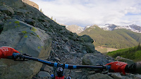
The initial trail is faint as it descends through the alpine tundra. There are some sections where the trail skirts along the side of steep hillsides. About midway down, the trail jogs left and over a small creek crossing. Continue following the trail as it passes through the trees. There are several sharp switchbacks sprinkled throughout, and some super steep sections of loose rock. Eventually the trail ends at Boulder Gulch stream where you’ll see a concrete intake pond. This is Silverton’s water source so please stay out of the water. From here, follow the doubletrack road which eventually leads to Silverton. Stay on the doublectrack road and do not shortcut through private property to reach CR2

Access Info Restricted Access

The primary route to get to this trail begins at Velocity Basin. Bikes are not allowed to be ridden on the climb (BLM land from the lake to the summit); however, you are allowed to hike this section with your bike on your back. The roughly 2,000 ft. climb is steep and most people wouldn’t be able to ride it anyway.

Be prepared for weather because this area attracts a lot of lightning. The high point is 13,000 ft and weather conditions can change in minutes. The trail is steep the whole way down so be sure your brakes are in good working order

At the end of the ride (bottom of the trail), be sure to stay on the doubletrack road until you reach the gate at the water tank. Stay on the doublectrack road and do not shortcut through private property to reach CR2!

Disclaimer

This is a hardcore high alpine adventure ride. Not to be taken lightly because of the remoteness, elevation, and exposure to lightning. If it looks like dark clouds are moving in, get down as lightning strikes are very common up here.

Trail Supporters
  • BLM
    BLM
    Land Manager
Local Trail Association
Traditionally Indigenous Territory

Recent Activity on Trail

Past Week
  • 0 rides
  •  
6 Months
  • 0 rides
  •  
All
  • 8 rides
  • Last: Jun 22, 2026
c1c2c3c4
January
February
March
April
May
June
July
August
September
October
November
December
update trails status or condition

Boulder Gulch Trail Reports

statusdatedescription
Jul 17, 2025 @ 7:45am
Jul 17, 2025
Oct 19, 2024 @ 9:07am
Oct 19, 2024
Snow covered for season.
Oct 19, 2024 @ 9:06am
Oct 19, 2024
Snow covered for season.
Aug 27, 2024 @ 7:00am
Aug 27, 2024
Jun 23, 2024 @ 12:41pm
Jun 23, 2024
6 snow fields up high (2 very large) and 2 down trees down low of unknown size.
more »
Status:
on Jul 17, 2025
Ideal
Avg: 4.17 (5 votes)
Your vote: 0

view (139)
close
3D
Trail Conditions
  • Unknown
  • Snow Groomed
  • Snow Packed
  • Snow Covered
  • Snow Cover Partial
  • Freeze/thaw Cycle
  • Icy
  • Prevalent Mud
  • Wet
  • Variable
  • Ideal
  • Dry
  • Very Dry
Trail Flow (Ridden Direction)
Trailforks scans users ridelogs to determine the most popular direction each trail is ridden. A good flowing trail network will have most trails flowing in a single direction according to their intension.
The colour categories are based on what percentage of riders are riding a trail in its intended direction.
  • > 96%
  • > 90%
  • > 80%
  • > 70%
  • > 50%
  • < 50%
  • bi-directional trail
  • no data
Trail Last Ridden
Trailforks scans ridelogs to determine the last time a trail was ridden.
  • < 2 days
  • < 1 week
  • < 2 weeks
  • < 1 month
  • < 6 months
  • > 6 months
Trail Ridden Direction
The intended direction a trail should be ridden.
  • Downhill Only
  • Downhill Primary
  • Both Directions
  • Uphill Primary
  • Uphill Only
  • One Direction
Contribute Details
Colors indicate trail is missing specified detail.
  • Description
  • Photos
  • Description & Photos
  • Videos
Trail Popularity ?
Trailforks scans ridelogs to determine which trails are ridden the most in the last 9 months. Trails are compared with nearby trails in the same city region with a possible 25 colour shades. Think of this as a heatmap, more rides = more kinetic energy = warmer colors.
  • most popular
  • popular
  • less popular
  • not popular
ATV/ORV/OHV Filter
Max Vehicle Width
inches
US Cell Coverage
Legend
cell carrier legend

Radar Time
Activity Recordings
Trailforks uses anonymized public activity data. ?
Activity Recordings
Trailforks uses anonymized public activity data. ?
Personal Heatmap
Activity Types
all / none
Options
2
Date range month
Winter Trails
Warning A routing network for winter maps does not exist. Selecting trails using the winter trails layer has been disabled.
Missing Trails
Most Popular
Least Popular
Trails are colored based on popularity. The more popular a trail is, the more red. Less popular trails trend towards green.
Jump Magnitude Heatmap
Heatmap of where riders jump on trails. Zoom in to see individual jumps, click circles to view jump details.
BC Backroad Status

Service Road Atlas is a free to use, community-driven service for viewing and creating reports on the numerous back-country service roads around B.C. and Alberta.

map legend
Slope Aspect
Direction the slope faces
Flat N NE E SE S SW W NW
Trails Deemphasized
Trails are shown in grey.
disable
Only show trails with no bike usage.
Enable
Suggested Layers
Based on selected activity type

    Save the current map location and zoom level as your default home location whenever this page is loaded.

    Save
        Directions to boulder-gulch trailhead (37.872600, -107.633320)

        Photos

        19 more »
        291 |
        Jun 8, 2021 @ 10:11am
        Jun 8, 2021
        293 |
        Jun 8, 2021 @ 10:11am
        Jun 8, 2021
        317 |
        Jun 8, 2021 @ 9:10am
        Jun 8, 2021
        326 |
        Jun 8, 2021 @ 9:09am
        Jun 8, 2021

        Videos

        1 more »
        Chunky delight!
        0:36 | | Jun 8, 2021 , Silverton

        4 Reviews & Comments


        We hope you've been enjoying Trailforks!

        Create a FREE account to view trail comments and much more.

        • By boldskoolTF Pro & contributors
        • #136353 - 6,954 views

        Frequently Asked Questions About Boulder Gulch

        Where is Boulder Gulch located?
        Boulder Gulch is located in Silverton, Colorado, United States. It is part of the Silverton trail network. The trailhead is located at coordinates 37.8726, -107.63332.
        How hard is Boulder Gulch?
        Boulder Gulch is rated as Double Black Diamond difficulty. The physical rating is Extreme. The average grade is 11.2%. The climb difficulty is rated Double Black Diamond.
        What is the elevation gain for Boulder Gulch?
        Boulder Gulch has 425 ft of elevation gain. The trail has 3,517 ft of elevation descent. The elevation ranges from 9,550 ft to 13,054 ft.
        Is Boulder Gulch a point to point trail?
        Boulder Gulch is not a point to point trail. The direction is Downhill Primary. The trail type is primitive.

        Hit the Trail

        Open in App

        Get this trail on your phone instantly.
        open trail in app

        Download Trail

        Save to wishlist, Garmin & download.
        save the trail

        Find Related Routes

        Find routes and users activities that include this trail.
        find routes for this trail

        You must enter a description before submitting.