more stats
4,754 ft
Distance
12 ft
Climb
-779 ft
Descent
00:07:08
Avg time
-767 ft
Altitude change
1,347 ft
Altitude min
2,124 ft
Altitude max
2,114 ft
Altitude start
1,348 ft
Altitude end
-16.1%
Grade
-43.4%
Grade max
7.6%
Grade min
387 ft
Distance climb
4,131 ft
Distance down
233 ft
Distance flat
00:07:08
Avg time

Bourdelles Details

  • Activities
    • Mountain Bike
    • E-Bike
  • Riding Area
  • Difficulty Rating
  • Local Popularity
    100 in Mountain Biking [+]
    • 100 in E-Biking
  • Global Ranking
    #42478 in Mountain Biking [+]
    • #5327 in E-Biking
  • Trail Type
    Singletrack
  • Bike Type
    DH, AM
  • Direction
    Downhill Only
    Popular Direction Shown
  • Physical Rating
    Moderate
  • Trail Visibility
    Always easy to follow
  • eBike Allowed
    Yes up to Class 1
  • TTFs on Trail
    A-Frame, Berm, Jump, Gap Jump
  • Ride in Rain
    Yes

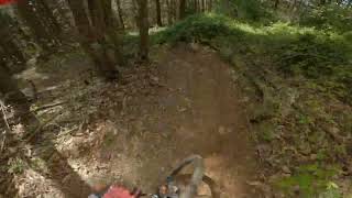
Very flowy & fast enduro - DH track w/ a few jump features.

Ca commence avec quelques virages a plat, puis ca deviens plus raide et rapide et des petit sauts appairsent. Il ya un super flow et plus de saut arrive a mesure que l'on descend . La difficulté "Rouge" de la piste vient des saut qui y sont present (double et shark fin), ils peuvent être evités facilement, pas de difficulté technique particulière.

It begin with some pretty flat turn then it get steeper and faster and little jumps appear. Super good flow, more jumps and speed as you go down. The "red" grade of the trail is due to the jumps (double and shark fin) which can be avoid esealy, no technical difficulty.

Access Info

Be careful in the Bourdelles village, locals are aware of the mtb frequentation but aren't fans of shuttles. You might want to park nearby the "salle des combarelles", then climb by following the fire road up to the top.

Recent Activity on Trail

Past Week
  • 0 rides
  •  
6 Months
  • 4 rides
  • 11 miles avg distance
All
  • 34 rides
  • Last: May 2, 2026
c1c2c3c4
January
February
March
April
May
June
July
August
September
October
November
December
update trails status or condition

Bourdelles Trail Reports

statusdatedescription
Mar 27, 2026 @ 1:16pm (Europe/Paris)
Mar 27, 2026
coupe forestières
Aug 20, 2025 @ 5:45pm
Aug 20, 2025
La pluie a un peu détérioré la piste des branches et cailloux à enlever
Apr 26, 2025 @ 10:56am
Apr 26, 2025
Super nickel!! Trop bon
Apr 12, 2025 @ 8:08am
Apr 12, 2025
Top grip descente nettoyée
Mar 29, 2025 @ 7:45am
Mar 29, 2025
Déjà un peu sèche malgré les pluies
more »
Status:
on Mar 27, 2026
Avg: 4.39 (4 votes)
Your vote: 0

view (833)
close
3D
Trail Conditions
  • Unknown
  • Snow Groomed
  • Snow Packed
  • Snow Covered
  • Snow Cover Partial
  • Freeze/thaw Cycle
  • Icy
  • Prevalent Mud
  • Wet
  • Variable
  • Ideal
  • Dry
  • Very Dry
Trail Flow (Ridden Direction)
Trailforks scans users ridelogs to determine the most popular direction each trail is ridden. A good flowing trail network will have most trails flowing in a single direction according to their intension.
The colour categories are based on what percentage of riders are riding a trail in its intended direction.
  • > 96%
  • > 90%
  • > 80%
  • > 70%
  • > 50%
  • < 50%
  • bi-directional trail
  • no data
Trail Last Ridden
Trailforks scans ridelogs to determine the last time a trail was ridden.
  • < 2 days
  • < 1 week
  • < 2 weeks
  • < 1 month
  • < 6 months
  • > 6 months
Trail Ridden Direction
The intended direction a trail should be ridden.
  • Downhill Only
  • Downhill Primary
  • Both Directions
  • Uphill Primary
  • Uphill Only
  • One Direction
Contribute Details
Colors indicate trail is missing specified detail.
  • Description
  • Photos
  • Description & Photos
  • Videos
Trail Popularity ?
Trailforks scans ridelogs to determine which trails are ridden the most in the last 9 months. Trails are compared with nearby trails in the same city region with a possible 25 colour shades. Think of this as a heatmap, more rides = more kinetic energy = warmer colors.
  • most popular
  • popular
  • less popular
  • not popular
ATV/ORV/OHV Filter
Max Vehicle Width
inches
US Cell Coverage
Legend
cell carrier legend

Radar Time
Activity Recordings
Trailforks uses anonymized public activity data. ?
Activity Recordings
Trailforks uses anonymized public activity data. ?
Personal Heatmap
Activity Types
all / none
Options
2
Date range month
Winter Trails
Warning A routing network for winter maps does not exist. Selecting trails using the winter trails layer has been disabled.
Missing Trails
Most Popular
Least Popular
Trails are colored based on popularity. The more popular a trail is, the more red. Less popular trails trend towards green.
Jump Magnitude Heatmap
Heatmap of where riders jump on trails. Zoom in to see individual jumps, click circles to view jump details.
BC Backroad Status

Service Road Atlas is a free to use, community-driven service for viewing and creating reports on the numerous back-country service roads around B.C. and Alberta.

map legend
Slope Aspect
Direction the slope faces
Flat N NE E SE S SW W NW
Trails Deemphasized
Trails are shown in grey.
disable
Only show trails with no bike usage.
Enable
Suggested Layers
Based on selected activity type

    Save the current map location and zoom level as your default home location whenever this page is loaded.

    Save
        Directions to bourdelles trailhead (43.643490, 3.087100)

        Photos

        2 more »
        67 |
        Jul 1, 2022 @ 1:32pm
        Jul 1, 2022
        72 |
        Jul 1, 2022 @ 1:32pm
        Jul 1, 2022

        Videos

        1 more »
        Bourdelles, Le Pradal, Herault, France
        3:41 | 65 | May 11, 2025 , Le Pradal

        1 Review & Comments


        We hope you've been enjoying Trailforks!

        Create a FREE account to view trail comments and much more.

        • By kikouTF Pro & contributors
        • #294865 - 730 views

        Frequently Asked Questions About Bourdelles

        Where is Bourdelles located?
        Bourdelles is located in Le Pradal, France. It is part of the Le Pradal trail network. The trailhead is located at coordinates 43.64349, 3.0871.
        How hard is Bourdelles?
        Bourdelles is rated as Red difficulty. The physical rating is Moderate. The average grade is 16.1%.
        What is the elevation gain for Bourdelles?
        Bourdelles has 4 m of elevation gain. The trail has 237 m of elevation descent. The elevation ranges from 411 m to 647 m.
        Is Bourdelles a point to point trail?
        Yes, Bourdelles is a point to point trail. The direction is Downhill Only. The trail type is singletrack.

        Hit the Trail

        Open in App

        Get this trail on your phone instantly.
        open trail in app

        Download Trail

        Save to wishlist, Garmin & download.
        save the trail

        Find Related Routes

        Find routes and users activities that include this trail.
        find routes for this trail

        You must enter a description before submitting.