more stats
1.2 miles
Distance
214 ft
Climb
-673 ft
Descent
00:09:04
Avg time
-459 ft
Altitude change
135 ft
Altitude min
600 ft
Altitude max
597 ft
Altitude start
138 ft
Altitude end
-7.5%
Grade
-67%
Grade max
38.6%
Grade min
1,719 ft
Distance climb
2,927 ft
Distance down
1,463 ft
Distance flat
00:09:04
Avg time

Bowenvale Downhill Details

  • Activities
    • Mountain Bike
    • E-Bike
    • Trail Running
  • Riding Area
    Port Hills West
    Christchurch
  • Difficulty Rating
  • Local Popularity
    80 in Mountain Biking [+]
    • 70 in Trail Running
  • Global Ranking
    #39361 in Mountain Biking [+]
    • #50357 in Trail Running
  • Trail Exposure
    Normal
  • Trail Type
    Singletrack
  • Bike Type
    DH, AM, XC
  • Direction
    Downhill Primary[+]
    • Downhill Primary for E-Biking
    • Downhill Primary for Trail Running
  • Climb Difficulty
    Black Diamond
  • Physical Rating
    Moderate
  • Trail Visibility
    Always easy to follow
  • Dogs Allowed
    Yes
  • eBike Allowed
    Yes up to Class 1
  • Land Owner
    Christchurch City Council

Start: Ride from Victoria Park along the Bowenvale Traverse Track to the top of Huntsbury Track near the Summit Road.

Finish: The bottom of Bowenvale Valley on the 4WD track. From the 4WD track it's a short ride out to Bowenvale Avenue.

Access: The fastest access is to ride the Bowenvale Traverse Track from Victoria Park. Alternatively ride up Rapaki Track and then take the Mt Vernon Track through to its end at the top of Huntsbury.

Signage: The track is sign posted at the airstrip.
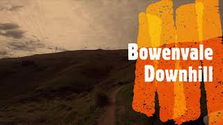
- Classed as a grade three ride, this track was the first down hill track built on the Port Hills in the mid 90's.

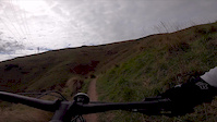
- Start riding down the gravel surfaced 4WD Huntsbury Track for approx 500 metres.

- At an obvious junction at the head of an old airstrip turn left and follow a steep 4WD track that zig zags it's way down into the valley. The track surface is rough and riddled with ruts – so don't forget to hang on.

- At a pylon the track narrows to a fast flowing single track that takes you to the valley floor and the Bowenvale Valley 4WD Track.

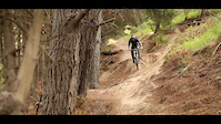
This section of this track has recently been re-built, and offers some fun riding with many switch back corners and lots of grade reversal to pump through while traversing back and forth across the hill country.

Trail Supporters
Local Trail Association
Traditionally Indigenous Territory

Recent Activity on Trail

Past Week
  • 4 rides
  • 16.2 km average
6 Months
  • 69 rides
  • 16.6 km avg distance
All
  • 192 rides
  • Last: Jun 19, 2026
c1c2c3c4
January
February
March
April
May
June
July
August
September
October
November
December
update trails status or condition

Bowenvale Downhill Trail Reports

statusdatedescription
Apr 13, 2025 @ 3:03am
Apr 13, 2025
A few new bridges placed in the lower sections, old original bridges in the upper sections have some broken boards. Trail feel cleaner… less rocky?
Sep 6, 2024 @ 9:47am
Sep 6, 2024
May 24, 2024 @ 9:39pm
May 24, 2024
A bit damp with some good hero dirt but lower parts need rebuild with some large pot holes forming on the ends of the bridges
May 24, 2024 @ 9:39pm
May 24, 2024
A bit damp with some good hero dirt but lower parts need rebuild with some large pot holes forming on the ends of the bridges
May 24, 2024 @ 9:39pm
May 24, 2024
A bit damp with some good hero dirt but lower parts need rebuild with some large pot holes forming on the ends of the bridges
more »
Status:
on Apr 13, 2025
Dry
Avg: 4 (15 votes)
Your vote: 0

view (2,484)
close
3D
Trail Conditions
  • Unknown
  • Snow Groomed
  • Snow Packed
  • Snow Covered
  • Snow Cover Partial
  • Freeze/thaw Cycle
  • Icy
  • Prevalent Mud
  • Wet
  • Variable
  • Ideal
  • Dry
  • Very Dry
Trail Flow (Ridden Direction)
Trailforks scans users ridelogs to determine the most popular direction each trail is ridden. A good flowing trail network will have most trails flowing in a single direction according to their intension.
The colour categories are based on what percentage of riders are riding a trail in its intended direction.
  • > 96%
  • > 90%
  • > 80%
  • > 70%
  • > 50%
  • < 50%
  • bi-directional trail
  • no data
Trail Last Ridden
Trailforks scans ridelogs to determine the last time a trail was ridden.
  • < 2 days
  • < 1 week
  • < 2 weeks
  • < 1 month
  • < 6 months
  • > 6 months
Trail Ridden Direction
The intended direction a trail should be ridden.
  • Downhill Only
  • Downhill Primary
  • Both Directions
  • Uphill Primary
  • Uphill Only
  • One Direction
Contribute Details
Colors indicate trail is missing specified detail.
  • Description
  • Photos
  • Description & Photos
  • Videos
Trail Popularity ?
Trailforks scans ridelogs to determine which trails are ridden the most in the last 9 months. Trails are compared with nearby trails in the same city region with a possible 25 colour shades. Think of this as a heatmap, more rides = more kinetic energy = warmer colors.
  • most popular
  • popular
  • less popular
  • not popular
ATV/ORV/OHV Filter
Max Vehicle Width
inches
US Cell Coverage
Legend
cell carrier legend

Radar Time
Activity Recordings
Trailforks uses anonymized public activity data. ?
Activity Recordings
Trailforks uses anonymized public activity data. ?
Personal Heatmap
Activity Types
all / none
Options
2
Date range month
Winter Trails
Warning A routing network for winter maps does not exist. Selecting trails using the winter trails layer has been disabled.
Missing Trails
Most Popular
Least Popular
Trails are colored based on popularity. The more popular a trail is, the more red. Less popular trails trend towards green.
Jump Magnitude Heatmap
Heatmap of where riders jump on trails. Zoom in to see individual jumps, click circles to view jump details.
BC Backroad Status

Service Road Atlas is a free to use, community-driven service for viewing and creating reports on the numerous back-country service roads around B.C. and Alberta.

map legend
Slope Aspect
Direction the slope faces
Flat N NE E SE S SW W NW
Trails Deemphasized
Trails are shown in grey.
disable
Only show trails with no bike usage.
Enable
Suggested Layers
Based on selected activity type

    Save the current map location and zoom level as your default home location whenever this page is loaded.

    Save
        Directions to bowenvale-downhill trailhead (-43.588900, 172.653220)

        Photos

        5 more »
        63 |
        Apr 30, 2019 @ 9:04pm
        Apr 30, 2019
        73 |
        Apr 30, 2019 @ 9:04pm
        Apr 30, 2019
        235 |
        Jan 3, 2016 @ 3:57pm
        Jan 3, 2016
        705 |
        Jun 28, 2015 @ 3:58pm
        Jun 28, 2015

        Videos

        6 more »
        Bowenvale Downhill - Port Hills West,...
        6:56 | 405 | Sep 18, 2020 , Christchurch
        An Evening down the Old Bowenvale Downhill...
        11:10 | 576 | Oct 10, 2018 , Christchurch
        Bowenvale DH Christchurch NZ
        6:55 | 171 | Sep 23, 2020 , Christchurch
        Christchurch - Josh Birkenhake
        0:27 | 2861 | May 31, 2018 , Christchurch

        Routes with this trail

        29 miles 8,806 ft 34 Out & Back Race
        The Phoenix Enduro is back for its fourth year! 2 days practice on the 27th & 28th race day the 29th...

        Reviews / Comments

        No reviews yet, be the first to write a review or ask a question.
        Use trail reports to comment on trail conditions.


        We hope you've been enjoying Trailforks!

        Create a FREE account to view trail comments and much more.

        • By nakinoahTF Pro & contributors
        • #27781 - 15,591 views

        Frequently Asked Questions About Bowenvale Downhill

        Where is Bowenvale Downhill located?
        Bowenvale Downhill is located in Port Hills West, Christchurch, New Zealand. It is part of the Port Hills West trail network. The trailhead is located at coordinates -43.5889, 172.65322.
        How hard is Bowenvale Downhill?
        Bowenvale Downhill is rated as Advanced difficulty. The physical rating is Moderate. The average grade is 7.5%. The climb difficulty is rated Black Diamond.
        What is the elevation gain for Bowenvale Downhill?
        Bowenvale Downhill has 214 ft of elevation gain. The trail has 673 ft of elevation descent. The elevation ranges from 135 ft to 600 ft.
        Is Bowenvale Downhill a point to point trail?
        Bowenvale Downhill is not a point to point trail. The direction is Downhill Primary. The trail type is singletrack.

        Hit the Trail

        Open in App

        Get this trail on your phone instantly.
        open trail in app

        Download Trail

        Save to wishlist, Garmin & download.
        save the trail

        Find Related Routes

        Find routes and users activities that include this trail.
        find routes for this trail

        You must enter a description before submitting.