more stats
2.3 miles
Distance
198 ft
Climb
-319 ft
Descent
00:15:02
Avg time
-120 ft
Altitude change
3,531 ft
Altitude min
3,655 ft
Altitude max
3,653 ft
Altitude start
3,533 ft
Altitude end
-1%
Grade
-21.8%
Grade max
27%
Grade min
3,645 ft
Distance climb
1 mile
Distance down
1,699 ft
Distance flat
00:15:02
Avg time

Bowmont Singletrack Details

  • Activities
    • Mountain Bike
    • E-Bike
    • Hike
    • Trail Running
  • Riding Area
    Bowmont Park
    Calgary, Alberta
  • Difficulty Rating
  • Voted Difficulty
    Green (1 vote)
  • Local Popularity
    70 in Mountain Biking [+]
    • 80 in E-Biking
    • 5 in Trail Running
    • 5 in Hiking
  • Global Ranking
    #55157 in Mountain Biking [+]
    • #113507 in Trail Running
    • #120921 in Hiking
  • Trail Type
    Singletrack
  • Bike Type
    AM, XC
  • Direction
    Both Directions
  • Climb Difficulty
    Blue
  • Physical Rating
    Moderate
  • Season
    Year Round
  • Dogs Allowed
    Yes
  • eBike Allowed
    Yes up to Class 1

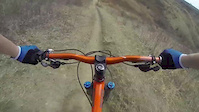
This is a route that follows some of the popular singletrack in Bowmont Park. Following the banks of the Bow River you will be treated to some decent undulating inner city dirt with a few short punchy climbs. This route can be linked up with Sideshow Bob directly to the SE and Twelve Mile Coulee to the NW via a couple km of new paved pathway and tunnels under Stoney Trail. Generally dries out fairly quickly after rain as it is exposed river bank. During winter it can be good fatbiking conditions, and very often rideable on a regular MTB with studs due to walkers and Chinooks.

Be prepared to yield to dog walkers and oncoming bike traffic, especially on blind corners.

There is one section near the Silver Springs ravine that does not allow bikes, stick to the upper track, signage is obvious.

Access Info

From the west you can park at the Bowmont Park lot that is on 51 Ave NW, near the corner of Bearspaw Dam Rd and 85 St NW. From the east you can park at the lot near Maranatha Church and take Sideshow westbound or the paved path. There are also numerous drop in points along the way, one of the more popular being the corner of Silver Springs Blvd and 54 Ave NW.

Recent Activity on Trail

Past Week
  • 0 rides
  •  
6 Months
  • 11 rides
  • 23.1 km avg distance
All
  • 101 rides
  • Last: Jun 12, 2026
c1c2c3c4
January
February
March
April
May
June
July
August
September
October
November
December
update trails status or condition

Bowmont Singletrack Trail Reports

Status:
on May 11, 2024
Dry
Avg: 3.79 (9 votes)
Your vote: 0

view (617)
close
3D
Trail Conditions
  • Unknown
  • Snow Groomed
  • Snow Packed
  • Snow Covered
  • Snow Cover Partial
  • Freeze/thaw Cycle
  • Icy
  • Prevalent Mud
  • Wet
  • Variable
  • Ideal
  • Dry
  • Very Dry
Trail Flow (Ridden Direction)
Trailforks scans users ridelogs to determine the most popular direction each trail is ridden. A good flowing trail network will have most trails flowing in a single direction according to their intension.
The colour categories are based on what percentage of riders are riding a trail in its intended direction.
  • > 96%
  • > 90%
  • > 80%
  • > 70%
  • > 50%
  • < 50%
  • bi-directional trail
  • no data
Trail Last Ridden
Trailforks scans ridelogs to determine the last time a trail was ridden.
  • < 2 days
  • < 1 week
  • < 2 weeks
  • < 1 month
  • < 6 months
  • > 6 months
Trail Ridden Direction
The intended direction a trail should be ridden.
  • Downhill Only
  • Downhill Primary
  • Both Directions
  • Uphill Primary
  • Uphill Only
  • One Direction
Contribute Details
Colors indicate trail is missing specified detail.
  • Description
  • Photos
  • Description & Photos
  • Videos
Trail Popularity ?
Trailforks scans ridelogs to determine which trails are ridden the most in the last 9 months. Trails are compared with nearby trails in the same city region with a possible 25 colour shades. Think of this as a heatmap, more rides = more kinetic energy = warmer colors.
  • most popular
  • popular
  • less popular
  • not popular
ATV/ORV/OHV Filter
Max Vehicle Width
inches
US Cell Coverage
Legend
cell carrier legend

Radar Time
Activity Recordings
Trailforks uses anonymized public activity data. ?
Activity Recordings
Trailforks uses anonymized public activity data. ?
Personal Heatmap
Activity Types
all / none
Options
2
Date range month
Winter Trails
Warning A routing network for winter maps does not exist. Selecting trails using the winter trails layer has been disabled.
Missing Trails
Most Popular
Least Popular
Trails are colored based on popularity. The more popular a trail is, the more red. Less popular trails trend towards green.
Jump Magnitude Heatmap
Heatmap of where riders jump on trails. Zoom in to see individual jumps, click circles to view jump details.
BC Backroad Status

Service Road Atlas is a free to use, community-driven service for viewing and creating reports on the numerous back-country service roads around B.C. and Alberta.

map legend
Slope Aspect
Direction the slope faces
Flat N NE E SE S SW W NW
Trails Deemphasized
Trails are shown in grey.
disable
Only show trails with no bike usage.
Enable
Suggested Layers
Based on selected activity type

    Save the current map location and zoom level as your default home location whenever this page is loaded.

    Save
        Directions to bowmont-singletrack trailhead (51.104060, -114.209200)

        Photos

        36 more »
        162 |
        May 24, 2020 @ 12:48am
        May 24, 2020
        355 |
        May 24, 2020 @ 12:48am
        May 24, 2020
        230 |
        Jul 20, 2017 @ 7:27am
        Jul 20, 2017
        44 |
        Aug 27, 2023 @ 12:29pm
        Aug 27, 2023

        Videos

        3 more »
        Silver springs calgary fall 2020
        2:42 | 527 | Oct 2, 2020 , Calgary
        Go it Alone - Mountain Bike Trails Calgary
        1323 | Sep 8, 2016 , Calgary
        It Begins
        3:39 | 1012 | Apr 27, 2013 , Calgary

        Routes with this trail

        5.0 7 miles 718 ft 9
        Great mix of technical single track and pathway. I prefer to do this trail as an out and back starting at...
        4 miles 388 ft 12
        Rip through Bowmont.........

        6 Reviews & Comments


        We hope you've been enjoying Trailforks!

        Create a FREE account to view trail comments and much more.

        • By BigFeller & contributors
        • #42899 - 13,104 views

        Frequently Asked Questions About Bowmont Singletrack

        Where is Bowmont Singletrack located?
        Bowmont Singletrack is located in Bowmont Park, Calgary, Alberta, Canada. It is part of the Bowmont Park trail network. The trailhead is located at coordinates 51.10406, -114.2092.
        How hard is Bowmont Singletrack?
        Bowmont Singletrack is rated as Green difficulty. The physical rating is Moderate. The average grade is 1%. The climb difficulty is rated Blue.
        What is the elevation gain for Bowmont Singletrack?
        Bowmont Singletrack has 198 ft of elevation gain. The trail has 319 ft of elevation descent. The elevation ranges from 3,531 ft to 3,655 ft.
        Is Bowmont Singletrack a point to point trail?
        Bowmont Singletrack is not a point to point trail. The direction is Both Directions. The trail type is singletrack.

        Hit the Trail

        Open in App

        Get this trail on your phone instantly.
        open trail in app

        Download Trail

        Save to wishlist, Garmin & download.
        save the trail

        Find Related Routes

        Find routes and users activities that include this trail.
        find routes for this trail

        You must enter a description before submitting.