more stats
1.5 miles
Distance
4 ft
Climb
-996 ft
Descent
00:13:07
Avg time
-994 ft
Altitude change
1,059 ft
Altitude min
2,053 ft
Altitude max
2,053 ft
Altitude start
1,060 ft
Altitude end
-12.2%
Grade
-38.7%
Grade max
6%
Grade min
312 ft
Distance climb
1 mile
Distance down
666 ft
Distance flat
00:13:07
Avg time

Braille Trail Details

  • Activities
    • Mountain Bike
    • Hike
    • Trail Running
  • Riding Area
    Soquel Demonstration State Forest
    Santa Cruz, California
  • Difficulty Rating
  • Voted Difficulty
    Black Diamond (13 votes)
  • Local Popularity
    85 in Mountain Biking [+]
    • 5 in Trail Running
    • 75 in Hiking
  • Global Ranking
    #2110 in Mountain Biking
  • Hiking SAC Scale
    T3 Demanding Mountain Hiking
  • Trail Exposure
    High Risk
  • Trail Type
    Singletrack
  • Bike Type
    DH, AM
  • Direction
    Downhill Only[+]
    Popular Direction Shown
    • Downhill Only for Trail Running
    • Downhill Only for Hiking
  • Climb Difficulty
    Black Diamond
  • Physical Rating
    Hard
  • Trail Visibility
    Always easy to follow
  • Season
    Whenever it isn't too muddy.
  • Dogs Allowed
    Yes
  • eBike Allowed
  • TTFs on Trail
    Berm, Bridge, Drop, Jump, Ladder Bridge, Log Ride, Rock Garden, Roller Coaster
  • Land Owner
    CAL FIRE

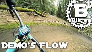
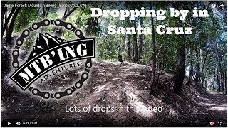
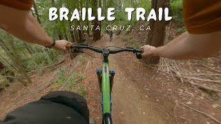
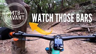
Braille is steep and natural. The trailhead off Ridge Trail has signage to call the top. As you enter on a fairly flat sector, you'll do a couple esses and soon come to a log drop of about 3-4 feet, and from there, it gets fun. Looking around as you descend you'll see at least 5 ramp jumps built by trail gnomes. Inspect them before you try them, as at one time or another they have all been awesome. But conditions cause change. It is easy to skip them and try them at a later date. The other items you'll find as you descend are steep (steep) scalloped skinny lines over roots. There is a skinny bridge and a teeter totter about half way down (easy to go-round). You can choose one or the other, but hitting both at speed is tough as they are not in line. As you get closer to the bottom the trail weaves between redwoods and has one G-out that may catch you in the wrong gear forcing you over a skinny a redwood ramp - 3 ft. gully bridge. Near the bottom is a fat four foot high fatty log with a ramp up and a huck to flat on the other end. Easy to by-pass, rewarding to hit. A new-ish route at the bottom has you come out parallel to the fire road. It was done to reduce getting t-boned on the fire road, but it requires a pedal stroke or four to get off the Braille.

Access Info

Take the road outside the park to the crest at Eureka Canyon, then ride up Buzzard lagoon into Nisene, and then to Rosalita for the Demo entrance. Then ride Ridge to the second trail (past Coral). Signs at the trailhead call out Braille.

or

Go down the fireroad and take Sulphur up, turn right at the Helipad, then within 400m is the trailhead with signage.

Local Trail Association
Traditionally Indigenous Territory

Recent Activity on Trail

Past Week
  • 3 rides
  • 20 miles average
6 Months
  • 155 rides
  • 19 miles avg distance
All
  • 951 rides
  • Last: Jun 20, 2026
c1c2c3c4
January
February
March
April
May
June
July
August
September
October
November
December
update trails status or condition

Braille Trail Trail Reports

statusdatedescription
Apr 26, 2026 @ 9:39am (America/Los_Angeles)
Apr 26, 2026
Apr 24, 2026 @ 11:43am (America/Los_Angeles)
Apr 24, 2026
reporter A few slick spots still drying out from rain earlier this week, but totally rideable!
Apr 23, 2026 @ 2:42pm (America/Los_Angeles)
Apr 23, 2026
reporter 18” madrone blocking trail in the steep midsection. Climb over. Chainsaw needed.
Feb 10, 2026 @ 11:09am (America/Los_Angeles)
Feb 10, 2026
reporter CREW G starting point - reroute - decommission
Feb 10, 2026 @ 10:53am (America/Los_Angeles)
Feb 10, 2026
reporter crew F starting point -drains
more »
Status:
on Apr 26, 2026
Wet
Avg: 4.71 (64 votes)
Your vote: 0

view (9,375)
close
3D
Trail Conditions
  • Unknown
  • Snow Groomed
  • Snow Packed
  • Snow Covered
  • Snow Cover Partial
  • Freeze/thaw Cycle
  • Icy
  • Prevalent Mud
  • Wet
  • Variable
  • Ideal
  • Dry
  • Very Dry
Trail Flow (Ridden Direction)
Trailforks scans users ridelogs to determine the most popular direction each trail is ridden. A good flowing trail network will have most trails flowing in a single direction according to their intension.
The colour categories are based on what percentage of riders are riding a trail in its intended direction.
  • > 96%
  • > 90%
  • > 80%
  • > 70%
  • > 50%
  • < 50%
  • bi-directional trail
  • no data
Trail Last Ridden
Trailforks scans ridelogs to determine the last time a trail was ridden.
  • < 2 days
  • < 1 week
  • < 2 weeks
  • < 1 month
  • < 6 months
  • > 6 months
Trail Ridden Direction
The intended direction a trail should be ridden.
  • Downhill Only
  • Downhill Primary
  • Both Directions
  • Uphill Primary
  • Uphill Only
  • One Direction
Contribute Details
Colors indicate trail is missing specified detail.
  • Description
  • Photos
  • Description & Photos
  • Videos
Trail Popularity ?
Trailforks scans ridelogs to determine which trails are ridden the most in the last 9 months. Trails are compared with nearby trails in the same city region with a possible 25 colour shades. Think of this as a heatmap, more rides = more kinetic energy = warmer colors.
  • most popular
  • popular
  • less popular
  • not popular
ATV/ORV/OHV Filter
Max Vehicle Width
inches
US Cell Coverage
Legend
cell carrier legend

Radar Time
Activity Recordings
Trailforks uses anonymized public activity data. ?
Activity Recordings
Trailforks uses anonymized public activity data. ?
Personal Heatmap
Activity Types
all / none
Options
2
Date range month
Winter Trails
Warning A routing network for winter maps does not exist. Selecting trails using the winter trails layer has been disabled.
Missing Trails
Most Popular
Least Popular
Trails are colored based on popularity. The more popular a trail is, the more red. Less popular trails trend towards green.
Jump Magnitude Heatmap
Heatmap of where riders jump on trails. Zoom in to see individual jumps, click circles to view jump details.
BC Backroad Status

Service Road Atlas is a free to use, community-driven service for viewing and creating reports on the numerous back-country service roads around B.C. and Alberta.

map legend
Slope Aspect
Direction the slope faces
Flat N NE E SE S SW W NW
Trails Deemphasized
Trails are shown in grey.
disable
Only show trails with no bike usage.
Enable
Suggested Layers
Based on selected activity type

    Save the current map location and zoom level as your default home location whenever this page is loaded.

    Save
        Directions to braille-trail-28870 trailhead (37.073620, -121.888160)

        Photos

        38 more »
        61 |
        Mar 4, 2026 @ 12:35pm
        Mar 4, 2026
        477 |
        May 22, 2021 @ 6:22am
        May 22, 2021
        501 |
        May 8, 2021 @ 9:04am
        May 8, 2021
        954 |
        Jan 2, 2021 @ 12:03pm
        Jan 2, 2021

        Videos

        35 more »
        youtuber Demo's Flow - Flow & Braille Trail - Demo...
        15:03 | 1817 | Mar 16, 2018 , Santa Cruz
        youtuber Demo Forest (Santa Cruz, CA) Mountain Biking
        1814 | Jun 12, 2017 , Santa Cruz
        youtuber Braille Trail / Santa Cruz, CA (Soquel Demo...
        5:44 | 565 | May 15, 2024 , Santa Cruz
        youtuber ONE TAKE - Down Braille w/ commentary
        7:02 | 1325 | Feb 23, 2020 , Santa Cruz

        Routes with this trail

        5.0 18 miles 3,222 ft 14
        The Flow Trail is one of the best-known trails in Santa Cruz. It's 3.5 miles of fast, flowy downhill fun....
        2.0 19 miles 3,237 ft 11
        New route to try has both Braille and Flow!
        10 miles 1,549 ft 5
        One of the more popular routes at Demonstration Forest. Start at the parking lot. Take the road up to the...

        11 Reviews & Comments


        We hope you've been enjoying Trailforks!

        Create a FREE account to view trail comments and much more.

        Frequently Asked Questions About Braille Trail

        Where is Braille Trail located?
        Braille Trail is located in Soquel Demonstration State Forest, Santa Cruz, California, United States. It is part of the Soquel Demonstration State Forest trail network. The trailhead is located at coordinates 37.07362, -121.88816.
        How hard is Braille Trail?
        Braille Trail is rated as Black Diamond difficulty. The physical rating is Hard. The average grade is 12.2%. The climb difficulty is rated Black Diamond.
        What is the elevation gain for Braille Trail?
        Braille Trail has 4 ft of elevation gain. The trail has 996 ft of elevation descent. The elevation ranges from 1,059 ft to 2,053 ft.
        Is Braille Trail a point to point trail?
        Yes, Braille Trail is a point to point trail. The direction is Downhill Only. The trail type is singletrack.

        Hit the Trail

        Open in App

        Get this trail on your phone instantly.
        open trail in app

        Download Trail

        Save to wishlist, Garmin & download.
        save the trail

        Find Related Routes

        Find routes and users activities that include this trail.
        find routes for this trail

        You must enter a description before submitting.