more stats
3,993 ft
Distance
57 ft
Climb
-379 ft
Descent
00:07:26
Avg time
-323 ft
Altitude change
4,271 ft
Altitude min
4,609 ft
Altitude max
4,594 ft
Altitude start
4,272 ft
Altitude end
-8.1%
Grade
-38.2%
Grade max
15.5%
Grade min
912 ft
Distance climb
2,694 ft
Distance down
387 ft
Distance flat
00:07:26
Avg time

Brewer Details

  • Activities
    • Mountain Bike
    • Hike
    • Trail Running
  • Riding Area
    Carroll Canyon
    Sedona, Arizona
  • Difficulty Rating
  • Local Popularity
    85 in Mountain Biking [+]
    • 70 in Trail Running
    • 60 in Hiking
  • Global Ranking
    #8581 in Mountain Biking [+]
    • #58284 in Trail Running
    • #89226 in Hiking
  • Trail Type
    Singletrack
  • Bike Type
    AM
  • Direction
    Downhill Primary
    Popular Direction Shown
  • Climb Difficulty
    Double Black Diamond
  • Physical Rating
    Easy
  • Dogs Allowed
    Yes
  • eBike Allowed
  • TTFs on Trail
    Rock Garden

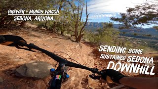
Intermediate 30% and advanced 70%, .8 mile MTB trail which is a one directional singletrack that is a fast technical mostly downhill trail. Some spots have short 18” drop sections that increase the fun factor. The trail tread is very rocky, so leg armor is highly recommended. The trail is a good connector for several other fun rides.

Trail Supporters
Local Trail Association

Recent Activity on Trail

Past Week
  • 0 rides
  •  
6 Months
  • 83 rides
  • 14 miles avg distance
All
  • 389 rides
  • Last: Jun 22, 2026
c1c2c3c4
January
February
March
April
May
June
July
August
September
October
November
December
Status:
on May 15, 2025
Dry
Avg: 4.34 (17 votes)
Your vote: 0

view (4,011)
close
3D
Trail Conditions
  • Unknown
  • Snow Groomed
  • Snow Packed
  • Snow Covered
  • Snow Cover Partial
  • Freeze/thaw Cycle
  • Icy
  • Prevalent Mud
  • Wet
  • Variable
  • Ideal
  • Dry
  • Very Dry
Trail Flow (Ridden Direction)
Trailforks scans users ridelogs to determine the most popular direction each trail is ridden. A good flowing trail network will have most trails flowing in a single direction according to their intension.
The colour categories are based on what percentage of riders are riding a trail in its intended direction.
  • > 96%
  • > 90%
  • > 80%
  • > 70%
  • > 50%
  • < 50%
  • bi-directional trail
  • no data
Trail Last Ridden
Trailforks scans ridelogs to determine the last time a trail was ridden.
  • < 2 days
  • < 1 week
  • < 2 weeks
  • < 1 month
  • < 6 months
  • > 6 months
Trail Ridden Direction
The intended direction a trail should be ridden.
  • Downhill Only
  • Downhill Primary
  • Both Directions
  • Uphill Primary
  • Uphill Only
  • One Direction
Contribute Details
Colors indicate trail is missing specified detail.
  • Description
  • Photos
  • Description & Photos
  • Videos
Trail Popularity ?
Trailforks scans ridelogs to determine which trails are ridden the most in the last 9 months. Trails are compared with nearby trails in the same city region with a possible 25 colour shades. Think of this as a heatmap, more rides = more kinetic energy = warmer colors.
  • most popular
  • popular
  • less popular
  • not popular
ATV/ORV/OHV Filter
Max Vehicle Width
inches
US Cell Coverage
Legend
cell carrier legend

Radar Time
Activity Recordings
Trailforks uses anonymized public activity data. ?
Activity Recordings
Trailforks uses anonymized public activity data. ?
Personal Heatmap
Activity Types
all / none
Options
2
Date range month
Winter Trails
Warning A routing network for winter maps does not exist. Selecting trails using the winter trails layer has been disabled.
Missing Trails
Most Popular
Least Popular
Trails are colored based on popularity. The more popular a trail is, the more red. Less popular trails trend towards green.
Jump Magnitude Heatmap
Heatmap of where riders jump on trails. Zoom in to see individual jumps, click circles to view jump details.
BC Backroad Status

Service Road Atlas is a free to use, community-driven service for viewing and creating reports on the numerous back-country service roads around B.C. and Alberta.

map legend
Slope Aspect
Direction the slope faces
Flat N NE E SE S SW W NW
Trails Deemphasized
Trails are shown in grey.
disable
Only show trails with no bike usage.
Enable
Suggested Layers
Based on selected activity type

    Save the current map location and zoom level as your default home location whenever this page is loaded.

    Save
        Directions to brewer trailhead (34.855740, -111.780020)

        Photos

        19 more »
        1,949 |
        Mar 10, 2020 @ 6:48am
        Mar 10, 2020
        257 |
        Mar 10, 2020 @ 6:48am
        Mar 10, 2020
        193 |
        Mar 10, 2020 @ 6:48am
        Mar 10, 2020
        190 |
        Mar 10, 2020 @ 6:49am
        Mar 10, 2020

        Videos

        13 more »
        youtuber Mountain Biking Brewer, Trail Boss Ride with...
        6:00 | 988 | Mar 16, 2018 , Sedona
        Sedona Trail Guide: Brewer
        4:17 | 59 | Feb 20, 2026 , Sedona
        youtuber Single Tracks: Sedona - Brewer
        6:44 | 145 | Apr 3, 2024 , Sedona
        Sustained Sedona Descents | Mountain Biking...
        11:07 | 180 | Feb 7, 2023 , Sedona

        Routes with this trail

        5.0 37 miles 5,341 ft 20 Loop
        Triple H has a new sibling. This ride combines four of the most technical trails in Sedona: Hardline,...
        3.2 30 miles 3,603 ft 56 Loop
        This is a classic Sedona high tech route using some of the iconic trails in the area: , Hogs & . This...
        10 miles 1,180 ft 8 Loop
        Start from Sky Ranch and head directly to the connector off the top of the airport to the Brewer Trailhead...

        6 Reviews & Comments


        We hope you've been enjoying Trailforks!

        Create a FREE account to view trail comments and much more.

        • By toddTF Pro Trailforks & contributors
        • #14978 - 11,705 views

        Frequently Asked Questions About Brewer

        Where is Brewer located?
        Brewer is located in Carroll Canyon, Sedona, Arizona, United States. It is part of the Carroll Canyon trail network. The trailhead is located at coordinates 34.85574, -111.78002.
        How hard is Brewer?
        Brewer is rated as Black Diamond difficulty. The physical rating is Easy. The average grade is 8.1%. The climb difficulty is rated Double Black Diamond.
        What is the elevation gain for Brewer?
        Brewer has 57 ft of elevation gain. The trail has 379 ft of elevation descent. The elevation ranges from 4,271 ft to 4,609 ft.
        Is Brewer a point to point trail?
        Brewer is not a point to point trail. The direction is Downhill Primary. The trail type is singletrack.

        Hit the Trail

        Open in App

        Get this trail on your phone instantly.
        open trail in app

        Download Trail

        Save to wishlist, Garmin & download.
        save the trail

        Find Related Routes

        Find routes and users activities that include this trail.
        find routes for this trail

        You must enter a description before submitting.