more stats
1.8 miles
Distance
83 ft
Climb
-912 ft
Descent
00:19:55
Avg time
-828 ft
Altitude change
100 ft
Altitude min
928 ft
Altitude max
928 ft
Altitude start
102 ft
Altitude end
-8.5%
Grade
-46.8%
Grade max
16.2%
Grade min
1,483 ft
Distance climb
1 mile
Distance down
338 ft
Distance flat
00:19:55
Avg time

Briga Destra Details

  • Activities
    • Mountain Bike
    • E-Bike
    • Hike
    • Trail Running
  • Riding Area
    Finale Outdoor Region
    Finale Ligure
  • Ref Number
    #10
  • AKA
    Briga Right
  • Difficulty Rating
  • Voted Difficulty
    Red (11 votes)
  • Local Popularity
    75 in Mountain Biking [+]
    • 70 in E-Biking
    • 35 in Trail Running
    • 60 in Hiking
  • Global Ranking
    #443 in Mountain Biking [+]
    • #1902 in E-Biking
    • #105386 in Trail Running
    • #1434 in Hiking
  • Hiking SAC Scale
    T1 Hiking
  • Trail Type
    Singletrack
  • Bike Type
    AM, XC
  • Direction
    Downhill Only
    Popular Direction Shown
  • Climb Difficulty
    Blue
  • Physical Rating
    Moderate
  • Trail Visibility
    Sometimes hard to follow
  • Season
    All-year round
  • eBike Allowed
    Yes up to Class 1

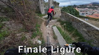
An all-time classic trail of Finale. As one of the first trails ever touched by mountainbikes, has a long history of racing, stages and great fun.
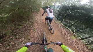
A proper enduro trail packed with fast sections, rocky corners, and a few small punchy climbs.

In its 3kms, starts close to the nearby peak Briga and ends up in the east part of the town. Great variety for a challenging track.

source: ...
Access Info

Le Manie Area is reachable from the E80 highway accessing Spotorno. You'll need to take the SP8, then the SP45 towards Voze and you'll soon get to the top of the plateau.
Other option is getting out of the E80 in Finale Ligure, cross the town on the Aurelia (SS1) and driving up toward Le Manie on the SP45.

Disclaimer

This trail is also used by hikers, be very careful. It crosses a white rad in the middle and a tarmac one after that. Chance of cars. The exit of the trails is on steps that lead to a road.

Local Trail Association

Recent Activity on Trail

Past Week
  • 2 rides
  • 51.3 km average
6 Months
  • 121 rides
  • 32.3 km avg distance
All
  • 633 rides
  • Last: Jun 17, 2026
c1c2c3c4
January
February
March
April
May
June
July
August
September
October
November
December
update trails status or condition

Briga Destra Trail Reports

statusdatedescription
May 30, 2026 @ 3:26pm (Europe/Monaco)
May 30, 2026
May 27, 2026 @ 3:25pm (Europe/Rome)
May 27, 2026
Dry but good condition. Some trimming work has been done today with greens laying in the trail, so watch out for sniper stones
May 6, 2026 @ 4:37pm (Europe/Rome)
May 6, 2026
Mwa, not the most fun tail
May 1, 2026 @ 10:35pm (Europe/Rome)
May 1, 2026
Apr 25, 2026 @ 9:44am (Europe/Monaco)
Apr 25, 2026
more »
Status:
on May 30, 2026
Dry
Avg: 3.96 (80 votes)
Your vote: 0

view (4,072)
close
3D
Trail Conditions
  • Unknown
  • Snow Groomed
  • Snow Packed
  • Snow Covered
  • Snow Cover Partial
  • Freeze/thaw Cycle
  • Icy
  • Prevalent Mud
  • Wet
  • Variable
  • Ideal
  • Dry
  • Very Dry
Trail Flow (Ridden Direction)
Trailforks scans users ridelogs to determine the most popular direction each trail is ridden. A good flowing trail network will have most trails flowing in a single direction according to their intension.
The colour categories are based on what percentage of riders are riding a trail in its intended direction.
  • > 96%
  • > 90%
  • > 80%
  • > 70%
  • > 50%
  • < 50%
  • bi-directional trail
  • no data
Trail Last Ridden
Trailforks scans ridelogs to determine the last time a trail was ridden.
  • < 2 days
  • < 1 week
  • < 2 weeks
  • < 1 month
  • < 6 months
  • > 6 months
Trail Ridden Direction
The intended direction a trail should be ridden.
  • Downhill Only
  • Downhill Primary
  • Both Directions
  • Uphill Primary
  • Uphill Only
  • One Direction
Contribute Details
Colors indicate trail is missing specified detail.
  • Description
  • Photos
  • Description & Photos
  • Videos
Trail Popularity ?
Trailforks scans ridelogs to determine which trails are ridden the most in the last 9 months. Trails are compared with nearby trails in the same city region with a possible 25 colour shades. Think of this as a heatmap, more rides = more kinetic energy = warmer colors.
  • most popular
  • popular
  • less popular
  • not popular
ATV/ORV/OHV Filter
Max Vehicle Width
inches
US Cell Coverage
Legend
cell carrier legend

Radar Time
Activity Recordings
Trailforks uses anonymized public activity data. ?
Activity Recordings
Trailforks uses anonymized public activity data. ?
Personal Heatmap
Activity Types
all / none
Options
2
Date range month
Winter Trails
Warning A routing network for winter maps does not exist. Selecting trails using the winter trails layer has been disabled.
Missing Trails
Most Popular
Least Popular
Trails are colored based on popularity. The more popular a trail is, the more red. Less popular trails trend towards green.
Jump Magnitude Heatmap
Heatmap of where riders jump on trails. Zoom in to see individual jumps, click circles to view jump details.
BC Backroad Status

Service Road Atlas is a free to use, community-driven service for viewing and creating reports on the numerous back-country service roads around B.C. and Alberta.

map legend
Slope Aspect
Direction the slope faces
Flat N NE E SE S SW W NW
Trails Deemphasized
Trails are shown in grey.
disable
Only show trails with no bike usage.
Enable
Suggested Layers
Based on selected activity type

    Save the current map location and zoom level as your default home location whenever this page is loaded.

    Save
        Directions to briga-destra trailhead (44.187250, 8.367240)

        Photos

        16 more »
        925 |
        Nov 1, 2021 @ 11:48am
        Nov 1, 2021
        1,597 |
        Oct 9, 2017 @ 2:57pm
        Oct 9, 2017
        91 |
        Jun 14, 2025 @ 12:40am
        Jun 14, 2025
        85 |
        Jun 14, 2025 @ 12:40am
        Jun 14, 2025

        Videos

        11 more »
        youtuber Финале Лигуре ден 4 -...
        1:7:45 | 134 | Dec 22, 2025 , Finale Ligure
        Finale Ligure eMTBing - Trail Briga Destra
        12:51 | 308 | Aug 7, 2025 , Finale Ligure
        BRIGA | FINALE LIGURE | ITALY |
        12:10 | 213 | Feb 23, 2025 , Finale Ligure
        Briga Destra | Finale Ligure | Hardtail Lover...
        8:02 | 436 | Jan 29, 2024 , Finale Ligure

        Trail Lists

        Routes with this trail

        3.3 22 miles 2,901 ft 10
        The track that hosts the “Most epic 24H race in the world”. (24H Finale) A scenic 12km loop perfect...
        5.0 48 miles 9,389 ft 51
        A mish mash of trails all over Finale
        20 miles 2,569 ft 9
        Finale Ligure, erste Option im November/Dezember 25

        20 Reviews & Comments


        We hope you've been enjoying Trailforks!

        Create a FREE account to view trail comments and much more.

        • By kaiser81TF Pro & contributors
        • #79608 - 14,389 views

        Frequently Asked Questions About Briga Destra

        Where is Briga Destra located?
        Briga Destra is located in Finale Outdoor Region, Finale Ligure, Italy. It is part of the Finale Outdoor Region trail network. The trailhead is located at coordinates 44.18725, 8.36724.
        How hard is Briga Destra?
        Briga Destra is rated as Blue difficulty. The physical rating is Moderate. The average grade is 8.5%. The climb difficulty is rated Blue.
        What is the elevation gain for Briga Destra?
        Briga Destra has 83 ft of elevation gain. The trail has 912 ft of elevation descent. The elevation ranges from 100 ft to 928 ft.
        Is Briga Destra a point to point trail?
        Yes, Briga Destra is a point to point trail. The direction is Downhill Only. The trail type is singletrack.

        Hit the Trail

        Open in App

        Get this trail on your phone instantly.
        open trail in app

        Download Trail

        Save to wishlist, Garmin & download.
        save the trail

        Find Related Routes

        Find routes and users activities that include this trail.
        find routes for this trail

        You must enter a description before submitting.