more stats
3,727 ft
Distance
75 ft
Climb
-70 ft
Descent
00:10:25
Avg time
6 ft
Altitude change
203 ft
Altitude min
256 ft
Altitude max
231 ft
Altitude start
236 ft
Altitude end
0.1%
Grade
-11.3%
Grade max
15.6%
Grade min
1,857 ft
Distance climb
1,624 ft
Distance down
95 ft
Distance flat
00:10:25
Avg time

Brinkslingan 1 Details

  • Activities
    • Hike
    • Mountain Bike
    • Winter Fat Bike
    • Trail Running
  • Riding Area
    Paradiset
    Huddinge
  • Difficulty Rating
  • Voted Difficulty
    Red (1 vote)
  • Local Popularity
    60 in Mountain Biking [+]
    • 80 in Trail Running
    • 100 in Hiking
  • Global Ranking
    #89372 in Mountain Biking [+]
    • #35241 in Trail Running
    • #3857 in Hiking
  • Hiking SAC Scale
    T1 Hiking
  • Trail Type
    Singletrack
  • Bike Type
    AM, XC, Fat
  • Direction
    Both Directions
  • Climb Difficulty
    Blue
  • Physical Rating
    Moderate
  • Trail Visibility
    Always easy to follow
  • Dogs Allowed
    Yes
  • eBike Allowed

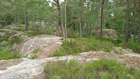
Brinkslingan går huvudsakligen genom skogs- och hällmarksterräng utom i sin östra del där den på cirka en kilometers sträcka följer en mindre bilväg. I terrängen är den markerad med diagonalt ställda gröna fyrkanter.
Vissa sträckor delas med Huddingeleden som har företräde visuellt här i Trailforks - dvs Brinkslingan är uppdelade pga Huddingeleden företräde. Brinkslingan i sin helhet finns istället som rut.

Local Trail Association

Recent Activity on Trail

Past Week
  • 0 rides
  •  
6 Months
  • 3 rides
  • 9 miles avg distance
All
  • 26 rides
  • Last: May 31, 2026
c1c2c3c4
January
February
March
April
May
June
July
August
September
October
November
December
update trails status or condition

Brinkslingan 1 Trail Reports

statusdatedescription
May 22, 2021 @ 12:56pm
May 22, 2021
Inte cykelvänlig på rätt många ställen. Sameslingan är betydligt roligare.
May 13, 2021 @ 7:48am
May 13, 2021
Några ordentligt blöta partier
Jun 28, 2020 @ 12:40pm
Jun 28, 2020
Min uppfattning: Inte så rolig slinga att cykla, mycket sten/block och andra hinder, svårt att få flyt i åkningen. Borde kanske inte vara blå...
Sep 2, 2018 @ 5:06am
Sep 2, 2018
Aug 18, 2018 @ 10:33pm
Aug 18, 2018
more »
Status:
on May 22, 2021
Wet
Avg: 3.98 (1 votes)
Your vote: 0

view (188)
close
3D
Trail Conditions
  • Unknown
  • Snow Groomed
  • Snow Packed
  • Snow Covered
  • Snow Cover Partial
  • Freeze/thaw Cycle
  • Icy
  • Prevalent Mud
  • Wet
  • Variable
  • Ideal
  • Dry
  • Very Dry
Trail Flow (Ridden Direction)
Trailforks scans users ridelogs to determine the most popular direction each trail is ridden. A good flowing trail network will have most trails flowing in a single direction according to their intension.
The colour categories are based on what percentage of riders are riding a trail in its intended direction.
  • > 96%
  • > 90%
  • > 80%
  • > 70%
  • > 50%
  • < 50%
  • bi-directional trail
  • no data
Trail Last Ridden
Trailforks scans ridelogs to determine the last time a trail was ridden.
  • < 2 days
  • < 1 week
  • < 2 weeks
  • < 1 month
  • < 6 months
  • > 6 months
Trail Ridden Direction
The intended direction a trail should be ridden.
  • Downhill Only
  • Downhill Primary
  • Both Directions
  • Uphill Primary
  • Uphill Only
  • One Direction
Contribute Details
Colors indicate trail is missing specified detail.
  • Description
  • Photos
  • Description & Photos
  • Videos
Trail Popularity ?
Trailforks scans ridelogs to determine which trails are ridden the most in the last 9 months. Trails are compared with nearby trails in the same city region with a possible 25 colour shades. Think of this as a heatmap, more rides = more kinetic energy = warmer colors.
  • most popular
  • popular
  • less popular
  • not popular
ATV/ORV/OHV Filter
Max Vehicle Width
inches
US Cell Coverage
Legend
cell carrier legend

Radar Time
Activity Recordings
Trailforks uses anonymized public activity data. ?
Activity Recordings
Trailforks uses anonymized public activity data. ?
Personal Heatmap
Activity Types
all / none
Options
2
Date range month
Winter Trails
Warning A routing network for winter maps does not exist. Selecting trails using the winter trails layer has been disabled.
Missing Trails
Most Popular
Least Popular
Trails are colored based on popularity. The more popular a trail is, the more red. Less popular trails trend towards green.
Jump Magnitude Heatmap
Heatmap of where riders jump on trails. Zoom in to see individual jumps, click circles to view jump details.
BC Backroad Status

Service Road Atlas is a free to use, community-driven service for viewing and creating reports on the numerous back-country service roads around B.C. and Alberta.

map legend
Slope Aspect
Direction the slope faces
Flat N NE E SE S SW W NW
Trails Deemphasized
Trails are shown in grey.
disable
Only show trails with no bike usage.
Enable
Suggested Layers
Based on selected activity type

    Save the current map location and zoom level as your default home location whenever this page is loaded.

    Save
        Directions to brinkslingan-1 trailhead (59.165560, 18.035710)

        Photos

        No photos have been added for Brinkslingan 1 yet, add a photo.

        Videos

        1 more »
        Visar var skåpet skall stå.
        0:19 | 511 | Jun 18, 2017 , Huddinge

        Routes with this trail

        17 miles 806 ft 37 Loop
        Utgår ifrån Västerhaninge mot Paradiset där man gör en stor loop. Och sedan hem igen till...

        Reviews / Comments

        No reviews yet, be the first to write a review or ask a question.
        Use trail reports to comment on trail conditions.


        We hope you've been enjoying Trailforks!

        Create a FREE account to view trail comments and much more.

        • By swoop-aeg & contributors
        • #26715 - 2,296 views

        Frequently Asked Questions About Brinkslingan 1

        Where is Brinkslingan 1 located?
        Brinkslingan 1 is located in Paradiset, Huddinge, Sweden. It is part of the Paradiset trail network. The trailhead is located at coordinates 59.16556, 18.03571.
        How hard is Brinkslingan 1?
        Brinkslingan 1 is rated as Red difficulty. The physical rating is Moderate. The average grade is 0.1%. The climb difficulty is rated Blue.
        What is the elevation gain for Brinkslingan 1?
        Brinkslingan 1 has 75 ft of elevation gain. The trail has 70 ft of elevation descent. The elevation ranges from 203 ft to 256 ft.
        Is Brinkslingan 1 a point to point trail?
        Brinkslingan 1 is not a point to point trail. The direction is Both Directions. The trail type is singletrack.

        Hit the Trail

        Open in App

        Get this trail on your phone instantly.
        open trail in app

        Download Trail

        Save to wishlist, Garmin & download.
        save the trail

        Find Related Routes

        Find routes and users activities that include this trail.
        find routes for this trail

        You must enter a description before submitting.