more stats
1,959 ft
Distance
3 ft
Climb
-329 ft
Descent
00:03:41
Avg time
-328 ft
Altitude change
756 ft
Altitude min
1,086 ft
Altitude max
1,085 ft
Altitude start
758 ft
Altitude end
-16.7%
Grade
-40.3%
Grade max
2.2%
Grade min
59 ft
Distance climb
1,654 ft
Distance down
246 ft
Distance flat
00:03:41
Avg time

Off Broadway Details

  • Activities
    • Mountain Bike
    • E-Bike
    • Hike
    • Trail Running
  • Riding Area
    Cumberland trail network
    Cumberland, British Columbia
  • Difficulty Rating
  • Voted Difficulty
    Black Diamond (2 votes)
  • Local Popularity
    85 in Mountain Biking [+]
    • 85 in E-Biking
    • 65 in Trail Running
    • 75 in Hiking
  • Global Ranking
    #19535 in Mountain Biking [+]
    • #5573 in E-Biking
    • #36185 in Trail Running
    • #36791 in Hiking
  • Trail Type
    Singletrack
  • Bike Type
    DH, AM
  • Direction
    Downhill Only
    Popular Direction Shown
  • Physical Rating
    Moderate
  • Season
    Feb - Dec.
  • Dogs Allowed
    Yes
  • eBike Allowed
  • TTFs on Trail
    Drop, Rock Face

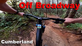
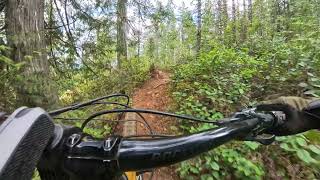
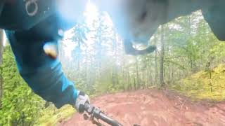
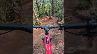
Steep and fun. Not for unexperienced riders. Has some steep lines with exposed drops to the canyon beside the trail.

Access Info

Cross Sykes Bridge, then left at the roadway. Stay left at each junction.

Local Trail Association
Traditionally Indigenous Territory

Recent Activity on Trail

Past Week
  • 22 rides
  • 13 miles average
6 Months
  • 293 rides
  • 12 miles avg distance
All
  • 2,722 rides
  • Last: Jun 17, 2026
c1c2c3c4
January
February
March
April
May
June
July
August
September
October
November
December
update trails status or condition

Off Broadway Trail Reports

Status:
on Jun 7, 2026
Ideal
Avg: 4.06 (42 votes)
Your vote: 0

view (12,694)
close
3D
Trail Conditions
  • Unknown
  • Snow Groomed
  • Snow Packed
  • Snow Covered
  • Snow Cover Partial
  • Freeze/thaw Cycle
  • Icy
  • Prevalent Mud
  • Wet
  • Variable
  • Ideal
  • Dry
  • Very Dry
Trail Flow (Ridden Direction)
Trailforks scans users ridelogs to determine the most popular direction each trail is ridden. A good flowing trail network will have most trails flowing in a single direction according to their intension.
The colour categories are based on what percentage of riders are riding a trail in its intended direction.
  • > 96%
  • > 90%
  • > 80%
  • > 70%
  • > 50%
  • < 50%
  • bi-directional trail
  • no data
Trail Last Ridden
Trailforks scans ridelogs to determine the last time a trail was ridden.
  • < 2 days
  • < 1 week
  • < 2 weeks
  • < 1 month
  • < 6 months
  • > 6 months
Trail Ridden Direction
The intended direction a trail should be ridden.
  • Downhill Only
  • Downhill Primary
  • Both Directions
  • Uphill Primary
  • Uphill Only
  • One Direction
Contribute Details
Colors indicate trail is missing specified detail.
  • Description
  • Photos
  • Description & Photos
  • Videos
Trail Popularity ?
Trailforks scans ridelogs to determine which trails are ridden the most in the last 9 months. Trails are compared with nearby trails in the same city region with a possible 25 colour shades. Think of this as a heatmap, more rides = more kinetic energy = warmer colors.
  • most popular
  • popular
  • less popular
  • not popular
ATV/ORV/OHV Filter
Max Vehicle Width
inches
US Cell Coverage
Legend
cell carrier legend

Radar Time
Activity Recordings
Trailforks uses anonymized public activity data. ?
Activity Recordings
Trailforks uses anonymized public activity data. ?
Personal Heatmap
Activity Types
all / none
Options
2
Date range month
Winter Trails
Warning A routing network for winter maps does not exist. Selecting trails using the winter trails layer has been disabled.
Missing Trails
Most Popular
Least Popular
Trails are colored based on popularity. The more popular a trail is, the more red. Less popular trails trend towards green.
Jump Magnitude Heatmap
Heatmap of where riders jump on trails. Zoom in to see individual jumps, click circles to view jump details.
BC Backroad Status

Service Road Atlas is a free to use, community-driven service for viewing and creating reports on the numerous back-country service roads around B.C. and Alberta.

map legend
Slope Aspect
Direction the slope faces
Flat N NE E SE S SW W NW
Trails Deemphasized
Trails are shown in grey.
disable
Only show trails with no bike usage.
Enable
Suggested Layers
Based on selected activity type

    Save the current map location and zoom level as your default home location whenever this page is loaded.

    Save
        Directions to broadway-0 trailhead (49.598520, -125.046060)

        Photos

        34 more »
        178 |
        Jun 26, 2017 @ 3:25pm
        Jun 26, 2017
        303 |
        Jun 26, 2017 @ 3:26pm
        Jun 26, 2017
        132 |
        Jun 26, 2017 @ 3:25pm
        Jun 26, 2017
        155 |
        Jun 26, 2017 @ 3:25pm
        Jun 26, 2017

        Videos

        13 more »
        Off Broadway - Cumberland 2026
        2:53 | 38 | May 24, 2026 , Cumberland
        Off Broadway (black)
        2:53 | 208 | May 3, 2025 , Cumberland
        off Broadway
        3:58 | 124 | Feb 5, 2025 , Cumberland
        Steep and loose with a great rock roll.
        0:00 | 193 | Nov 4, 2024 , Cumberland

        Trail Lists

        Routes with this trail

        4.0 14 miles 2,965 ft 17
        The Cumberland EPIC is a big, backcountry-style loop that links the highest and best outer trails in the...
        2.4 21 miles 4,909 ft 29
        Adapted version of Gravity Nines ‘23. "It’s all about riding downhill on some of Cumberland’s...
        22 miles 3,784 ft 22
        The famous DODGEZILLA is back for 2025, enjoy! Stage 1: Scat → Brat Stage 2: Teapot (Starting at Slick...

        8 Reviews & Comments


        We hope you've been enjoying Trailforks!

        Create a FREE account to view trail comments and much more.

        • By skifreakTF Pro & contributors
        • #1427 - 5,308 views

        Frequently Asked Questions About Off Broadway

        Where is Off Broadway located?
        Off Broadway is located in Cumberland trail network, Cumberland, British Columbia, Canada. It is part of the Cumberland trail network trail network. The trailhead is located at coordinates 49.59852, -125.04606.
        How hard is Off Broadway?
        Off Broadway is rated as Black Diamond difficulty. The physical rating is Moderate. The average grade is 16.7%.
        What is the elevation gain for Off Broadway?
        Off Broadway has 1 m of elevation gain. The trail has 100 m of elevation descent. The elevation ranges from 231 m to 331 m.
        Is Off Broadway a point to point trail?
        Yes, Off Broadway is a point to point trail. The direction is Downhill Only. The trail type is singletrack.

        Hit the Trail

        Open in App

        Get this trail on your phone instantly.
        open trail in app

        Download Trail

        Save to wishlist, Garmin & download.
        save the trail

        Find Related Routes

        Find routes and users activities that include this trail.
        find routes for this trail

        You must enter a description before submitting.