more stats
2.3 miles
Distance
102 ft
Climb
-904 ft
Descent
00:16:34
Avg time
-801 ft
Altitude change
7,122 ft
Altitude min
7,923 ft
Altitude max
7,923 ft
Altitude start
7,122 ft
Altitude end
-6.653%
Grade
-30.337%
Grade max
16.201%
Grade min
1,783 ft
Distance climb
2 miles
Distance down
531 ft
Distance flat
00:16:34
Avg time

Broadway Flow Trail Details

  • Activities
    • Mountain Bike
    • Hike
    • Trail Running
  • Riding Area
    Anthony Lakes Recreation Area
    Baker City, Oregon
  • Difficulty Rating
  • Voted Difficulty
    Blue (2 votes)
  • Local Popularity
    100 in Mountain Biking [+]
    • 5 in Trail Running
    • 5 in Hiking
  • Global Ranking
    #37050 in Mountain Biking [+]
    • #129801 in Trail Running
    • #122835 in Hiking
  • Trail Type
    Singletrack
  • Bike Type
    DH
  • Direction
    Downhill Only
    Popular Direction Shown
  • Physical Rating
    Moderate
  • Season
    summer
  • Alpine Trail
    Yes
  • Dogs Allowed
    Yes
  • TTFs on Trail
    Berm, Bridge, Ladder Bridge, Rock Face, Roller Coaster
  • Year Opened
    2018

Overview
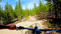
The recently constructed Broadway Flow Trail is a great way to warm up on your visit, with a base elevation of 7,100’ to keep you cool as the valley floor heats up. If you want additionally rocky terrain in your day then jump on the singletrack trails that roam around the resort, tucking in and out of the trees and across granite lines cut into the hillsides.

Route Details
The scenic drive to Anthony Lakes Mountain Resort will get you in the mood for the terrain you’ll encounter. As you wind your way up to the lodge, the trees will thin out and the granite slabs will become more prominent, until you arrive at the parking lot at just over 7,000’. Unless you’ve coming from another high-elevation destination, don’t try to sprint out of the gate or you’ll be gasping after 60 seconds.

The lift only runs for select events so unless you’ve timed your arrival with one of those weekends, you’ll need to earn your turns on the Broadway Flow Trail. The climb up is just under two miles with a couple steep pitches to make sure you’re legs are warmed up by the time you reach the top. The effort is worth it, though, because the descent packs a lot of twists and turns as you drop 800’ through berms and rollers built to maximize momentum. Take the first lap easy and get to know the trail, then head back up for a second time to link it all together with maximum flow. At this elevation, even pumping the trail will give you a workout.

A third lap brings it all together but if you’re already feeling your legs or if you want rockier terrain in your day then jump on the XC ski routes for some granite grinding. Although they are covered with snow in the winter, in the summer these routes turn into singletrack trails that provide a good challenge with short, scenic loops around the ski area, mixing in high-alpine loam with rocky outcroppings. Add just a couple miles or see if you can ride it all for the full experience.

Riding Season
The start of the riding season is dependent on the previous winter’s snowpack but plan on early summer through fall.

Trail Supporters

  • USFS
    Land Manager
Local Trail Association
Traditionally Indigenous Territory

Recent Activity on Trail

Past Week
  • 0 rides
  •  
6 Months
  • 0 rides
  •  
All
  • 76 rides
  • Last: Jun 15, 2026
c1c2c3c4
January
February
March
April
May
June
July
August
September
October
November
December
update trails status or condition

Broadway Flow Trail Trail Reports

statusdatedescription
Aug 10, 2025 @ 10:16am
Aug 10, 2025
Jun 15, 2025 @ 11:20am
Jun 15, 2025
Large patches of snow.
Oct 12, 2024 @ 10:24am
Oct 12, 2024
Jul 2, 2024 @ 6:31pm
Jul 2, 2024
Jun 21, 2024 @ 9:28pm
Jun 21, 2024
patchy snow. give it a few weeks to melt out and dry out
more »
Status:
on Aug 10, 2025
Dry
Avg: 4.2 (14 votes)
Your vote: 0

view (531)
close
3D
Trail Conditions
  • Unknown
  • Snow Groomed
  • Snow Packed
  • Snow Covered
  • Snow Cover Partial
  • Freeze/thaw Cycle
  • Icy
  • Prevalent Mud
  • Wet
  • Variable
  • Ideal
  • Dry
  • Very Dry
Trail Flow (Ridden Direction)
Trailforks scans users ridelogs to determine the most popular direction each trail is ridden. A good flowing trail network will have most trails flowing in a single direction according to their intension.
The colour categories are based on what percentage of riders are riding a trail in its intended direction.
  • > 96%
  • > 90%
  • > 80%
  • > 70%
  • > 50%
  • < 50%
  • bi-directional trail
  • no data
Trail Last Ridden
Trailforks scans ridelogs to determine the last time a trail was ridden.
  • < 2 days
  • < 1 week
  • < 2 weeks
  • < 1 month
  • < 6 months
  • > 6 months
Trail Ridden Direction
The intended direction a trail should be ridden.
  • Downhill Only
  • Downhill Primary
  • Both Directions
  • Uphill Primary
  • Uphill Only
  • One Direction
Contribute Details
Colors indicate trail is missing specified detail.
  • Description
  • Photos
  • Description & Photos
  • Videos
Trail Popularity ?
Trailforks scans ridelogs to determine which trails are ridden the most in the last 9 months. Trails are compared with nearby trails in the same city region with a possible 25 colour shades. Think of this as a heatmap, more rides = more kinetic energy = warmer colors.
  • most popular
  • popular
  • less popular
  • not popular
ATV/ORV/OHV Filter
Max Vehicle Width
inches
US Cell Coverage
Legend
cell carrier legend

Radar Time
Activity Recordings
Trailforks uses anonymized public activity data. ?
Activity Recordings
Trailforks uses anonymized public activity data. ?
Personal Heatmap
Activity Types
all / none
Options
2
Date range month
Winter Trails
Warning A routing network for winter maps does not exist. Selecting trails using the winter trails layer has been disabled.
Missing Trails
Most Popular
Least Popular
Trails are colored based on popularity. The more popular a trail is, the more red. Less popular trails trend towards green.
Jump Magnitude Heatmap
Heatmap of where riders jump on trails. Zoom in to see individual jumps, click circles to view jump details.
BC Backroad Status

Service Road Atlas is a free to use, community-driven service for viewing and creating reports on the numerous back-country service roads around B.C. and Alberta.

map legend
Slope Aspect
Direction the slope faces
Flat N NE E SE S SW W NW
Trails Deemphasized
Trails are shown in grey.
disable
Only show trails with no bike usage.
Enable
Suggested Layers
Based on selected activity type

    Save the current map location and zoom level as your default home location whenever this page is loaded.

    Save
        Directions to broadway-flow-trail trailhead (44.958420, -118.244890)

        Photos

        22 more »
        126 |
        Jan 20, 2023 @ 8:56pm
        Jan 20, 2023
        122 |
        Jan 20, 2023 @ 8:56pm
        Jan 20, 2023
        136 |
        Jan 20, 2023 @ 8:56pm
        Jan 20, 2023
        207 |
        Aug 2, 2020 @ 9:12pm
        Aug 2, 2020

        Videos

        3 more »
        Full trail POV
        12:33 | 630 | Jan 5, 2019 , Baker City
        Broadway in :60
        0:00 | 243 | Apr 14, 2020 , Baker City
        2 Dragon in :60
        0:00 | 128 | Apr 14, 2020 , Baker City

        7 Reviews & Comments


        We hope you've been enjoying Trailforks!

        Create a FREE account to view trail comments and much more.

        • By idmtbiker52TF Pro & contributors
        • #142340 - 4,245 views

        Frequently Asked Questions About Broadway Flow Trail

        Where is Broadway Flow Trail located?
        Broadway Flow Trail is located in Anthony Lakes Recreation Area, Baker City, Oregon, United States. It is part of the Anthony Lakes Recreation Area trail network. The trailhead is located at coordinates 44.95842, -118.24489.
        How hard is Broadway Flow Trail?
        Broadway Flow Trail is rated as Blue difficulty. The physical rating is Moderate. The average grade is 6.653%.
        What is the elevation gain for Broadway Flow Trail?
        Broadway Flow Trail has 102 ft of elevation gain. The trail has 904 ft of elevation descent. The elevation ranges from 7,122 ft to 7,923 ft.
        Is Broadway Flow Trail a point to point trail?
        Yes, Broadway Flow Trail is a point to point trail. The direction is Downhill Only. The trail type is singletrack.

        Hit the Trail

        Open in App

        Get this trail on your phone instantly.
        open trail in app

        Download Trail

        Save to wishlist, Garmin & download.
        save the trail

        Find Related Routes

        Find routes and users activities that include this trail.
        find routes for this trail

        You must enter a description before submitting.