more stats
1,312 ft
Distance
3 ft
Climb
-141 ft
Descent
00:01:39
Avg time
-141 ft
Altitude change
1,203 ft
Altitude min
1,344 ft
Altitude max
1,344 ft
Altitude start
1,204 ft
Altitude end
-10.7%
Grade
-24.7%
Grade max
2.3%
Grade min
62 ft
Distance climb
1,191 ft
Distance down
59 ft
Distance flat
00:01:39
Avg time

Brodown Details

  • Activities
    • Mountain Bike
    • E-Bike
  • Riding Area
    Diamond Head
    Squamish, British Columbia
  • Difficulty Rating
  • Local Popularity
    95 in Mountain Biking [+]
    • 95 in E-Biking
  • Global Ranking
    #32538 in Mountain Biking [+]
    • #15374 in E-Biking
  • Trail Type
    Singletrack
  • Bike Type
    DH, AM
  • Physical Rating
    Moderate
  • Trail Visibility
    Sometimes hard to follow
  • Dogs Allowed
    Yes
  • eBike Allowed
    Yes up to Class 1
  • TTFs on Trail
    Berm, Jump

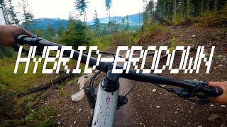
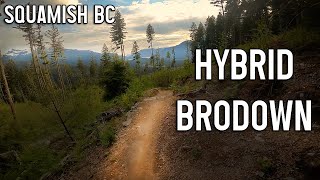
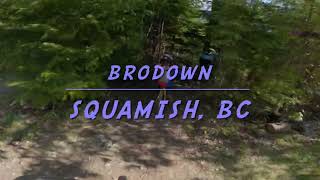
Bro Down was originally built in 2007 and rebuilt in spring 2021 by Ride BC. Hand work and machine time were funded through the Pamplemousse Pale Ale collaboration with Howe Sound Brewing as well as through Corsa Cycles. This short trail features lots of fun corners as well as some intermediate jumps to progress your skills. To support more builds like this you can pick up a 6 pack of Pamplemousse Pale Ale at Howe Sound and shop at Corsa Cycles Smile .

This trail has several intersections with neighbouring trails. Please be aware of other riders at these crossings and check your blind spots. Thanks and enjoy

Access Info

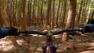
Hard right turn at the top of Lowdown part 2

Trail Supporters
Local Trail Association
Traditionally Indigenous Territory

Recent Activity on Trail

Past Week
  • 13 rides
  • 10 miles average
6 Months
  • 241 rides
  • 10 miles avg distance
All
  • 1,762 rides
  • Last: Jun 20, 2026
c1c2c3c4
January
February
March
April
May
June
July
August
September
October
November
December
Status:
on Jun 8, 2026
Ideal
Avg: 4.03 (23 votes)
Your vote: 0

view (9,398)
close
3D
Trail Conditions
  • Unknown
  • Snow Groomed
  • Snow Packed
  • Snow Covered
  • Snow Cover Partial
  • Freeze/thaw Cycle
  • Icy
  • Prevalent Mud
  • Wet
  • Variable
  • Ideal
  • Dry
  • Very Dry
Trail Flow (Ridden Direction)
Trailforks scans users ridelogs to determine the most popular direction each trail is ridden. A good flowing trail network will have most trails flowing in a single direction according to their intension.
The colour categories are based on what percentage of riders are riding a trail in its intended direction.
  • > 96%
  • > 90%
  • > 80%
  • > 70%
  • > 50%
  • < 50%
  • bi-directional trail
  • no data
Trail Last Ridden
Trailforks scans ridelogs to determine the last time a trail was ridden.
  • < 2 days
  • < 1 week
  • < 2 weeks
  • < 1 month
  • < 6 months
  • > 6 months
Trail Ridden Direction
The intended direction a trail should be ridden.
  • Downhill Only
  • Downhill Primary
  • Both Directions
  • Uphill Primary
  • Uphill Only
  • One Direction
Contribute Details
Colors indicate trail is missing specified detail.
  • Description
  • Photos
  • Description & Photos
  • Videos
Trail Popularity ?
Trailforks scans ridelogs to determine which trails are ridden the most in the last 9 months. Trails are compared with nearby trails in the same city region with a possible 25 colour shades. Think of this as a heatmap, more rides = more kinetic energy = warmer colors.
  • most popular
  • popular
  • less popular
  • not popular
ATV/ORV/OHV Filter
Max Vehicle Width
inches
US Cell Coverage
Legend
cell carrier legend

Radar Time
Activity Recordings
Trailforks uses anonymized public activity data. ?
Activity Recordings
Trailforks uses anonymized public activity data. ?
Personal Heatmap
Activity Types
all / none
Options
2
Date range month
Winter Trails
Warning A routing network for winter maps does not exist. Selecting trails using the winter trails layer has been disabled.
Missing Trails
Most Popular
Least Popular
Trails are colored based on popularity. The more popular a trail is, the more red. Less popular trails trend towards green.
Jump Magnitude Heatmap
Heatmap of where riders jump on trails. Zoom in to see individual jumps, click circles to view jump details.
BC Backroad Status

Service Road Atlas is a free to use, community-driven service for viewing and creating reports on the numerous back-country service roads around B.C. and Alberta.

map legend
Slope Aspect
Direction the slope faces
Flat N NE E SE S SW W NW
Trails Deemphasized
Trails are shown in grey.
disable
Only show trails with no bike usage.
Enable
Suggested Layers
Based on selected activity type

    Save the current map location and zoom level as your default home location whenever this page is loaded.

    Save
        Directions to brodown trailhead (49.743940, -123.078990)

        Photos

        17 more »
        157 |
        Jun 1, 2020 @ 12:20am
        Jun 1, 2020
        37 |
        Feb 4, 2024 @ 9:47am
        Feb 4, 2024
        80 |
        Jan 26, 2024 @ 3:17pm
        Jan 26, 2024
        43 |
        Mar 17, 2023 @ 6:41pm
        Mar 17, 2023

        Videos

        5 more »
        Lower Hybrid to Brodown - Diamond Head,...
        2:16 | 389 | Jul 22, 2022 , Squamish
        Hybrid & Brodown - 2022
        2:24 | 244 | Jun 13, 2022 , Squamish
        BRODOWN, Squamish BC
        2:45 | 382 | May 26, 2022 , Squamish
        First run down Hybrid and Brodown
        5:59 | 186 | May 3, 2022 , Squamish

        Routes with this trail

        7 miles 1,845 ft 6
        > Lower > >
        3 miles 896 ft 4
        Legacy Climb-Ring Creek - - - Pseudo 3
        5 miles 1,369 ft 9
        Climb Trail from Pseudo Tsuga lot to Lower off climb trail Down Lower over up to to Over to Down &...

        3 Reviews & Comments


        We hope you've been enjoying Trailforks!

        Create a FREE account to view trail comments and much more.

        • By canadakaTF Pro Trailforks & contributors
        • #108915 - 4,250 views

        Frequently Asked Questions About Brodown

        Where is Brodown located?
        Brodown is located in Diamond Head, Squamish, British Columbia, Canada. It is part of the Diamond Head trail network. The trailhead is located at coordinates 49.74394, -123.07899.
        How hard is Brodown?
        Brodown is rated as Blue difficulty. The physical rating is Moderate. The average grade is 10.7%.
        What is the elevation gain for Brodown?
        Brodown has 3 ft of elevation gain. The trail has 141 ft of elevation descent. The elevation ranges from 1,203 ft to 1,344 ft.
        How long is Brodown?
        Brodown is 1,312 ft long. The trail type is singletrack.

        Hit the Trail

        Open in App

        Get this trail on your phone instantly.
        open trail in app

        Download Trail

        Save to wishlist, Garmin & download.
        save the trail

        Find Related Routes

        Find routes and users activities that include this trail.
        find routes for this trail

        You must enter a description before submitting.