more stats
1.5 miles
Distance
-919 ft
Descent
00:11:37
Avg time
-919 ft
Altitude change
3,456 ft
Altitude min
4,375 ft
Altitude max
4,375 ft
Altitude start
3,458 ft
Altitude end
-11.9%
Grade
-37.7%
Grade max
3%
Grade min
148 ft
Distance climb
1 mile
Distance down
394 ft
Distance flat
00:11:37
Avg time

Brokeback Ridge Details

  • Activities
    • Mountain Bike
    • E-Bike
    • Hike
    • Trail Running
  • Riding Area
    Mount Fernie Provincial Park
    Fernie, British Columbia
  • Difficulty Rating
  • Voted Difficulty
    Blue (8 votes)
  • Local Popularity
    85 in Mountain Biking [+]
    • 90 in E-Biking
    • 75 in Trail Running
    • 50 in Hiking
  • Global Ranking
    #17035 in Mountain Biking [+]
    • #4840 in E-Biking
    • #48967 in Trail Running
    • #96377 in Hiking
  • Trail Type
    Singletrack
  • Bike Type
    DH, AM
  • Direction
    Downhill Only
    Popular Direction Shown
  • Dogs Allowed
    Yes
  • eBike Allowed
    Yes up to Class 1

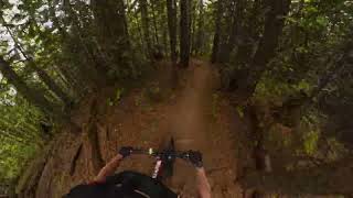
It's pretty unlikely that you would find anyone whose Top 5 in Fernie does not include Brokeback. Bermed switchback after bermed switchback, fun flowy sections all on buffed single track with a few option dirt launches. Do it

Access Info

Either ride up Hedonism and straight across the powerline and up the bottom of the S Bomb. About 10 minutes up here (all rideable up), on the left, is a big wooden sign for Brokeback Ridge.

Alternatively switch onto this as you come down S Bomb.

Local Trail Association
Traditionally Indigenous Territory

Recent Activity on Trail

Past Week
  • 5 rides
  • 18.4 km average
6 Months
  • 40 rides
  • 20.1 km avg distance
All
  • 860 rides
  • Last: Jun 17, 2026
c1c2c3c4
January
February
March
April
May
June
July
August
September
October
November
December
update trails status or condition

Brokeback Ridge Trail Reports

statusdatedescription
May 10, 2026 @ 7:16am (America/Creston)
May 10, 2026
reporter
May 7, 2026 @ 4:33pm (America/Edmonton)
May 7, 2026
reporter A few patches of snow/mud before the powerline. Dry below powerline
Mar 30, 2026 @ 11:46am (America/Edmonton)
Mar 30, 2026
Sep 13, 2025 @ 11:28am (America/Creston)
Sep 13, 2025
Aug 19, 2025 @ 6:35pm
Aug 19, 2025
Moose hanging out at the power lines- evening of August 19
more »
Status:
on May 10, 2026
Variable
Avg: 4.35 (49 votes)
Your vote: 0

view (5,083)
close
3D
Trail Conditions
  • Unknown
  • Snow Groomed
  • Snow Packed
  • Snow Covered
  • Snow Cover Partial
  • Freeze/thaw Cycle
  • Icy
  • Prevalent Mud
  • Wet
  • Variable
  • Ideal
  • Dry
  • Very Dry
Trail Flow (Ridden Direction)
Trailforks scans users ridelogs to determine the most popular direction each trail is ridden. A good flowing trail network will have most trails flowing in a single direction according to their intension.
The colour categories are based on what percentage of riders are riding a trail in its intended direction.
  • > 96%
  • > 90%
  • > 80%
  • > 70%
  • > 50%
  • < 50%
  • bi-directional trail
  • no data
Trail Last Ridden
Trailforks scans ridelogs to determine the last time a trail was ridden.
  • < 2 days
  • < 1 week
  • < 2 weeks
  • < 1 month
  • < 6 months
  • > 6 months
Trail Ridden Direction
The intended direction a trail should be ridden.
  • Downhill Only
  • Downhill Primary
  • Both Directions
  • Uphill Primary
  • Uphill Only
  • One Direction
Contribute Details
Colors indicate trail is missing specified detail.
  • Description
  • Photos
  • Description & Photos
  • Videos
Trail Popularity ?
Trailforks scans ridelogs to determine which trails are ridden the most in the last 9 months. Trails are compared with nearby trails in the same city region with a possible 25 colour shades. Think of this as a heatmap, more rides = more kinetic energy = warmer colors.
  • most popular
  • popular
  • less popular
  • not popular
ATV/ORV/OHV Filter
Max Vehicle Width
inches
US Cell Coverage
Legend
cell carrier legend

Radar Time
Activity Recordings
Trailforks uses anonymized public activity data. ?
Activity Recordings
Trailforks uses anonymized public activity data. ?
Personal Heatmap
Activity Types
all / none
Options
2
Date range month
Winter Trails
Warning A routing network for winter maps does not exist. Selecting trails using the winter trails layer has been disabled.
Missing Trails
Most Popular
Least Popular
Trails are colored based on popularity. The more popular a trail is, the more red. Less popular trails trend towards green.
Jump Magnitude Heatmap
Heatmap of where riders jump on trails. Zoom in to see individual jumps, click circles to view jump details.
BC Backroad Status

Service Road Atlas is a free to use, community-driven service for viewing and creating reports on the numerous back-country service roads around B.C. and Alberta.

map legend
Slope Aspect
Direction the slope faces
Flat N NE E SE S SW W NW
Trails Deemphasized
Trails are shown in grey.
disable
Only show trails with no bike usage.
Enable
Suggested Layers
Based on selected activity type

    Save the current map location and zoom level as your default home location whenever this page is loaded.

    Save
        Directions to brokeback-ridge trailhead (49.508730, -115.109820)

        Photos

        21 more »
        43 |
        Jun 13, 2024 @ 3:15pm
        Jun 13, 2024
        135 |
        May 28, 2023 @ 6:50am
        May 28, 2023
        119 |
        May 28, 2023 @ 6:49am
        May 28, 2023
        341 |
        Feb 3, 2021 @ 5:52pm
        Feb 3, 2021

        Videos

        6 more »
        Slunt (S Bomb) + Brokeback Ridge - Fernie
        10:38 | 166 | Apr 25, 2025 , Fernie
        Brokeback Ridge, Fernie BC
        6:01 | 284 | Jun 7, 2024 , Fernie
        Brokeback Ridge - Fernie
        7:55 | 618 | Jul 6, 2021 , Fernie
        Verboten and Brokeback Ridge
        9:13 | 373 | Dec 17, 2020 , Fernie

        Routes with this trail

        5.0 5 miles 1,800 ft 10 Point to Point
        How to find it The trail starts from the top of Lactic Ridge, which is accessed from the top of Mushroom...
        5.0 5 miles 1,683 ft 18
        Phat Bastard, Mushroom Head, Lactic Ridge, Moc Assassin, Stupid Traverse, Slunt (S-Bomb) and Brokeback....
        4.0 30 miles 6,600 ft 62
        Here we have the 2018 Fernie Mountain Bike Club High Roller Route!

        10 Reviews & Comments


        We hope you've been enjoying Trailforks!

        Create a FREE account to view trail comments and much more.

        • By barry-mclane & contributors
        • #28440 - 8,830 views

        Frequently Asked Questions About Brokeback Ridge

        Where is Brokeback Ridge located?
        Brokeback Ridge is located in Mount Fernie Provincial Park, Fernie, British Columbia, Canada. It is part of the Mount Fernie Provincial Park trail network. The trailhead is located at coordinates 49.50873, -115.10982.
        How hard is Brokeback Ridge?
        Brokeback Ridge is rated as Black Diamond difficulty. The average grade is 11.9%.
        What is the elevation gain for Brokeback Ridge?
        The trail has 919 ft of elevation descent. The elevation ranges from 3,456 ft to 4,375 ft.
        Is Brokeback Ridge a point to point trail?
        Yes, Brokeback Ridge is a point to point trail. The direction is Downhill Only. The trail type is singletrack.

        Hit the Trail

        Open in App

        Get this trail on your phone instantly.
        open trail in app

        Download Trail

        Save to wishlist, Garmin & download.
        save the trail

        Find Related Routes

        Find routes and users activities that include this trail.
        find routes for this trail

        You must enter a description before submitting.