more stats
4,757 ft
Distance
-1,075 ft
Descent
00:10:53
Avg time
-1,075 ft
Altitude change
280 ft
Altitude min
1,355 ft
Altitude max
1,355 ft
Altitude start
279 ft
Altitude end
-22.6%
Grade
-54.9%
Grade max
-4.4%
Grade min
4,757 ft
Distance down
00:10:53
Avg time

Broken Axe Details

  • Activities
    • Mountain Bike
    • E-Bike
  • Riding Area
  • Difficulty Rating
  • Local Popularity
    25 in Mountain Biking
  • Global Ranking
    #93150 in Mountain Biking
  • Trail Type
    Singletrack
  • Bike Type
    DH, AM
  • Physical Rating
    Hard
  • Season
    All Year
  • Dogs Allowed
    Yes
  • eBike Allowed
    Yes up to Class 1
  • TTFs on Trail
    Drop, Jump

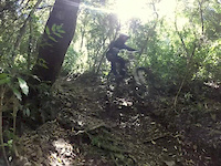
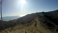
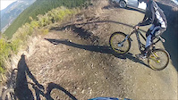
Super fun, fast and loose with the a few techie sections thrown in. Starting high on Kaka ridge with views over Nelson and the Maitai, the trail drops across open country with step downs and rollers before entering the pine forest with loose rock and roots and a super fast flowy finish. Good times on AM and DH bikes alike. New trail grade in 2021.

Access Info

This trail is maintained by the Nelson Mountain Bike Club. Please consider supporting the club.

Recent Activity on Trail

Past Week
  • 0 rides
  •  
6 Months
  • 0 rides
  •  
All
  • 10 rides
  • Last: Apr 25, 2026
c1c2c3c4
January
February
March
April
May
June
July
August
September
October
November
December
update trails status or condition

Broken Axe Trail Reports

statusdatedescription
Jan 5, 2026 @ 1:50pm (Pacific/Auckland)
Jan 4, 2026
reporter Closed due to a large number of trees down. Please avoid this area.
Oct 10, 2025 @ 6:47pm (Pacific/Auckland)
Oct 9, 2025
reporter Open for recreational access
Jul 31, 2025 @ 11:17pm
Jul 31, 2025
reporter
Jul 28, 2025 @ 2:17pm
Jul 28, 2025
reporter TPFL Forests closed due to weather warning
May 26, 2025 @ 2:41pm
May 26, 2025
reporter Only open on weekends via Kaka Road
more »
Status:
on Jan 5, 2026
Dry
Avg: 4.08 (5 votes)
Your vote: 0

view (486)
close
3D
Trail Conditions
  • Unknown
  • Snow Groomed
  • Snow Packed
  • Snow Covered
  • Snow Cover Partial
  • Freeze/thaw Cycle
  • Icy
  • Prevalent Mud
  • Wet
  • Variable
  • Ideal
  • Dry
  • Very Dry
Trail Flow (Ridden Direction)
Trailforks scans users ridelogs to determine the most popular direction each trail is ridden. A good flowing trail network will have most trails flowing in a single direction according to their intension.
The colour categories are based on what percentage of riders are riding a trail in its intended direction.
  • > 96%
  • > 90%
  • > 80%
  • > 70%
  • > 50%
  • < 50%
  • bi-directional trail
  • no data
Trail Last Ridden
Trailforks scans ridelogs to determine the last time a trail was ridden.
  • < 2 days
  • < 1 week
  • < 2 weeks
  • < 1 month
  • < 6 months
  • > 6 months
Trail Ridden Direction
The intended direction a trail should be ridden.
  • Downhill Only
  • Downhill Primary
  • Both Directions
  • Uphill Primary
  • Uphill Only
  • One Direction
Contribute Details
Colors indicate trail is missing specified detail.
  • Description
  • Photos
  • Description & Photos
  • Videos
Trail Popularity ?
Trailforks scans ridelogs to determine which trails are ridden the most in the last 9 months. Trails are compared with nearby trails in the same city region with a possible 25 colour shades. Think of this as a heatmap, more rides = more kinetic energy = warmer colors.
  • most popular
  • popular
  • less popular
  • not popular
ATV/ORV/OHV Filter
Max Vehicle Width
inches
US Cell Coverage
Legend
cell carrier legend

Radar Time
Activity Recordings
Trailforks uses anonymized public activity data. ?
Activity Recordings
Trailforks uses anonymized public activity data. ?
Personal Heatmap
Activity Types
all / none
Options
2
Date range month
Winter Trails
Warning A routing network for winter maps does not exist. Selecting trails using the winter trails layer has been disabled.
Missing Trails
Most Popular
Least Popular
Trails are colored based on popularity. The more popular a trail is, the more red. Less popular trails trend towards green.
Jump Magnitude Heatmap
Heatmap of where riders jump on trails. Zoom in to see individual jumps, click circles to view jump details.
BC Backroad Status

Service Road Atlas is a free to use, community-driven service for viewing and creating reports on the numerous back-country service roads around B.C. and Alberta.

map legend
Slope Aspect
Direction the slope faces
Flat N NE E SE S SW W NW
Trails Deemphasized
Trails are shown in grey.
disable
Only show trails with no bike usage.
Enable
Suggested Layers
Based on selected activity type

    Save the current map location and zoom level as your default home location whenever this page is loaded.

    Save
        Directions to broken-axe-38386 trailhead (-41.262340, 173.329410)

        Photos

        63 more »
        204 |
        Jun 6, 2016 @ 3:57am
        Jun 6, 2016
        176 |
        Jun 6, 2016 @ 3:57am
        Jun 6, 2016
        219 |
        Jun 6, 2016 @ 3:57am
        Jun 6, 2016
        211 |
        Feb 2, 2016 @ 3:23pm
        Feb 2, 2016

        Videos

        4 more »
        Winter DH series round 1
        5:03 | 445 | Jul 17, 2016 , Nelson
        rocks&roots
        0:06 | 251 | Nov 28, 2014 , Nelson
        broken axe small edit
        0:42 | 417 | Jul 19, 2015 , Nelson
        Broken axe
        4:09 | 831 | Jul 19, 2014 , Nelson

        Reviews / Comments

        No reviews yet, be the first to write a review or ask a question.
        Use trail reports to comment on trail conditions.


        We hope you've been enjoying Trailforks!

        Create a FREE account to view trail comments and much more.

        • By NMTBCTF Pro NMTBC & contributors
        • #38386 - 5,979 views

        Frequently Asked Questions About Broken Axe

        Where is Broken Axe located?
        Broken Axe is located in Waitarake/Sharlands, Nelson, New Zealand. It is part of the Waitarake/Sharlands trail network. The trailhead is located at coordinates -41.26234, 173.32941.
        How hard is Broken Axe?
        Broken Axe is rated as Double Black Diamond difficulty. The physical rating is Hard. The average grade is 22.6%.
        What is the elevation gain for Broken Axe?
        The trail has 1,075 ft of elevation descent. The elevation ranges from 280 ft to 1,355 ft.
        How long is Broken Axe?
        Broken Axe is 4,757 ft long. The trail type is singletrack.

        Hit the Trail

        Open in App

        Get this trail on your phone instantly.
        open trail in app

        Download Trail

        Save to wishlist, Garmin & download.
        save the trail

        Find Related Routes

        Find routes and users activities that include this trail.
        find routes for this trail

        You must enter a description before submitting.