more stats
2.5 miles
Distance
102 ft
Climb
-1,667 ft
Descent
00:31:53
Avg time
-1,565 ft
Altitude change
611 ft
Altitude min
2,257 ft
Altitude max
2,176 ft
Altitude start
610 ft
Altitude end
-12%
Grade
-46%
Grade max
20.1%
Grade min
1,480 ft
Distance climb
2 miles
Distance down
636 ft
Distance flat
00:31:53
Avg time

Brown Pow Details

  • Activities
    • Mountain Bike
  • Riding Area
    Lake Whatcom Park
    Bellingham, Washington
  • Difficulty Rating
  • Voted Difficulty
    Black Diamond (8 votes)
  • Local Popularity
    75 in Mountain Biking
  • Global Ranking
    #26117 in Mountain Biking
  • Trail Type
    Singletrack
  • Bike Type
    DH, AM
  • Direction
    Downhill Only
    Popular Direction Shown
  • Climb Difficulty
    Black Diamond
  • Physical Rating
    Hard
  • Trail Visibility
    Always easy to follow
  • Dogs Allowed
    Yes
  • eBike Allowed
  • TTFs on Trail
    Bridge, Gap Jump
  • Ride in Rain
    Yes
  • Year Opened
    2019

No community description for Brown Pow trail has been added yet!

AI Generated Description

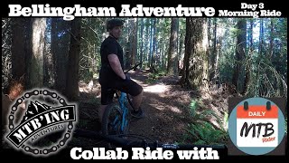
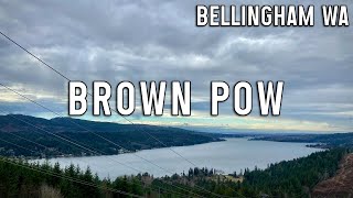
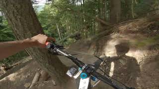
Brown Pow is a highly rated 2 mile popular black diamond difficulty singletrack trail located near Bellingham Washington. This mountain bike only trail can be used downhill only and has a hard overall physical rating with a 102 ft black diamond climb. It features bridge and gap jump. Trail visibility is always easy to follow. On average it takes 31 minutes to complete this trail.

Access Info

Climb up the new Chanterelle climbing trail to the viewpoint. Then take the left into the upper Chanterelle trail. Follow that to the turnoff that takes you under the power lines and cross the Wickersham Truck Trail road. Follow the access road and find the entrance to the top of Brown Pow on your left.

Disclaimer

Respect the trail, trail builders and the property.

Trail Supporters
Local Trail Association
Traditionally Indigenous Territory

Recent Activity on Trail

Past Week
  • 7 rides
  • 8 miles average
6 Months
  • 50 rides
  • 9 miles avg distance
All
  • 522 rides
  • Last: Jun 15, 2026
c1c2c3c4
January
February
March
April
May
June
July
August
September
October
November
December
update trails status or condition

Brown Pow Trail Reports

statusdatedescription
May 28, 2026 @ 3:36pm (America/Los_Angeles)
May 28, 2026
Lower section needs brushing.
May 18, 2026 @ 4:30pm (America/Vancouver)
May 18, 2026
Apr 15, 2026 @ 7:50pm (America/Los_Angeles)
Apr 15, 2026
reporter
Tree is cleared.
Apr 10, 2026 @ 12:53pm (America/Los_Angeles)
Apr 10, 2026
Tree down about two switchbacks before the second drop. Easy to step over with bike and on an easier section of trail so not a big deal.
Apr 7, 2026 @ 1:43pm (America/Los_Angeles)
Apr 7, 2026
reporter
Trees are cleared!
more »
Status:
on May 28, 2026
Ideal
Avg: 4.28 (41 votes)
Your vote: 0

view (3,398)
close
3D
Trail Conditions
  • Unknown
  • Snow Groomed
  • Snow Packed
  • Snow Covered
  • Snow Cover Partial
  • Freeze/thaw Cycle
  • Icy
  • Prevalent Mud
  • Wet
  • Variable
  • Ideal
  • Dry
  • Very Dry
Trail Flow (Ridden Direction)
Trailforks scans users ridelogs to determine the most popular direction each trail is ridden. A good flowing trail network will have most trails flowing in a single direction according to their intension.
The colour categories are based on what percentage of riders are riding a trail in its intended direction.
  • > 96%
  • > 90%
  • > 80%
  • > 70%
  • > 50%
  • < 50%
  • bi-directional trail
  • no data
Trail Last Ridden
Trailforks scans ridelogs to determine the last time a trail was ridden.
  • < 2 days
  • < 1 week
  • < 2 weeks
  • < 1 month
  • < 6 months
  • > 6 months
Trail Ridden Direction
The intended direction a trail should be ridden.
  • Downhill Only
  • Downhill Primary
  • Both Directions
  • Uphill Primary
  • Uphill Only
  • One Direction
Contribute Details
Colors indicate trail is missing specified detail.
  • Description
  • Photos
  • Description & Photos
  • Videos
Trail Popularity ?
Trailforks scans ridelogs to determine which trails are ridden the most in the last 9 months. Trails are compared with nearby trails in the same city region with a possible 25 colour shades. Think of this as a heatmap, more rides = more kinetic energy = warmer colors.
  • most popular
  • popular
  • less popular
  • not popular
ATV/ORV/OHV Filter
Max Vehicle Width
inches
US Cell Coverage
Legend
cell carrier legend

Radar Time
Activity Recordings
Trailforks uses anonymized public activity data. ?
Activity Recordings
Trailforks uses anonymized public activity data. ?
Personal Heatmap
Activity Types
all / none
Options
2
Date range month
Winter Trails
Warning A routing network for winter maps does not exist. Selecting trails using the winter trails layer has been disabled.
Missing Trails
Most Popular
Least Popular
Trails are colored based on popularity. The more popular a trail is, the more red. Less popular trails trend towards green.
Jump Magnitude Heatmap
Heatmap of where riders jump on trails. Zoom in to see individual jumps, click circles to view jump details.
BC Backroad Status

Service Road Atlas is a free to use, community-driven service for viewing and creating reports on the numerous back-country service roads around B.C. and Alberta.

map legend
Slope Aspect
Direction the slope faces
Flat N NE E SE S SW W NW
Trails Deemphasized
Trails are shown in grey.
disable
Only show trails with no bike usage.
Enable
Suggested Layers
Based on selected activity type

    Save the current map location and zoom level as your default home location whenever this page is loaded.

    Save
        Directions to brown-pow trailhead (48.722830, -122.276830)

        Photos

        69 more »
        727 |
        Jul 18, 2020 @ 9:47pm
        Jul 18, 2020
        902 |
        Jan 2, 2020 @ 6:14pm
        Jan 2, 2020
        81 |
        Nov 29, 2025 @ 5:11pm
        Nov 29, 2025
        369 |
        May 8, 2024 @ 7:17am
        May 8, 2024

        Videos

        15 more »
        youtuber Bellingham Adventure - Day 3 (Morning Ride)...
        16:22 | 1388 | Aug 28, 2020 , Bellingham
        youtuber Bellingham Brown Pow!
        14:16 | 867 | Feb 2, 2024 , Bellingham
        Brown Pow.....Maybe just brown
        14:00 | 392 | Aug 7, 2023 , Bellingham
        The Steepest Sanctioned Loamer In The PNW???...
        397 | Jan 16, 2023 , Bellingham

        Trail Lists

        Trail Events

        20 Reviews & Comments


        We hope you've been enjoying Trailforks!

        Create a FREE account to view trail comments and much more.

        Frequently Asked Questions About Brown Pow

        Where is Brown Pow located?
        Brown Pow is located in Lake Whatcom Park, Bellingham, Washington, United States. It is part of the Lake Whatcom Park trail network. The trailhead is located at coordinates 48.72283, -122.27683.
        How hard is Brown Pow?
        Brown Pow is rated as Black Diamond difficulty. The physical rating is Hard. The average grade is 12%. The climb difficulty is rated Black Diamond.
        What is the elevation gain for Brown Pow?
        Brown Pow has 102 ft of elevation gain. The trail has 1,667 ft of elevation descent. The elevation ranges from 611 ft to 2,257 ft.
        Is Brown Pow a point to point trail?
        Yes, Brown Pow is a point to point trail. The direction is Downhill Only. The trail type is singletrack.

        Hit the Trail

        Open in App

        Get this trail on your phone instantly.
        open trail in app

        Download Trail

        Save to wishlist, Garmin & download.
        save the trail

        Find Related Routes

        Find routes and users activities that include this trail.
        find routes for this trail

        You must enter a description before submitting.