more stats
1.8 miles
Distance
58 ft
Climb
-400 ft
Descent
00:17:24
Avg time
-342 ft
Altitude change
5,424 ft
Altitude min
5,765 ft
Altitude max
5,765 ft
Altitude start
5,423 ft
Altitude end
-3.7%
Grade
-24.4%
Grade max
14.6%
Grade min
1,683 ft
Distance climb
1 mile
Distance down
653 ft
Distance flat
00:17:24
Avg time

Bull Run Details

  • Activities
    • Mountain Bike
    • E-Bike
    • Adaptive Bike
    • Hike
    • Trail Running
  • Riding Area
    Mag 7
    Moab, Utah
  • Difficulty Rating
  • Voted Difficulty
    Black Diamond (6 votes)
  • Local Popularity
    95 in Mountain Biking [+]
    • 95 in Trail Running
    • 80 in Hiking
  • Global Ranking
    #1249 in Mountain Biking [+]
    • #484 in Trail Running
    • #7210 in Hiking
  • Trail Type
    Singletrack
  • Bike Type
  • Dogs Allowed
    Yes
  • eBike Allowed
    Yes up to Class 1
  • Land Owner
    BLM

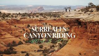
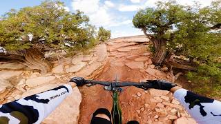
Outstanding trail, mixed riding on rock and dirt, playful flow, intermediate technical. Excellent views of Bull Canyon as you ride along the rim, and the LaSal mountains and Arches to the east.
NOTE: trail has high-speed downhill traffic, and is designed as a downhill only route.

Disclaimer

One way downhill trail

Adaptive Bike Info
aMTB Black Rating: Advanced obstacles exist, some trail obstructions.

A lot of off-camber as the trail crosses the canyon face and four or five rock crawls requiring assistance for most adaptive riders

Trail Supporters
Local Trail Association
Traditionally Indigenous Territory

Recent Activity on Trail

Past Week
  • 1 rides
  • 13 miles average
6 Months
  • 240 rides
  • 20 miles avg distance
All
  • 2,001 rides
  • Last: Jun 20, 2026
c1c2c3c4
January
February
March
April
May
June
July
August
September
October
November
December
Status:
on May 19, 2026
Ideal
Avg: 4.66 (84 votes)
Your vote: 0

view (11,497)
close
3D
Trail Conditions
  • Unknown
  • Snow Groomed
  • Snow Packed
  • Snow Covered
  • Snow Cover Partial
  • Freeze/thaw Cycle
  • Icy
  • Prevalent Mud
  • Wet
  • Variable
  • Ideal
  • Dry
  • Very Dry
Trail Flow (Ridden Direction)
Trailforks scans users ridelogs to determine the most popular direction each trail is ridden. A good flowing trail network will have most trails flowing in a single direction according to their intension.
The colour categories are based on what percentage of riders are riding a trail in its intended direction.
  • > 96%
  • > 90%
  • > 80%
  • > 70%
  • > 50%
  • < 50%
  • bi-directional trail
  • no data
Trail Last Ridden
Trailforks scans ridelogs to determine the last time a trail was ridden.
  • < 2 days
  • < 1 week
  • < 2 weeks
  • < 1 month
  • < 6 months
  • > 6 months
Trail Ridden Direction
The intended direction a trail should be ridden.
  • Downhill Only
  • Downhill Primary
  • Both Directions
  • Uphill Primary
  • Uphill Only
  • One Direction
Contribute Details
Colors indicate trail is missing specified detail.
  • Description
  • Photos
  • Description & Photos
  • Videos
Trail Popularity ?
Trailforks scans ridelogs to determine which trails are ridden the most in the last 9 months. Trails are compared with nearby trails in the same city region with a possible 25 colour shades. Think of this as a heatmap, more rides = more kinetic energy = warmer colors.
  • most popular
  • popular
  • less popular
  • not popular
ATV/ORV/OHV Filter
Max Vehicle Width
inches
US Cell Coverage
Legend
cell carrier legend

Radar Time
Activity Recordings
Trailforks uses anonymized public activity data. ?
Activity Recordings
Trailforks uses anonymized public activity data. ?
Personal Heatmap
Activity Types
all / none
Options
2
Date range month
Winter Trails
Warning A routing network for winter maps does not exist. Selecting trails using the winter trails layer has been disabled.
Missing Trails
Most Popular
Least Popular
Trails are colored based on popularity. The more popular a trail is, the more red. Less popular trails trend towards green.
Jump Magnitude Heatmap
Heatmap of where riders jump on trails. Zoom in to see individual jumps, click circles to view jump details.
BC Backroad Status

Service Road Atlas is a free to use, community-driven service for viewing and creating reports on the numerous back-country service roads around B.C. and Alberta.

map legend
Slope Aspect
Direction the slope faces
Flat N NE E SE S SW W NW
Trails Deemphasized
Trails are shown in grey.
disable
Only show trails with no bike usage.
Enable
Suggested Layers
Based on selected activity type

    Save the current map location and zoom level as your default home location whenever this page is loaded.

    Save
        Directions to bull-run trailhead (38.582000, -109.776130)

        Photos

        37 more »
        1,067 |
        Jun 3, 2013 @ 2:34pm
        Jun 3, 2013
        919 |
        Feb 19, 2014 @ 9:42pm
        Feb 19, 2014
        5 |
        May 20, 2026 @ 1:48pm
        May 20, 2026
        5 |
        May 20, 2026 @ 1:47pm
        May 20, 2026

        Videos

        15 more »
        That's what mountain biking feels like only in...
        20:48 | 52 | Mar 28, 2026 , Moab
        MTB Rookie on a BLACK DIAMOND - BULL RUN in Moab
        20:55 | 225 | May 4, 2025 , Moab
        Trainer Fodder Tuesday: Moab rocks XC MTB race...
        51:02 | 111 | Feb 11, 2025 , Moab
        Bull Run - Moab, UT
        177 | Dec 7, 2024 , Moab

        Trail Lists

        Routes with this trail

        4.8 18 miles 1,410 ft 10 Loop
        Loop some of the most scenic sections of Mag 7 in a way that limits how much climbing one has to endure....
        4.4 21 miles 1,779 ft 19 Shuttled
        This is the Mag 7 ride, named after the 7 trails it includes. There are alternate routes but this one is...
        4.4 16 miles 647 ft 11 Shuttled
        The Mag 5 ride is an awesome shuttle. The terrain is fairly intermediate and not super steep either....

        10 Reviews & Comments


        We hope you've been enjoying Trailforks!

        Create a FREE account to view trail comments and much more.

        • By toddTF Pro Trailforks & contributors
        • #8785 - 18,063 views

        Frequently Asked Questions About Bull Run

        Where is Bull Run located?
        Bull Run is located in Mag 7, Moab, Utah, United States. It is part of the Mag 7 trail network. The trailhead is located at coordinates 38.582, -109.77613.
        How hard is Bull Run?
        Bull Run is rated as Black Diamond difficulty. The average grade is 3.7%.
        What is the elevation gain for Bull Run?
        Bull Run has 58 ft of elevation gain. The trail has 400 ft of elevation descent. The elevation ranges from 5,424 ft to 5,765 ft.
        How long is Bull Run?
        Bull Run is 1.8 miles long. The trail type is singletrack.

        Hit the Trail

        Open in App

        Get this trail on your phone instantly.
        open trail in app

        Download Trail

        Save to wishlist, Garmin & download.
        save the trail

        Find Related Routes

        Find routes and users activities that include this trail.
        find routes for this trail

        You must enter a description before submitting.