more stats
1.9 miles
Distance
294 ft
Climb
-148 ft
Descent
00:21:55
Avg time
144 ft
Altitude change
2,374 ft
Altitude min
2,552 ft
Altitude max
2,375 ft
Altitude start
2,520 ft
Altitude end
1.5%
Grade
-17.7%
Grade max
16.8%
Grade min
1 mile
Distance climb
3,048 ft
Distance down
1,135 ft
Distance flat
00:21:55
Avg time

Bus Jaune Details

  • Activities
    • Mountain Bike
    • E-Bike
  • Riding Area
    Le Massif de Charlevoix
    Petite-Rivière-Saint-François, Quebec
  • Difficulty Rating
  • Voted Difficulty
    Green (1 vote)
  • Local Popularity
    70 in Mountain Biking [+]
    • 80 in E-Biking
  • Global Ranking
    #44982 in Mountain Biking [+]
    • #11446 in E-Biking
  • Trail Type
    Machine Groomed
  • Bike Type
    AM, XC
  • Direction
    Downhill Only
    Popular Direction Shown
  • Climb Difficulty
    Blue
  • Physical Rating
    Moderate
  • Trail Visibility
    Always easy to follow
  • Season
    juin à octobre
  • eBike Allowed
    Yes up to Class 1
  • TTFs on Trail
    Berm, Bridge
  • Year Opened
    2019
  • Land Owner

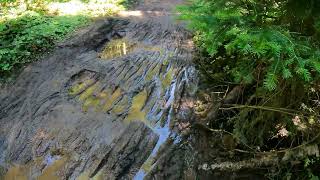
À l'origine, c'est un autobus scolaire qui remontait les skieurs au Massif
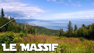
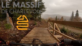
Premier sentier de vélo à avoir été construit au Massif, Bus jaune est une douce montée vers le Mont à Liguori et offre parmi les plus beaux panoramas de la montagne.

Back in the days, an old school bus would get skiers back to the top at Le Massif!
The first bike trail to be built at Le Massif, Bus jaune (yellow bus) is an easy climbing trail towards the top of Mont à Liguori and has many of the best views on the mountain.

Trail Supporters

Bike Park

Local Trail Association
Traditionally Indigenous Territory

Recent Activity on Trail

Past Week
  • 0 rides
  •  
6 Months
  • 0 rides
  •  
All
  • 583 rides
  • Last: Jul 5, 2023
c1c2c3c4
January
February
March
April
May
June
July
August
September
October
November
December
update trails status or condition

Bus Jaune Trail Reports

Status:
on Jan 6, 2025
Avg: 3.29 (18 votes)
Your vote: 0

view (3,043)
close
3D
Trail Conditions
  • Unknown
  • Snow Groomed
  • Snow Packed
  • Snow Covered
  • Snow Cover Partial
  • Freeze/thaw Cycle
  • Icy
  • Prevalent Mud
  • Wet
  • Variable
  • Ideal
  • Dry
  • Very Dry
Trail Flow (Ridden Direction)
Trailforks scans users ridelogs to determine the most popular direction each trail is ridden. A good flowing trail network will have most trails flowing in a single direction according to their intension.
The colour categories are based on what percentage of riders are riding a trail in its intended direction.
  • > 96%
  • > 90%
  • > 80%
  • > 70%
  • > 50%
  • < 50%
  • bi-directional trail
  • no data
Trail Last Ridden
Trailforks scans ridelogs to determine the last time a trail was ridden.
  • < 2 days
  • < 1 week
  • < 2 weeks
  • < 1 month
  • < 6 months
  • > 6 months
Trail Ridden Direction
The intended direction a trail should be ridden.
  • Downhill Only
  • Downhill Primary
  • Both Directions
  • Uphill Primary
  • Uphill Only
  • One Direction
Contribute Details
Colors indicate trail is missing specified detail.
  • Description
  • Photos
  • Description & Photos
  • Videos
Trail Popularity ?
Trailforks scans ridelogs to determine which trails are ridden the most in the last 9 months. Trails are compared with nearby trails in the same city region with a possible 25 colour shades. Think of this as a heatmap, more rides = more kinetic energy = warmer colors.
  • most popular
  • popular
  • less popular
  • not popular
ATV/ORV/OHV Filter
Max Vehicle Width
inches
US Cell Coverage
Legend
cell carrier legend

Radar Time
Activity Recordings
Trailforks uses anonymized public activity data. ?
Activity Recordings
Trailforks uses anonymized public activity data. ?
Personal Heatmap
Activity Types
all / none
Options
2
Date range month
Winter Trails
Warning A routing network for winter maps does not exist. Selecting trails using the winter trails layer has been disabled.
Missing Trails
Most Popular
Least Popular
Trails are colored based on popularity. The more popular a trail is, the more red. Less popular trails trend towards green.
Jump Magnitude Heatmap
Heatmap of where riders jump on trails. Zoom in to see individual jumps, click circles to view jump details.
BC Backroad Status

Service Road Atlas is a free to use, community-driven service for viewing and creating reports on the numerous back-country service roads around B.C. and Alberta.

map legend
Slope Aspect
Direction the slope faces
Flat N NE E SE S SW W NW
Trails Deemphasized
Trails are shown in grey.
disable
Only show trails with no bike usage.
Enable
Suggested Layers
Based on selected activity type

    Save the current map location and zoom level as your default home location whenever this page is loaded.

    Save
        Directions to bus-jaune trailhead (47.279820, -70.610630)

        Photos

        11 more »
        337 |
        Aug 28, 2020 @ 1:23pm
        Aug 28, 2020
        389 |
        Aug 28, 2020 @ 1:23pm
        Aug 28, 2020
        215 |
        Jun 10, 2022 @ 7:46am
        Jun 10, 2022
        313 |
        Oct 13, 2021 @ 12:14pm
        Oct 13, 2021

        Videos

        3 more »
        L'autobus Jaune avec Caro
        23:21 | 145 | Aug 25, 2023 , Petite-Rivière-Saint-François
        EXPLORING LE MASSIF//QUEBEC//2022//The best...
        1:23:02 | 205 | Sep 5, 2022 , Petite-Rivière-Saint-François
        youtuber Le Massif De Charlevoix - Une Toute Nouvelle...
        15:28 | 1062 | Sep 3, 2020 , Petite-Rivière-Saint-François

        Routes with this trail

        4.0 7 miles 367 ft 3 Point to Point
        This has to be the longest downhill run east of the rockies! Quite accessible with countless berms and...
        5.0 5 miles 307 ft 5
        Le grand tour du Massif, par les sentiers et Histoire sans fin. Montée tranquille par vers le Mont...
        7 miles 312 ft 3 Race
        Déjà reconnue comme la destination de ski alpin la plus spectaculaire dans l’est du continent, le...

        1 Review & Comments


        We hope you've been enjoying Trailforks!

        Create a FREE account to view trail comments and much more.

        • By LeMassif & contributors
        • #231551 - 1,838 views

        Frequently Asked Questions About Bus Jaune

        Where is Bus Jaune located?
        Bus Jaune is located in Le Massif de Charlevoix, Petite-Rivière-Saint-François, Quebec, Canada. It is part of the Le Massif de Charlevoix trail network. The trailhead is located at coordinates 47.27982, -70.61063.
        How hard is Bus Jaune?
        Bus Jaune is rated as Blue difficulty. The physical rating is Moderate. The average grade is 1.5%. The climb difficulty is rated Blue.
        What is the elevation gain for Bus Jaune?
        Bus Jaune has 90 m of elevation gain. The trail has 45 m of elevation descent. The elevation ranges from 724 m to 778 m.
        Is Bus Jaune a point to point trail?
        Yes, Bus Jaune is a point to point trail. The direction is Downhill Only. The trail type is machine groomed.

        Hit the Trail

        Open in App

        Get this trail on your phone instantly.
        open trail in app

        Download Trail

        Save to wishlist, Garmin & download.
        save the trail

        Find Related Routes

        Find routes and users activities that include this trail.
        find routes for this trail

        You must enter a description before submitting.