more stats
889 ft
Distance
-112 ft
Descent
00:01:32
Avg time
-112 ft
Altitude change
1,288 ft
Altitude min
1,401 ft
Altitude max
1,401 ft
Altitude start
1,289 ft
Altitude end
-12.6%
Grade
-50.9%
Grade max
-3%
Grade min
889 ft
Distance down
00:01:32
Avg time

Bushwack Details

  • Activities
    • Mountain Bike
  • Riding Area
    Mountain Creek Resort
    Vernon, New Jersey
  • Difficulty Rating
  • Voted Difficulty
    Blue (1 vote)
  • Local Popularity
    75 in Mountain Biking
  • Global Ranking
    #56482 in Mountain Biking
  • Trail Type
    Singletrack
  • Bike Type
    DH, AM
  • TTFs on Trail
    Berm, Drop, Rock Face, Rock Garden
  • Land Owner

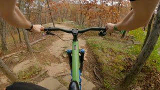
Chunky blue tech trail that connects the lift to the trail hub to the east. This is the technical blue alternative to Outlaw. Bushwack has multiple lines through with rock gardens and rock rolls. There are three main branches to the trail: the most popular leading toward the trails by the lake (Tempest, Retreat, Legion, etc.), another to the north (Stalker, Utah, Asylum, Waterboy), and one that drops you to the service roadww.trailforks.com/trails/service-road-344784/]service road[/L] in between. Bushwack also has lines that connect with Exodus and 99.

Access Info

Directly across from the lift, cross the grass and head left. Sometimes closed for weddings and other events.

Bike Park

Traditionally Indigenous Territory

Recent Activity on Trail

Past Week
  • 13 rides
  • 22 miles average
6 Months
  • 94 rides
  • 23 miles avg distance
All
  • 812 rides
  • Last: Jun 20, 2026
c1c2c3c4
January
February
March
April
May
June
July
August
September
October
November
December
Status:
on Jun 6, 2026
Dry
Avg: 3.84 (7 votes)
Your vote: 0

view (7,870)
close
3D
Trail Conditions
  • Unknown
  • Snow Groomed
  • Snow Packed
  • Snow Covered
  • Snow Cover Partial
  • Freeze/thaw Cycle
  • Icy
  • Prevalent Mud
  • Wet
  • Variable
  • Ideal
  • Dry
  • Very Dry
Trail Flow (Ridden Direction)
Trailforks scans users ridelogs to determine the most popular direction each trail is ridden. A good flowing trail network will have most trails flowing in a single direction according to their intension.
The colour categories are based on what percentage of riders are riding a trail in its intended direction.
  • > 96%
  • > 90%
  • > 80%
  • > 70%
  • > 50%
  • < 50%
  • bi-directional trail
  • no data
Trail Last Ridden
Trailforks scans ridelogs to determine the last time a trail was ridden.
  • < 2 days
  • < 1 week
  • < 2 weeks
  • < 1 month
  • < 6 months
  • > 6 months
Trail Ridden Direction
The intended direction a trail should be ridden.
  • Downhill Only
  • Downhill Primary
  • Both Directions
  • Uphill Primary
  • Uphill Only
  • One Direction
Contribute Details
Colors indicate trail is missing specified detail.
  • Description
  • Photos
  • Description & Photos
  • Videos
Trail Popularity ?
Trailforks scans ridelogs to determine which trails are ridden the most in the last 9 months. Trails are compared with nearby trails in the same city region with a possible 25 colour shades. Think of this as a heatmap, more rides = more kinetic energy = warmer colors.
  • most popular
  • popular
  • less popular
  • not popular
ATV/ORV/OHV Filter
Max Vehicle Width
inches
US Cell Coverage
Legend
cell carrier legend

Radar Time
Activity Recordings
Trailforks uses anonymized public activity data. ?
Activity Recordings
Trailforks uses anonymized public activity data. ?
Personal Heatmap
Activity Types
all / none
Options
2
Date range month
Winter Trails
Warning A routing network for winter maps does not exist. Selecting trails using the winter trails layer has been disabled.
Missing Trails
Most Popular
Least Popular
Trails are colored based on popularity. The more popular a trail is, the more red. Less popular trails trend towards green.
Jump Magnitude Heatmap
Heatmap of where riders jump on trails. Zoom in to see individual jumps, click circles to view jump details.
BC Backroad Status

Service Road Atlas is a free to use, community-driven service for viewing and creating reports on the numerous back-country service roads around B.C. and Alberta.

map legend
Slope Aspect
Direction the slope faces
Flat N NE E SE S SW W NW
Trails Deemphasized
Trails are shown in grey.
disable
Only show trails with no bike usage.
Enable
Suggested Layers
Based on selected activity type

    Save the current map location and zoom level as your default home location whenever this page is loaded.

    Save
        Directions to bushwack trailhead (41.180740, -74.502960)

        Photos

        61 more »
        332 |
        Sep 4, 2012 @ 2:54pm
        Sep 4, 2012
        458 |
        Oct 28, 2012 @ 9:29pm
        Oct 28, 2012
        190 |
        Apr 30, 2018 @ 6:40pm
        Apr 30, 2018
        282 |
        Apr 30, 2018 @ 6:40pm
        Apr 30, 2018

        Videos

        10 more »
        youtuber THE TOUGHEST TRAIL AT MOUNTAIN CREEK | DMLH
        8:42 | 758 | Aug 16, 2020 , Vernon
        Mountain Creek Bike Park / Blue Tech Trails /...
        5:33 | 162 | Nov 12, 2023 , Vernon
        MINI CLIPZ: Bushwhack
        0:34 | 323 | Sep 27, 2018 , Vernon
        Laps with Laura & Heather
        0:58 | 1901 | Apr 3, 2019 , Vernon

        2 Reviews & Comments


        We hope you've been enjoying Trailforks!

        Create a FREE account to view trail comments and much more.

        • By DownhillR3 MCBP & contributors
        • #28534 - 2,710 views

        Frequently Asked Questions About Bushwack

        Where is Bushwack located?
        Bushwack is located in Mountain Creek Resort, Vernon, New Jersey, United States. It is part of the Mountain Creek Resort trail network. The trailhead is located at coordinates 41.18074, -74.50296.
        How hard is Bushwack?
        Bushwack is rated as Blue difficulty. The average grade is 12.6%.
        What is the elevation gain for Bushwack?
        The trail has 112 ft of elevation descent. The elevation ranges from 1,288 ft to 1,401 ft.
        How long is Bushwack?
        Bushwack is 889 ft long. The trail type is singletrack.

        Hit the Trail

        Open in App

        Get this trail on your phone instantly.
        open trail in app

        Download Trail

        Save to wishlist, Garmin & download.
        save the trail

        Find Related Routes

        Find routes and users activities that include this trail.
        find routes for this trail

        You must enter a description before submitting.