more stats
6.1 miles
Distance
976 ft
Climb
-397 ft
Descent
01:21:31
Avg time
580 ft
Altitude change
4,925 ft
Altitude min
5,504 ft
Altitude max
4,925 ft
Altitude start
5,505 ft
Altitude end
1.8%
Grade
-24.7%
Grade max
24.2%
Grade min
4 miles
Distance climb
2 miles
Distance down
2,044 ft
Distance flat
01:21:31
Avg time

Butterknife Details

  • Activities
    • Mountain Bike
    • E-Bike
    • Hike
    • Trail Running
  • Riding Area
    Third Flats
    Grand Junction, Colorado
  • Difficulty Rating
  • Local Popularity
    65 in Mountain Biking [+]
    • 95 in E-Biking
    • 40 in Trail Running
    • 5 in Hiking
  • Global Ranking
    #90099 in Mountain Biking [+]
    • #6723 in E-Biking
    • #120366 in Trail Running
    • #130823 in Hiking
  • Trail Type
    Singletrack
  • Bike Type
    AM
  • Direction
    Both Directions
    Popular In Reverse
  • Climb Difficulty
    Black Diamond
  • Physical Rating
    Hard
  • Dogs Allowed
    Yes
  • eBike Allowed
    Yes up to Class 3
  • Land Owner
    BLM Grand Junction Field Office

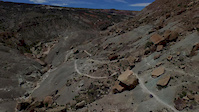
The Butterknife singletrack trail is a motorized, motorcycle trail that was built with state motorized funds and is a great example of a motorized trail that is a great mountain bike trail. Please be aware that you may see motorcycles on the trail, but both user groups happily coexist.

Trail Supporters
  • BLM
    BLM
    Land Manager
Local Trail Association
Traditionally Indigenous Territory

Recent Activity on Trail

Past Week
  • 0 rides
  •  
6 Months
  • 29 rides
  • 25 miles avg distance
All
  • 142 rides
  • Last: Jun 12, 2026
c1c2c3c4
January
February
March
April
May
June
July
August
September
October
November
December
update trails status or condition

Butterknife Trail Reports

statusdatedescription
Mar 21, 2026 @ 8:33am (America/Denver)
Mar 21, 2026
In rough shape! So dry and so much moon dust. Pretty awful really!
Nov 22, 2025 @ 10:55am (America/Denver)
Nov 22, 2025
Trailforks says “No Dirtbikes” and that is 100 percent NOT true. Motorcycles are welcome to ride this trail.
Mar 24, 2025 @ 9:43am
Mar 24, 2025
Very dry and sandy. Could use some moisture.
May 25, 2024 @ 5:57am
May 25, 2024
Mar 26, 2024 @ 12:52pm
Mar 26, 2024
Was in excellent condition on 3/25/24, a day after it rained making the sand that is normally loose very compact and ridable.
more »
Status:
on Mar 21, 2026
Very Dry
Avg: 3.86 (16 votes)
Your vote: 0

view (1,252)
close
3D
Trail Conditions
  • Unknown
  • Snow Groomed
  • Snow Packed
  • Snow Covered
  • Snow Cover Partial
  • Freeze/thaw Cycle
  • Icy
  • Prevalent Mud
  • Wet
  • Variable
  • Ideal
  • Dry
  • Very Dry
Trail Flow (Ridden Direction)
Trailforks scans users ridelogs to determine the most popular direction each trail is ridden. A good flowing trail network will have most trails flowing in a single direction according to their intension.
The colour categories are based on what percentage of riders are riding a trail in its intended direction.
  • > 96%
  • > 90%
  • > 80%
  • > 70%
  • > 50%
  • < 50%
  • bi-directional trail
  • no data
Trail Last Ridden
Trailforks scans ridelogs to determine the last time a trail was ridden.
  • < 2 days
  • < 1 week
  • < 2 weeks
  • < 1 month
  • < 6 months
  • > 6 months
Trail Ridden Direction
The intended direction a trail should be ridden.
  • Downhill Only
  • Downhill Primary
  • Both Directions
  • Uphill Primary
  • Uphill Only
  • One Direction
Contribute Details
Colors indicate trail is missing specified detail.
  • Description
  • Photos
  • Description & Photos
  • Videos
Trail Popularity ?
Trailforks scans ridelogs to determine which trails are ridden the most in the last 9 months. Trails are compared with nearby trails in the same city region with a possible 25 colour shades. Think of this as a heatmap, more rides = more kinetic energy = warmer colors.
  • most popular
  • popular
  • less popular
  • not popular
ATV/ORV/OHV Filter
Max Vehicle Width
inches
US Cell Coverage
Legend
cell carrier legend

Radar Time
Activity Recordings
Trailforks uses anonymized public activity data. ?
Activity Recordings
Trailforks uses anonymized public activity data. ?
Personal Heatmap
Activity Types
all / none
Options
2
Date range month
Winter Trails
Warning A routing network for winter maps does not exist. Selecting trails using the winter trails layer has been disabled.
Missing Trails
Most Popular
Least Popular
Trails are colored based on popularity. The more popular a trail is, the more red. Less popular trails trend towards green.
Jump Magnitude Heatmap
Heatmap of where riders jump on trails. Zoom in to see individual jumps, click circles to view jump details.
BC Backroad Status

Service Road Atlas is a free to use, community-driven service for viewing and creating reports on the numerous back-country service roads around B.C. and Alberta.

map legend
Slope Aspect
Direction the slope faces
Flat N NE E SE S SW W NW
Trails Deemphasized
Trails are shown in grey.
disable
Only show trails with no bike usage.
Enable
Suggested Layers
Based on selected activity type

    Save the current map location and zoom level as your default home location whenever this page is loaded.

    Save
        Directions to butterknife trailhead (39.018060, -108.553290)

        Photos

        2 more »
        584 |
        Aug 1, 2012 @ 11:16pm
        Aug 1, 2012
        541 |
        Aug 1, 2012 @ 11:17pm
        Aug 1, 2012

        Videos

        4 more »
        Butterknife Trail | A Colorado Hidden Gem...
        29:22 | 155 | Apr 28, 2025 , Grand Junction
        Mountain Biking Butterknife, Grand Junction...
        17:49 | 1328 | Jan 22, 2018 , Grand Junction
        2018 Grand Junction Off-Road - 15, 30 or 40...
        3:56 | 105 | Dec 18, 2018 , Grand Junction
        2015 Grand Junction Off-Road
        3:51 | 3592 | Jul 14, 2015 , Grand Junction

        Routes with this trail

        43 miles 5,320 ft 11
        Grand Junction Rides and Vibes Filthy 40 2024 Race Route
        3.0 31 miles 3,459 ft 29 Out & Back
        First itinerary in Grand Junction. Combo of Third Flats' 'Butterknife' and Lunch Loops' ' (east)' down.
        33 miles 3,455 ft 12
        2022 GJ Rides and Vibes dirty 30 course

        6 Reviews & Comments


        We hope you've been enjoying Trailforks!

        Create a FREE account to view trail comments and much more.

        • By toddTF Pro Trailforks & contributors
        • #12135 - 10,294 views

        Frequently Asked Questions About Butterknife

        Where is Butterknife located?
        Butterknife is located in Third Flats, Grand Junction, Colorado, United States. It is part of the Third Flats trail network. The trailhead is located at coordinates 39.01806, -108.55329.
        How hard is Butterknife?
        Butterknife is rated as Black Diamond difficulty. The physical rating is Hard. The average grade is 1.8%. The climb difficulty is rated Black Diamond.
        What is the elevation gain for Butterknife?
        Butterknife has 976 ft of elevation gain. The trail has 397 ft of elevation descent. The elevation ranges from 4,925 ft to 5,504 ft.
        Is Butterknife a point to point trail?
        Butterknife is not a point to point trail. The direction is Both Directions. The trail type is singletrack.

        Hit the Trail

        Open in App

        Get this trail on your phone instantly.
        open trail in app

        Download Trail

        Save to wishlist, Garmin & download.
        save the trail

        Find Related Routes

        Find routes and users activities that include this trail.
        find routes for this trail

        You must enter a description before submitting.