more stats
1.4 miles
Distance
3 ft
Climb
-1,663 ft
Descent
00:14:17
Avg time
-1,659 ft
Altitude change
556 ft
Altitude min
2,216 ft
Altitude max
2,216 ft
Altitude start
558 ft
Altitude end
-23.2%
Grade
-85.2%
Grade max
2.6%
Grade min
112 ft
Distance climb
1 mile
Distance down
154 ft
Distance flat
00:14:17
Avg time

Butters Details

  • Activities
    • Mountain Bike
  • Riding Area
  • Difficulty Rating
  • Voted Difficulty
    Double Black Diamond (1 vote)
  • Local Popularity
    75 in Mountain Biking
  • Global Ranking
    #13511 in Mountain Biking
  • Trail Type
    Singletrack
  • eBike Allowed

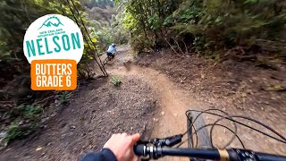
Rooty, rocky, off-camber, all of the very best of Nelson. Start at Te Ara Koa, Fringed Hill and follow the 'Butters' signs. New trail grade in 2021.

Recent Activity on Trail

Past Week
  • 0 rides
  •  
6 Months
  • 31 rides
  • 13 miles avg distance
All
  • 79 rides
  • Last: Jun 19, 2026
c1c2c3c4
January
February
March
April
May
June
July
August
September
October
November
December
update trails status or condition

Butters Trail Reports

statusdatedescription
Jun 8, 2026 @ 6:19pm (Pacific/Auckland)
Jun 7, 2026
tree cleared
Jun 7, 2026 @ 8:00pm (Pacific/Auckland)
Jun 7, 2026
tree across trail just above Bullock spur prior to last switchbacks. Trunk about 1m diam.
May 14, 2026 @ 10:45pm (Pacific/Auckland)
May 14, 2026
Perfect, go for it !
Feb 9, 2026 @ 2:58pm (Pacific/Auckland)
Feb 8, 2026
reporter The tree has been cleared
Feb 9, 2026 @ 1:03pm (Pacific/Auckland)
Feb 8, 2026
reporter Lower section open again. Low hanging tree over the trail on Upper Section.
more »
Status:
on Jun 8, 2026
Avg: 4.45 (8 votes)
Your vote: 0

view (859)
close
3D
Trail Conditions
  • Unknown
  • Snow Groomed
  • Snow Packed
  • Snow Covered
  • Snow Cover Partial
  • Freeze/thaw Cycle
  • Icy
  • Prevalent Mud
  • Wet
  • Variable
  • Ideal
  • Dry
  • Very Dry
Trail Flow (Ridden Direction)
Trailforks scans users ridelogs to determine the most popular direction each trail is ridden. A good flowing trail network will have most trails flowing in a single direction according to their intension.
The colour categories are based on what percentage of riders are riding a trail in its intended direction.
  • > 96%
  • > 90%
  • > 80%
  • > 70%
  • > 50%
  • < 50%
  • bi-directional trail
  • no data
Trail Last Ridden
Trailforks scans ridelogs to determine the last time a trail was ridden.
  • < 2 days
  • < 1 week
  • < 2 weeks
  • < 1 month
  • < 6 months
  • > 6 months
Trail Ridden Direction
The intended direction a trail should be ridden.
  • Downhill Only
  • Downhill Primary
  • Both Directions
  • Uphill Primary
  • Uphill Only
  • One Direction
Contribute Details
Colors indicate trail is missing specified detail.
  • Description
  • Photos
  • Description & Photos
  • Videos
Trail Popularity ?
Trailforks scans ridelogs to determine which trails are ridden the most in the last 9 months. Trails are compared with nearby trails in the same city region with a possible 25 colour shades. Think of this as a heatmap, more rides = more kinetic energy = warmer colors.
  • most popular
  • popular
  • less popular
  • not popular
ATV/ORV/OHV Filter
Max Vehicle Width
inches
US Cell Coverage
Legend
cell carrier legend

Radar Time
Activity Recordings
Trailforks uses anonymized public activity data. ?
Activity Recordings
Trailforks uses anonymized public activity data. ?
Personal Heatmap
Activity Types
all / none
Options
2
Date range month
Winter Trails
Warning A routing network for winter maps does not exist. Selecting trails using the winter trails layer has been disabled.
Missing Trails
Most Popular
Least Popular
Trails are colored based on popularity. The more popular a trail is, the more red. Less popular trails trend towards green.
Jump Magnitude Heatmap
Heatmap of where riders jump on trails. Zoom in to see individual jumps, click circles to view jump details.
BC Backroad Status

Service Road Atlas is a free to use, community-driven service for viewing and creating reports on the numerous back-country service roads around B.C. and Alberta.

map legend
Slope Aspect
Direction the slope faces
Flat N NE E SE S SW W NW
Trails Deemphasized
Trails are shown in grey.
disable
Only show trails with no bike usage.
Enable
Suggested Layers
Based on selected activity type

    Save the current map location and zoom level as your default home location whenever this page is loaded.

    Save
        Directions to butters trailhead (-41.312810, 173.309530)

        Photos

        11 more »
        160 |
        Aug 15, 2021 @ 12:09am
        Aug 15, 2021
        173 |
        Aug 14, 2021 @ 11:58pm
        Aug 14, 2021
        88 |
        Aug 14, 2021 @ 10:05pm
        Aug 14, 2021
        119 |
        Aug 14, 2021 @ 10:05pm
        Aug 14, 2021

        Videos

        3 more »
        youtuber Butters | The Gnarliest Corners in Nelson?
        12:00 | 674 | Mar 7, 2022 , Nelson
        Smooth winter day on Butters - Fringed Hill,...
        10:48 | 292 | Jul 23, 2023 , Nelson
        youtuber Classic steep techy riding - Butters, Nelson
        22:16 | 443 | Oct 14, 2022 , Nelson

        Routes with this trail

        33 miles 10,816 ft 12
        A visitors route to show some of the best that's available on Fringed Hill. Catch a shuttle for the first...
        11 miles 2,338 ft 11 Race
        The Short Course of the 2023 Gearshop Aorere event by Nelson Mountain By Club. All riders will be shuttled...
        20 miles 4,086 ft 13 Race
        The Long Course of the 2023 Gearshop Aorere event by Nelson Mountain By Club. All riders will be shuttled...

        5 Reviews & Comments


        We hope you've been enjoying Trailforks!

        Create a FREE account to view trail comments and much more.

        • By NMTBCTF Pro NMTBC & contributors
        • #443508 - 4,509 views

        Frequently Asked Questions About Butters

        Where is Butters located?
        Butters is located in Fringed Hill Nelson, Nelson, New Zealand. It is part of the Fringed Hill Nelson trail network. The trailhead is located at coordinates -41.31281, 173.30953.
        How hard is Butters?
        Butters is rated as Double Black Diamond difficulty. The average grade is 23.2%.
        What is the elevation gain for Butters?
        Butters has 3 ft of elevation gain. The trail has 1,663 ft of elevation descent. The elevation ranges from 556 ft to 2,216 ft.
        How long is Butters?
        Butters is 1.4 miles long. The trail type is singletrack.

        Hit the Trail

        Open in App

        Get this trail on your phone instantly.
        open trail in app

        Download Trail

        Save to wishlist, Garmin & download.
        save the trail

        Find Related Routes

        Find routes and users activities that include this trail.
        find routes for this trail

        You must enter a description before submitting.