more stats
4,564 ft
Distance
6 ft
Climb
-715 ft
Descent
00:06:57
Avg time
-709 ft
Altitude change
712 ft
Altitude min
1,423 ft
Altitude max
1,421 ft
Altitude start
712 ft
Altitude end
-15.5%
Grade
-70.3%
Grade max
5.1%
Grade min
121 ft
Distance climb
4,147 ft
Distance down
269 ft
Distance flat
00:06:57
Avg time

Cà Bianca Details

  • Activities
    • Mountain Bike
    • E-Bike
  • Riding Area
    Finale Outdoor Region
    Finale Ligure
  • Ref Number
    #405
  • Difficulty Rating
  • Voted Difficulty
    Red (12 votes)
  • Local Popularity
    100 in Mountain Biking [+]
    • 95 in E-Biking
  • Global Ranking
    #39 in Mountain Biking [+]
    • #1184 in E-Biking
  • Trail Type
    Singletrack
  • Bike Type
    AM, XC
  • Direction
    Downhill Only
    Popular Direction Shown
  • Physical Rating
    Moderate
  • Trail Visibility
    Always easy to follow
  • Season
    All-year round
  • Dogs Allowed
    Yes
  • eBike Allowed
    Yes up to Class 1
  • Land Owner
    Finale Outdoor Region

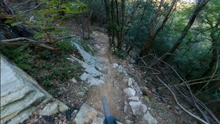
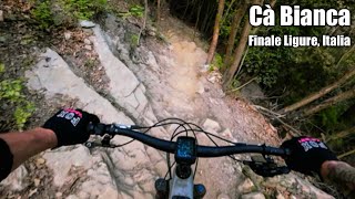
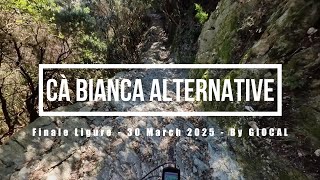
This trail takes its name from the white house (casa bianca in Italian) close to which it starts. Has the first couple of meters in common with Little Champery before that turns right. Cà Bianca keeps going on a straight section before entering a fast section packed with turns banks and steep bits.
It ends on a rocky section close to a river and through some houses in Feglino.

source: ...
Access Info

Feglino is reachable from the E80 highway accessing Orco Feglino, then drive north on the SP27 until Ca' de' Ramundi (Chiesa di San Rocco).

Disclaimer

Given its nature, the trail can change after weather happenings and season changes. Always pay attention.

Trail Supporters
Local Trail Association

Recent Activity on Trail

Past Week
  • 9 rides
  • 24 miles average
6 Months
  • 494 rides
  • 25 miles avg distance
All
  • 1,974 rides
  • Last: Jun 18, 2026
c1c2c3c4
January
February
March
April
May
June
July
August
September
October
November
December
Status:
on Jun 6, 2026
Very Dry
Avg: 4.52 (97 votes)
Your vote: 0

view (12,232)
close
3D
Trail Conditions
  • Unknown
  • Snow Groomed
  • Snow Packed
  • Snow Covered
  • Snow Cover Partial
  • Freeze/thaw Cycle
  • Icy
  • Prevalent Mud
  • Wet
  • Variable
  • Ideal
  • Dry
  • Very Dry
Trail Flow (Ridden Direction)
Trailforks scans users ridelogs to determine the most popular direction each trail is ridden. A good flowing trail network will have most trails flowing in a single direction according to their intension.
The colour categories are based on what percentage of riders are riding a trail in its intended direction.
  • > 96%
  • > 90%
  • > 80%
  • > 70%
  • > 50%
  • < 50%
  • bi-directional trail
  • no data
Trail Last Ridden
Trailforks scans ridelogs to determine the last time a trail was ridden.
  • < 2 days
  • < 1 week
  • < 2 weeks
  • < 1 month
  • < 6 months
  • > 6 months
Trail Ridden Direction
The intended direction a trail should be ridden.
  • Downhill Only
  • Downhill Primary
  • Both Directions
  • Uphill Primary
  • Uphill Only
  • One Direction
Contribute Details
Colors indicate trail is missing specified detail.
  • Description
  • Photos
  • Description & Photos
  • Videos
Trail Popularity ?
Trailforks scans ridelogs to determine which trails are ridden the most in the last 9 months. Trails are compared with nearby trails in the same city region with a possible 25 colour shades. Think of this as a heatmap, more rides = more kinetic energy = warmer colors.
  • most popular
  • popular
  • less popular
  • not popular
ATV/ORV/OHV Filter
Max Vehicle Width
inches
US Cell Coverage
Legend
cell carrier legend

Radar Time
Activity Recordings
Trailforks uses anonymized public activity data. ?
Activity Recordings
Trailforks uses anonymized public activity data. ?
Personal Heatmap
Activity Types
all / none
Options
2
Date range month
Winter Trails
Warning A routing network for winter maps does not exist. Selecting trails using the winter trails layer has been disabled.
Missing Trails
Most Popular
Least Popular
Trails are colored based on popularity. The more popular a trail is, the more red. Less popular trails trend towards green.
Jump Magnitude Heatmap
Heatmap of where riders jump on trails. Zoom in to see individual jumps, click circles to view jump details.
BC Backroad Status

Service Road Atlas is a free to use, community-driven service for viewing and creating reports on the numerous back-country service roads around B.C. and Alberta.

map legend
Slope Aspect
Direction the slope faces
Flat N NE E SE S SW W NW
Trails Deemphasized
Trails are shown in grey.
disable
Only show trails with no bike usage.
Enable
Suggested Layers
Based on selected activity type

    Save the current map location and zoom level as your default home location whenever this page is loaded.

    Save
        Directions to ca-bianca trailhead (44.222690, 8.310350)

        Photos

        22 more »
        415 |
        Dec 31, 2019 @ 12:31pm
        Dec 31, 2019
        320 |
        Mar 22, 2015 @ 3:23am
        Mar 22, 2015
        155 |
        Dec 20, 2022 @ 11:53am
        Dec 20, 2022
        319 |
        Jan 2, 2020 @ 2:03am
        Jan 2, 2020

        Videos

        20 more »
        youtuber Cà Bianca - Finale Ligure | Finale Outdoor Region
        5:49 | 832 | Dec 29, 2023 , Finale Ligure
        youtuber FINALE LIGURE Auch geil: Cà Bianca! ⚫ FULL...
        6:13 | 122 | Mar 27, 2026 , Finale Ligure
        Cà Bianca - Finale Ligure, Italy
        6:12 | 47 | May 20, 2026 , Finale Ligure
        Finale Ligure eMTBing - Trail Cà Bianca...
        8:30 | 219 | Apr 7, 2025 , Finale Ligure

        Trail Lists

        Routes with this trail

        5.0 39 miles 7,253 ft 12 Loop
        Partenza da Loano, risalita da Tovo San Giacomo fino alla Madonna della guardia. Scollinamento zona...
        1.0 16 miles 3,964 ft 8
        giro che raggruppa tra i piu difficile sentieri in zona....h veloce little champery e ca bianca...per...

        15 Reviews & Comments


        We hope you've been enjoying Trailforks!

        Create a FREE account to view trail comments and much more.

        • By cheorchTF Pro & contributors
        • #46085 - 15,236 views

        Frequently Asked Questions About Cà Bianca

        Where is Cà Bianca located?
        Cà Bianca is located in Finale Outdoor Region, Finale Ligure, Italy. It is part of the Finale Outdoor Region trail network. The trailhead is located at coordinates 44.22269, 8.31035.
        How hard is Cà Bianca?
        Cà Bianca is rated as Black difficulty. The physical rating is Moderate. The average grade is 15.5%.
        What is the elevation gain for Cà Bianca?
        Cà Bianca has 2 m of elevation gain. The trail has 218 m of elevation descent. The elevation ranges from 217 m to 434 m.
        Is Cà Bianca a point to point trail?
        Yes, Cà Bianca is a point to point trail. The direction is Downhill Only. The trail type is singletrack.

        Hit the Trail

        Open in App

        Get this trail on your phone instantly.
        open trail in app

        Download Trail

        Save to wishlist, Garmin & download.
        save the trail

        Find Related Routes

        Find routes and users activities that include this trail.
        find routes for this trail

        You must enter a description before submitting.