more stats
2.3 miles
Distance
56 ft
Climb
-805 ft
Descent
00:14:12
Avg time
-749 ft
Altitude change
5,511 ft
Altitude min
6,260 ft
Altitude max
6,260 ft
Altitude start
5,512 ft
Altitude end
-6.1%
Grade
-29.1%
Grade max
11.8%
Grade min
1,184 ft
Distance climb
2 miles
Distance down
860 ft
Distance flat
00:14:12
Avg time

Cairn-Age Details

  • Activities
    • Mountain Bike
    • Hike
    • Trail Running
  • Riding Area
    Pahvant Trail System
    Richfield, Utah
  • Difficulty Rating
  • Voted Difficulty
    Blue (1 vote)
  • Local Popularity
    95 in Mountain Biking [+]
    • 85 in Trail Running
    • 95 in Hiking
  • Global Ranking
    #11235 in Mountain Biking [+]
    • #31 in Trail Running
    • #1413 in Hiking
  • Trail Type
    Singletrack
  • Bike Type
    DH, AM, XC
  • Direction
    Downhill Only
    Popular Direction Shown
  • Physical Rating
    Moderate
  • TTFs on Trail
    Berm, Drop, Jump, Rock Garden
  • Year Opened
    2019

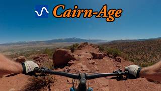
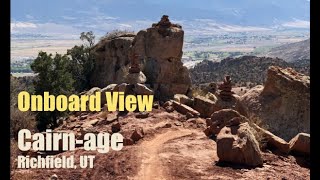
Single track trail that follows through natural and man-made "cairn" rock features. Lots of drops, jumps, rock gardens, and flow sections. This trail is downhill only and is a great intermediate trail.

Access Info

Access trail off of the Kiln-It trail

Local Trail Association

Recent Activity on Trail

Past Week
  • 3 rides
  • 15 miles average
6 Months
  • 104 rides
  • 15 miles avg distance
All
  • 667 rides
  • Last: Jun 20, 2026
c1c2c3c4
January
February
March
April
May
June
July
August
September
October
November
December
update trails status or condition

Cairn-Age Trail Reports

statusdatedescription
May 9, 2026 @ 9:25am (America/Phoenix)
May 9, 2026
Apr 18, 2026 @ 5:15pm (America/Denver)
Apr 18, 2026
Apr 4, 2026 @ 1:35pm (America/Phoenix)
Apr 4, 2026
Dec 14, 2025 @ 1:31pm (America/Denver)
Dec 14, 2025
2 assholes tearing around the trail on motos this afternoon. Ran into them as they were coming uphill quite a ways away from any of the trails...
Dec 13, 2025 @ 1:59pm (America/Phoenix)
Dec 13, 2025
more »
Status:
on May 9, 2026
Ideal
Avg: 4.69 (49 votes)
Your vote: 0

view (4,749)
close
3D
Trail Conditions
  • Unknown
  • Snow Groomed
  • Snow Packed
  • Snow Covered
  • Snow Cover Partial
  • Freeze/thaw Cycle
  • Icy
  • Prevalent Mud
  • Wet
  • Variable
  • Ideal
  • Dry
  • Very Dry
Trail Flow (Ridden Direction)
Trailforks scans users ridelogs to determine the most popular direction each trail is ridden. A good flowing trail network will have most trails flowing in a single direction according to their intension.
The colour categories are based on what percentage of riders are riding a trail in its intended direction.
  • > 96%
  • > 90%
  • > 80%
  • > 70%
  • > 50%
  • < 50%
  • bi-directional trail
  • no data
Trail Last Ridden
Trailforks scans ridelogs to determine the last time a trail was ridden.
  • < 2 days
  • < 1 week
  • < 2 weeks
  • < 1 month
  • < 6 months
  • > 6 months
Trail Ridden Direction
The intended direction a trail should be ridden.
  • Downhill Only
  • Downhill Primary
  • Both Directions
  • Uphill Primary
  • Uphill Only
  • One Direction
Contribute Details
Colors indicate trail is missing specified detail.
  • Description
  • Photos
  • Description & Photos
  • Videos
Trail Popularity ?
Trailforks scans ridelogs to determine which trails are ridden the most in the last 9 months. Trails are compared with nearby trails in the same city region with a possible 25 colour shades. Think of this as a heatmap, more rides = more kinetic energy = warmer colors.
  • most popular
  • popular
  • less popular
  • not popular
ATV/ORV/OHV Filter
Max Vehicle Width
inches
US Cell Coverage
Legend
cell carrier legend

Radar Time
Activity Recordings
Trailforks uses anonymized public activity data. ?
Activity Recordings
Trailforks uses anonymized public activity data. ?
Personal Heatmap
Activity Types
all / none
Options
2
Date range month
Winter Trails
Warning A routing network for winter maps does not exist. Selecting trails using the winter trails layer has been disabled.
Missing Trails
Most Popular
Least Popular
Trails are colored based on popularity. The more popular a trail is, the more red. Less popular trails trend towards green.
Jump Magnitude Heatmap
Heatmap of where riders jump on trails. Zoom in to see individual jumps, click circles to view jump details.
BC Backroad Status

Service Road Atlas is a free to use, community-driven service for viewing and creating reports on the numerous back-country service roads around B.C. and Alberta.

map legend
Slope Aspect
Direction the slope faces
Flat N NE E SE S SW W NW
Trails Deemphasized
Trails are shown in grey.
disable
Only show trails with no bike usage.
Enable
Suggested Layers
Based on selected activity type

    Save the current map location and zoom level as your default home location whenever this page is loaded.

    Save
        Directions to cairnage trailhead (38.785580, -112.115760)

        Photos

        33 more »
        128 |
        Sep 30, 2024 @ 6:35am
        Sep 30, 2024
        137 |
        Sep 30, 2024 @ 6:35am
        Sep 30, 2024
        135 |
        May 11, 2024 @ 12:12pm
        May 11, 2024
        125 |
        May 7, 2024 @ 3:12pm
        May 7, 2024

        Videos

        9 more »
        youtuber Best Intermediate MTB trail in Richfield, UT -...
        12:28 | 93 | May 1, 2026 , Richfield
        Cairn-Age Mountain Bike Trail | Richfield, UT
        7:28 | 744 | Apr 4, 2022 , Richfield
        Telegraph & Snake Bite Trails (One of My...
        33:12 | 237 | Nov 18, 2021 , Richfield
        Richfield, UT   Kiln it to Cairn Age
        4:14 | 433 | Jun 19, 2021 , Richfield

        Routes with this trail

        5.0 15 miles 2,283 ft 23 Loop
        Two loops in order to hit Juniper Drop, and Cairn-age. Hits most of the trails other than Spinal Tap.
        3.0 12 miles 1,676 ft 5
        For the more adventurous take this route to the top to enjoy the full downhill experience. The trail is...
        5.0 29 miles 4,264 ft 16
        Hit all best trails in one epic ride

        19 Reviews & Comments


        We hope you've been enjoying Trailforks!

        Create a FREE account to view trail comments and much more.

        • By cbd23TF Pro RCTC & contributors
        • #195620 - 6,580 views

        Frequently Asked Questions About Cairn-Age

        Where is Cairn-Age located?
        Cairn-Age is located in Pahvant Trail System, Richfield, Utah, United States. It is part of the Pahvant Trail System trail network. The trailhead is located at coordinates 38.78558, -112.11576.
        How hard is Cairn-Age?
        Cairn-Age is rated as Blue difficulty. The physical rating is Moderate. The average grade is 6.1%.
        What is the elevation gain for Cairn-Age?
        Cairn-Age has 56 ft of elevation gain. The trail has 805 ft of elevation descent. The elevation ranges from 5,511 ft to 6,260 ft.
        Is Cairn-Age a point to point trail?
        Yes, Cairn-Age is a point to point trail. The direction is Downhill Only. The trail type is singletrack.

        Hit the Trail

        Open in App

        Get this trail on your phone instantly.
        open trail in app

        Download Trail

        Save to wishlist, Garmin & download.
        save the trail

        Find Related Routes

        Find routes and users activities that include this trail.
        find routes for this trail

        You must enter a description before submitting.