more stats
4,908 ft
Distance
-548 ft
Descent
00:07:52
Avg time
-550 ft
Altitude change
570 ft
Altitude min
1,122 ft
Altitude max
1,120 ft
Altitude start
571 ft
Altitude end
-11.2%
Grade
-37.3%
Grade max
2.8%
Grade min
16 ft
Distance climb
4,544 ft
Distance down
348 ft
Distance flat
00:07:52
Avg time

Cal Dimoni Details

  • Activities
    • Mountain Bike
    • E-Bike
    • Hike
    • Trail Running
  • Riding Area
  • Difficulty Rating
  • Voted Difficulty
    Blue (7 votes)
  • Local Popularity
    95 in Mountain Biking [+]
    • 100 in E-Biking
    • 75 in Trail Running
    • 70 in Hiking
  • Global Ranking
    #27526 in Mountain Biking [+]
    • #819 in E-Biking
    • #36284 in Trail Running
    • #82194 in Hiking
  • Hiking SAC Scale
    T1 Hiking
  • Trail Type
    Singletrack
  • Bike Type
    AM, XC
  • Direction
    Downhill Only
    Popular Direction Shown
  • Physical Rating
    Moderate
  • Trail Visibility
    Always easy to follow
  • Dogs Allowed
    Yes
  • eBike Allowed
    Yes up to Class 1
  • TTFs on Trail
    Berm, Drop, Jump, Rock Garden

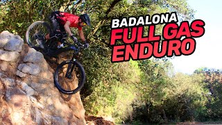
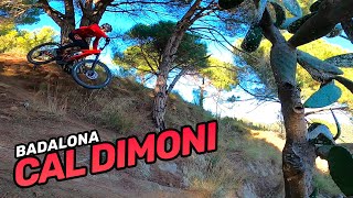
CA: comença amb molt de flow i molt fàcil. A la meitat trobem uns petits esglaons a causa de l'aigua que amb la pròpia velocitat es fan sols i l'hi donen gràcia a la trialera. Passat això es torna fàcil de nou.
EN: Eroded trail with visible roots, rock gardens and unavoidable drops. It contains some jumps that are avoidable

This trail is unsanctioned.

Recent Activity on Trail

Past Week
  • 13 rides
  • 17 miles average
6 Months
  • 238 rides
  • 17 miles avg distance
All
  • 508 rides
  • Last: Jun 17, 2026
c1c2c3c4
January
February
March
April
May
June
July
August
September
October
November
December
update trails status or condition

Cal Dimoni Trail Reports

statusdatedescription
Apr 17, 2026 @ 10:47am (Europe/Andorra)
Apr 17, 2026
Apr 17, 2026 @ 10:47am (Europe/Andorra)
Apr 17, 2026
Apr 15, 2026 @ 7:43pm (Europe/Madrid)
Apr 15, 2026
Le he agregado un poco de tierra y pisadk en la recepción del salto luego de el peralte grande. Nose ha modificado nada del excelente currazo que...
Apr 13, 2026 @ 10:15am (Europe/Madrid)
Apr 13, 2026
En perfectas condiciones. Currazo y mucho flow.
Mar 27, 2026 @ 9:11pm (Europe/Madrid)
Mar 27, 2026
more »
Status:
on Apr 17, 2026
Very Dry
Avg: 4.42 (13 votes)
Your vote: 0

view (5,015)
close
3D
Trail Conditions
  • Unknown
  • Snow Groomed
  • Snow Packed
  • Snow Covered
  • Snow Cover Partial
  • Freeze/thaw Cycle
  • Icy
  • Prevalent Mud
  • Wet
  • Variable
  • Ideal
  • Dry
  • Very Dry
Trail Flow (Ridden Direction)
Trailforks scans users ridelogs to determine the most popular direction each trail is ridden. A good flowing trail network will have most trails flowing in a single direction according to their intension.
The colour categories are based on what percentage of riders are riding a trail in its intended direction.
  • > 96%
  • > 90%
  • > 80%
  • > 70%
  • > 50%
  • < 50%
  • bi-directional trail
  • no data
Trail Last Ridden
Trailforks scans ridelogs to determine the last time a trail was ridden.
  • < 2 days
  • < 1 week
  • < 2 weeks
  • < 1 month
  • < 6 months
  • > 6 months
Trail Ridden Direction
The intended direction a trail should be ridden.
  • Downhill Only
  • Downhill Primary
  • Both Directions
  • Uphill Primary
  • Uphill Only
  • One Direction
Contribute Details
Colors indicate trail is missing specified detail.
  • Description
  • Photos
  • Description & Photos
  • Videos
Trail Popularity ?
Trailforks scans ridelogs to determine which trails are ridden the most in the last 9 months. Trails are compared with nearby trails in the same city region with a possible 25 colour shades. Think of this as a heatmap, more rides = more kinetic energy = warmer colors.
  • most popular
  • popular
  • less popular
  • not popular
ATV/ORV/OHV Filter
Max Vehicle Width
inches
US Cell Coverage
Legend
cell carrier legend

Radar Time
Activity Recordings
Trailforks uses anonymized public activity data. ?
Activity Recordings
Trailforks uses anonymized public activity data. ?
Personal Heatmap
Activity Types
all / none
Options
2
Date range month
Winter Trails
Warning A routing network for winter maps does not exist. Selecting trails using the winter trails layer has been disabled.
Missing Trails
Most Popular
Least Popular
Trails are colored based on popularity. The more popular a trail is, the more red. Less popular trails trend towards green.
Jump Magnitude Heatmap
Heatmap of where riders jump on trails. Zoom in to see individual jumps, click circles to view jump details.
BC Backroad Status

Service Road Atlas is a free to use, community-driven service for viewing and creating reports on the numerous back-country service roads around B.C. and Alberta.

map legend
Slope Aspect
Direction the slope faces
Flat N NE E SE S SW W NW
Trails Deemphasized
Trails are shown in grey.
disable
Only show trails with no bike usage.
Enable
Suggested Layers
Based on selected activity type

    Save the current map location and zoom level as your default home location whenever this page is loaded.

    Save
        Directions to cal-dimoni trailhead (41.487450, 2.227710)

        Photos

        2 more »
        38 |
        Mar 22, 2026 @ 2:21am
        Mar 22, 2026
        39 |
        Mar 22, 2026 @ 2:21am
        Mar 22, 2026
        25 |
        Apr 15, 2026 @ 10:43am
        Apr 15, 2026
        48 |
        Mar 4, 2026 @ 12:16am
        Mar 4, 2026

        Videos

        5 more »
        5+1 Bajadas de Enduro MTB en Badalona |...
        14:46 | 358 | Sep 4, 2022 , Badalona
        BCN Lunch Lap: Cal Dimoni on MTB
        0:01 | 235 | Mar 6, 2022 , Badalona
        RAW clips TRIALERA de CAL DIMONI  | Badalona |...
        0:30 | 290 | Dec 22, 2021 , Badalona
        Cal Dimoni DH (following Joan)
        4:52 | 468 | Mar 27, 2020 , Badalona

        Routes with this trail

        22 miles 4,985 ft 35 Loop
        Ruta Enduro Serralada de Marina

        9 Reviews & Comments


        We hope you've been enjoying Trailforks!

        Create a FREE account to view trail comments and much more.

        • #150205 - 2,569 views

        Frequently Asked Questions About Cal Dimoni

        Where is Cal Dimoni located?
        Cal Dimoni is located in Badalona, Spain. It is part of the Badalona trail network. The trailhead is located at coordinates 41.48745, 2.22771.
        How hard is Cal Dimoni?
        Cal Dimoni is rated as Blue difficulty. The physical rating is Moderate. The average grade is 11.2%.
        What is the elevation gain for Cal Dimoni?
        The trail has 167 m of elevation descent. The elevation ranges from 174 m to 342 m.
        Is Cal Dimoni a point to point trail?
        Yes, Cal Dimoni is a point to point trail. The direction is Downhill Only. The trail type is singletrack.

        Hit the Trail

        Open in App

        Get this trail on your phone instantly.
        open trail in app

        Download Trail

        Save to wishlist, Garmin & download.
        save the trail

        Find Related Routes

        Find routes and users activities that include this trail.
        find routes for this trail

        You must enter a description before submitting.