more stats
3,192 ft
Distance
-414 ft
Descent
00:07:15
Avg time
-414 ft
Altitude change
779 ft
Altitude min
1,193 ft
Altitude max
1,193 ft
Altitude start
778 ft
Altitude end
-13%
Grade
-31%
Grade max
-1.2%
Grade min
3,192 ft
Distance down
00:07:15
Avg time

Calculated Risk Details

  • Activities
    • Mountain Bike
    • E-Bike
  • Riding Area
    Spirit Mountain Bike Park
    Duluth, Minnesota
  • Difficulty Rating
  • Local Popularity
    40 in Mountain Biking [+]
    • 40 in E-Biking
  • Global Ranking
    #82229 in Mountain Biking [+]
    • #93927 in E-Biking
  • Trail Type
    Singletrack
  • Bike Type
    DH
  • Dogs Allowed
    Yes
  • eBike Allowed
    Yes up to Class 1
  • TTFs on Trail
    Berm, Drop, Rock Face, Rock Garden
  • Land Owner

Calculated Risk – Most difficult / Expert
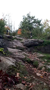
Calculated Risk is a expert level downhill trail with large jumps and lots of rock. This trail features the highest level of difficulty on the hill big high speed jumps and high consequence rock faces give this trail its expert rating. Experienced riders only.

Trail Supporters

Bike Park

Recent Activity on Trail

Past Week
  • 0 rides
  •  
6 Months
  • 0 rides
  •  
All
  • 119 rides
  • Last: May 31, 2026
c1c2c3c4
January
February
March
April
May
June
July
August
September
October
November
December
update trails status or condition

Calculated Risk Trail Reports

Status:
on Jun 19, 2026
Wet
Avg: 4.65 (14 votes)
Your vote: 0

view (1,183)
close
3D
Trail Conditions
  • Unknown
  • Snow Groomed
  • Snow Packed
  • Snow Covered
  • Snow Cover Partial
  • Freeze/thaw Cycle
  • Icy
  • Prevalent Mud
  • Wet
  • Variable
  • Ideal
  • Dry
  • Very Dry
Trail Flow (Ridden Direction)
Trailforks scans users ridelogs to determine the most popular direction each trail is ridden. A good flowing trail network will have most trails flowing in a single direction according to their intension.
The colour categories are based on what percentage of riders are riding a trail in its intended direction.
  • > 96%
  • > 90%
  • > 80%
  • > 70%
  • > 50%
  • < 50%
  • bi-directional trail
  • no data
Trail Last Ridden
Trailforks scans ridelogs to determine the last time a trail was ridden.
  • < 2 days
  • < 1 week
  • < 2 weeks
  • < 1 month
  • < 6 months
  • > 6 months
Trail Ridden Direction
The intended direction a trail should be ridden.
  • Downhill Only
  • Downhill Primary
  • Both Directions
  • Uphill Primary
  • Uphill Only
  • One Direction
Contribute Details
Colors indicate trail is missing specified detail.
  • Description
  • Photos
  • Description & Photos
  • Videos
Trail Popularity ?
Trailforks scans ridelogs to determine which trails are ridden the most in the last 9 months. Trails are compared with nearby trails in the same city region with a possible 25 colour shades. Think of this as a heatmap, more rides = more kinetic energy = warmer colors.
  • most popular
  • popular
  • less popular
  • not popular
ATV/ORV/OHV Filter
Max Vehicle Width
inches
US Cell Coverage
Legend
cell carrier legend

Radar Time
Activity Recordings
Trailforks uses anonymized public activity data. ?
Activity Recordings
Trailforks uses anonymized public activity data. ?
Personal Heatmap
Activity Types
all / none
Options
2
Date range month
Winter Trails
Warning A routing network for winter maps does not exist. Selecting trails using the winter trails layer has been disabled.
Missing Trails
Most Popular
Least Popular
Trails are colored based on popularity. The more popular a trail is, the more red. Less popular trails trend towards green.
Jump Magnitude Heatmap
Heatmap of where riders jump on trails. Zoom in to see individual jumps, click circles to view jump details.
BC Backroad Status

Service Road Atlas is a free to use, community-driven service for viewing and creating reports on the numerous back-country service roads around B.C. and Alberta.

map legend
Slope Aspect
Direction the slope faces
Flat N NE E SE S SW W NW
Trails Deemphasized
Trails are shown in grey.
disable
Only show trails with no bike usage.
Enable
Suggested Layers
Based on selected activity type

    Save the current map location and zoom level as your default home location whenever this page is loaded.

    Save
        Directions to calculated-risk trailhead (46.715720, -92.217900)

        Photos

        92 more »
        232 |
        Aug 8, 2022 @ 8:30am
        Aug 8, 2022
        200 |
        Aug 8, 2022 @ 8:30am
        Aug 8, 2022
        218 |
        Aug 8, 2022 @ 8:30am
        Aug 8, 2022
        189 |
        Aug 23, 2021 @ 4:10pm
        Aug 23, 2021

        Videos

        7 more »
        Calculated Risk @ Spirit Mountain, Duluth
        4:04 | 1251 | Oct 27, 2018 , Duluth
        Friday Fails Submission
        0:08 | 790 | Jan 3, 2020 , Duluth
        The Abominable Shredder
        3:08 | 8763 | Feb 20, 2018 , Duluth
        Charles is going to need a lawyer for that case...
        0:29 | 45100 | Oct 23, 2015 , Duluth

        Trail Products

        3 Reviews & Comments


        We hope you've been enjoying Trailforks!

        Create a FREE account to view trail comments and much more.

        Frequently Asked Questions About Calculated Risk

        Where is Calculated Risk located?
        Calculated Risk is located in Spirit Mountain, Duluth, Minnesota, United States. It is part of the Spirit Mountain trail network. The trailhead is located at coordinates 46.71572, -92.2179.
        How hard is Calculated Risk?
        Calculated Risk is rated as Double Black Diamond difficulty. The average grade is 13%.
        What is the elevation gain for Calculated Risk?
        The trail has 414 ft of elevation descent. The elevation ranges from 779 ft to 1,193 ft.
        How long is Calculated Risk?
        Calculated Risk is 3,192 ft long. The trail type is singletrack.

        Hit the Trail

        Open in App

        Get this trail on your phone instantly.
        open trail in app

        Download Trail

        Save to wishlist, Garmin & download.
        save the trail

        Find Related Routes

        Find routes and users activities that include this trail.
        find routes for this trail

        You must enter a description before submitting.