more stats
4,229 ft
Distance
7 ft
Climb
-695 ft
Descent
00:06:21
Avg time
-688 ft
Altitude change
601 ft
Altitude min
1,292 ft
Altitude max
1,289 ft
Altitude start
600 ft
Altitude end
-16.3%
Grade
-72.2%
Grade max
4.8%
Grade min
187 ft
Distance climb
3,924 ft
Distance down
118 ft
Distance flat
00:06:21
Avg time

Calimero Details

  • Activities
    • Mountain Bike
    • E-Bike
  • Riding Area
    Argentona
    Mataró
  • Difficulty Rating
  • Voted Difficulty
    Blue (2 votes)
  • Local Popularity
    95 in Mountain Biking [+]
    • 100 in E-Biking
  • Global Ranking
    #1193 in Mountain Biking [+]
    • #48 in E-Biking
  • Trail Type
    Singletrack
  • Bike Type
    AM
  • Direction
    Downhill Only
    Popular Direction Shown
  • Trail Visibility
    Always easy to follow
  • Dogs Allowed
    Yes
  • eBike Allowed
    Yes up to Class 1
  • TTFs on Trail
    Berm, Drop

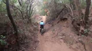
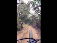
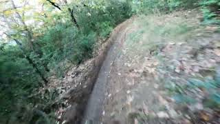
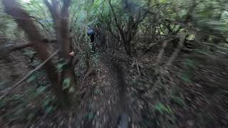
Dels millors corriols de flow de la zona, la part de dalt són tot curves amb força peraltes ràpids. La part de baix és més plana i ressegueix la part d'una petita riera amb alguns arbres que es poden passar bé. Hi ha un gran arbre caigut que s'ha aprofitat per fer un tallat narutal.

Recent Activity on Trail

Past Week
  • 1 rides
  • 45 miles average
6 Months
  • 33 rides
  • 21 miles avg distance
All
  • 160 rides
  • Last: Jun 17, 2026
c1c2c3c4
January
February
March
April
May
June
July
August
September
October
November
December
update trails status or condition

Calimero Trail Reports

statusdatedescription
Jun 10, 2026 @ 6:12pm (Europe/Andorra)
Jun 10, 2026
May 6, 2026 @ 8:54am (Europe/Madrid)
May 5, 2026
Apr 1, 2026 @ 9:07pm (Europe/Madrid)
Apr 1, 2026
reporter Una mica de batxes en algun punt però en general perfecte
Mar 29, 2026 @ 7:23pm (Europe/Madrid)
Mar 29, 2026
Bien en general. Hay una zona donde el agua y las motos han desmontado el camino, han hecho una alternativa pero me la he saltado.
Nov 29, 2025 @ 4:13pm (Europe/Madrid)
Nov 29, 2025
reporter Tot perfecte
more »
Status:
on Jun 10, 2026
Dry
Avg: 4.25 (15 votes)
Your vote: 0

view (3,146)
close
3D
Trail Conditions
  • Unknown
  • Snow Groomed
  • Snow Packed
  • Snow Covered
  • Snow Cover Partial
  • Freeze/thaw Cycle
  • Icy
  • Prevalent Mud
  • Wet
  • Variable
  • Ideal
  • Dry
  • Very Dry
Trail Flow (Ridden Direction)
Trailforks scans users ridelogs to determine the most popular direction each trail is ridden. A good flowing trail network will have most trails flowing in a single direction according to their intension.
The colour categories are based on what percentage of riders are riding a trail in its intended direction.
  • > 96%
  • > 90%
  • > 80%
  • > 70%
  • > 50%
  • < 50%
  • bi-directional trail
  • no data
Trail Last Ridden
Trailforks scans ridelogs to determine the last time a trail was ridden.
  • < 2 days
  • < 1 week
  • < 2 weeks
  • < 1 month
  • < 6 months
  • > 6 months
Trail Ridden Direction
The intended direction a trail should be ridden.
  • Downhill Only
  • Downhill Primary
  • Both Directions
  • Uphill Primary
  • Uphill Only
  • One Direction
Contribute Details
Colors indicate trail is missing specified detail.
  • Description
  • Photos
  • Description & Photos
  • Videos
Trail Popularity ?
Trailforks scans ridelogs to determine which trails are ridden the most in the last 9 months. Trails are compared with nearby trails in the same city region with a possible 25 colour shades. Think of this as a heatmap, more rides = more kinetic energy = warmer colors.
  • most popular
  • popular
  • less popular
  • not popular
ATV/ORV/OHV Filter
Max Vehicle Width
inches
US Cell Coverage
Legend
cell carrier legend

Radar Time
Activity Recordings
Trailforks uses anonymized public activity data. ?
Activity Recordings
Trailforks uses anonymized public activity data. ?
Personal Heatmap
Activity Types
all / none
Options
2
Date range month
Winter Trails
Warning A routing network for winter maps does not exist. Selecting trails using the winter trails layer has been disabled.
Missing Trails
Most Popular
Least Popular
Trails are colored based on popularity. The more popular a trail is, the more red. Less popular trails trend towards green.
Jump Magnitude Heatmap
Heatmap of where riders jump on trails. Zoom in to see individual jumps, click circles to view jump details.
BC Backroad Status

Service Road Atlas is a free to use, community-driven service for viewing and creating reports on the numerous back-country service roads around B.C. and Alberta.

map legend
Slope Aspect
Direction the slope faces
Flat N NE E SE S SW W NW
Trails Deemphasized
Trails are shown in grey.
disable
Only show trails with no bike usage.
Enable
Suggested Layers
Based on selected activity type

    Save the current map location and zoom level as your default home location whenever this page is loaded.

    Save
        Directions to calimero trailhead (41.543310, 2.369600)

        Photos

        0 more »
        53 |
        Jul 21, 2024 @ 4:51am
        Jul 21, 2024
        43 |
        Jul 19, 2024 @ 2:13pm
        Jul 19, 2024
        50 |
        Jul 19, 2024 @ 2:13pm
        Jul 19, 2024

        Videos

        4 more »
        La Calimero mola mucho seguido por @lucaloku
        3:26 | 891 | Oct 7, 2023 , Mataró
        Descens Calimero, Jordi de llebre
        4:18 | 220 | Jun 18, 2023 , Mataró
        Calimero - cabrera movie
        2:09 | 283 | Feb 14, 2023 , Mataró
        E-Calimero con Tati de liebre
        3:38 | 459 | Jan 21, 2021 , Mataró

        5 Reviews & Comments


        We hope you've been enjoying Trailforks!

        Create a FREE account to view trail comments and much more.

        • By snaker4TF Pro TFSPAIN & contributors
        • #390477 - 2,267 views

        Frequently Asked Questions About Calimero

        Where is Calimero located?
        Calimero is located in Argentona, Mataró, Spain. It is part of the Argentona trail network. The trailhead is located at coordinates 41.54331, 2.3696.
        How hard is Calimero?
        Calimero is rated as Blue difficulty. The average grade is 16.3%.
        What is the elevation gain for Calimero?
        Calimero has 2 m of elevation gain. The trail has 212 m of elevation descent. The elevation ranges from 183 m to 394 m.
        Is Calimero a point to point trail?
        Yes, Calimero is a point to point trail. The direction is Downhill Only. The trail type is singletrack.

        Hit the Trail

        Open in App

        Get this trail on your phone instantly.
        open trail in app

        Download Trail

        Save to wishlist, Garmin & download.
        save the trail

        Find Related Routes

        Find routes and users activities that include this trail.
        find routes for this trail

        You must enter a description before submitting.