more stats
2,300 ft
Distance
3 ft
Climb
-260 ft
Descent
00:02:09
Avg time
-258 ft
Altitude change
1,386 ft
Altitude min
1,644 ft
Altitude max
1,644 ft
Altitude start
1,388 ft
Altitude end
-11.2%
Grade
-46.7%
Grade max
3.8%
Grade min
66 ft
Distance climb
1,864 ft
Distance down
236 ft
Distance flat
00:02:09
Avg time

Call Me Chris Details

  • Activities
    • Mountain Bike
    • E-Bike
  • Riding Area
  • Difficulty Rating
  • Local Popularity
    90 in Mountain Biking [+]
    • 80 in E-Biking
  • Global Ranking
    #1032 in Mountain Biking [+]
    • #16135 in E-Biking
  • Trail Type
    Singletrack
  • Bike Type
    AM
  • Direction
    Downhill Only
    Popular Direction Shown
  • Trail Visibility
    Always easy to follow
  • Family Friendly
    Yes
  • Dogs Allowed
    Yes
  • eBike Allowed
    Yes up to Class 1
  • TTFs on Trail
    Berm, Drop, Jump, Rock Garden, Roller Coaster
  • Ride in Rain
    Yes
  • Year Opened
    2023
  • Land Owner
    MacRobert Trust

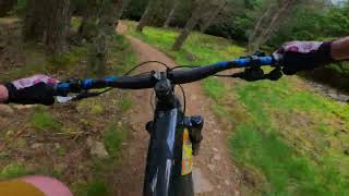
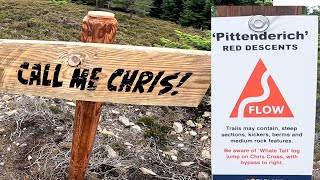
From the cairn at the top of Pittenderich this trail drops into sublime sets of snaking berms, interspersed with a few short rock gardens to keep you on your toes. Named in honour of the many Chris’ involved with Tarland Trails. You will be seeing a lot of ‘Seymour Butts’ as you do ‘just one more run’.

Local Trail Association

Recent Activity on Trail

Past Week
  • 6 rides
  • 13 miles average
6 Months
  • 72 rides
  • 14 miles avg distance
All
  • 669 rides
  • Last: Jun 16, 2026
c1c2c3c4
January
February
March
April
May
June
July
August
September
October
November
December
update trails status or condition

Call Me Chris Trail Reports

Status:
on Jun 16, 2026
Dry
Avg: 4.31 (10 votes)
Your vote: 0

view (7,483)
close
3D
Trail Conditions
  • Unknown
  • Snow Groomed
  • Snow Packed
  • Snow Covered
  • Snow Cover Partial
  • Freeze/thaw Cycle
  • Icy
  • Prevalent Mud
  • Wet
  • Variable
  • Ideal
  • Dry
  • Very Dry
Trail Flow (Ridden Direction)
Trailforks scans users ridelogs to determine the most popular direction each trail is ridden. A good flowing trail network will have most trails flowing in a single direction according to their intension.
The colour categories are based on what percentage of riders are riding a trail in its intended direction.
  • > 96%
  • > 90%
  • > 80%
  • > 70%
  • > 50%
  • < 50%
  • bi-directional trail
  • no data
Trail Last Ridden
Trailforks scans ridelogs to determine the last time a trail was ridden.
  • < 2 days
  • < 1 week
  • < 2 weeks
  • < 1 month
  • < 6 months
  • > 6 months
Trail Ridden Direction
The intended direction a trail should be ridden.
  • Downhill Only
  • Downhill Primary
  • Both Directions
  • Uphill Primary
  • Uphill Only
  • One Direction
Contribute Details
Colors indicate trail is missing specified detail.
  • Description
  • Photos
  • Description & Photos
  • Videos
Trail Popularity ?
Trailforks scans ridelogs to determine which trails are ridden the most in the last 9 months. Trails are compared with nearby trails in the same city region with a possible 25 colour shades. Think of this as a heatmap, more rides = more kinetic energy = warmer colors.
  • most popular
  • popular
  • less popular
  • not popular
ATV/ORV/OHV Filter
Max Vehicle Width
inches
US Cell Coverage
Legend
cell carrier legend

Radar Time
Activity Recordings
Trailforks uses anonymized public activity data. ?
Activity Recordings
Trailforks uses anonymized public activity data. ?
Personal Heatmap
Activity Types
all / none
Options
2
Date range month
Winter Trails
Warning A routing network for winter maps does not exist. Selecting trails using the winter trails layer has been disabled.
Missing Trails
Most Popular
Least Popular
Trails are colored based on popularity. The more popular a trail is, the more red. Less popular trails trend towards green.
Jump Magnitude Heatmap
Heatmap of where riders jump on trails. Zoom in to see individual jumps, click circles to view jump details.
BC Backroad Status

Service Road Atlas is a free to use, community-driven service for viewing and creating reports on the numerous back-country service roads around B.C. and Alberta.

map legend
Slope Aspect
Direction the slope faces
Flat N NE E SE S SW W NW
Trails Deemphasized
Trails are shown in grey.
disable
Only show trails with no bike usage.
Enable
Suggested Layers
Based on selected activity type

    Save the current map location and zoom level as your default home location whenever this page is loaded.

    Save
        Directions to call-me-chris trailhead (57.159300, -2.834860)

        Photos

        36 more »
        55 |
        Apr 11, 2023 @ 3:45pm
        Apr 11, 2023
        68 |
        Nov 23, 2023 @ 2:56pm
        Nov 23, 2023
        30 |
        Jun 27, 2023 @ 2:22am
        Jun 27, 2023
        32 |
        Jun 27, 2023 @ 2:22am
        Jun 27, 2023

        Videos

        6 more »
        Call Me Chris, Tarland Trails 2
        2:00 | 175 | May 27, 2024 , Tarland
        Pittenderich Reds - Tarland Trails 2023 -...
        4:41 | 109 | Oct 6, 2023 , Tarland
        youtuber Call Me Chris - Tarland Trails - Scotland Red...
        2:15 | 134 | Aug 3, 2023 , Tarland
        youtuber How I Overcame My Fear on the Tarland MTB...
        17:52 | 110 | Jun 9, 2023 , Tarland

        Routes with this trail

        15 miles 2,819 ft 32 Out & Back Race
        Race course for the full route of the Tarland Enduro - Round #1 - Tartan Enduro Series 2025 run by...
        17 miles 2,753 ft 28 Loop Race
        Tarland Enduro 2023 - Full Route. Run by DoonThaBrae Events
        15 miles 2,825 ft 35 Out & Back Race
        Tarland Enduro 2024 Run by DoonThaBrae Events

        3 Reviews & Comments


        We hope you've been enjoying Trailforks!

        Create a FREE account to view trail comments and much more.

        • By eastfyfesTF Pro TARLAND ENMBC & contributors
        • #602211 - 1,355 views

        Frequently Asked Questions About Call Me Chris

        Where is Call Me Chris located?
        Call Me Chris is located in Tarland Trails - Pittenderich, Tarland, United Kingdom. It is part of the Tarland Trails - Pittenderich trail network. The trailhead is located at coordinates 57.1593, -2.83486.
        How hard is Call Me Chris?
        Call Me Chris is rated as Red difficulty. The average grade is 11.2%.
        What is the elevation gain for Call Me Chris?
        Call Me Chris has 1 m of elevation gain. The trail has 79 m of elevation descent. The elevation ranges from 423 m to 501 m.
        Is Call Me Chris a point to point trail?
        Yes, Call Me Chris is a point to point trail. The direction is Downhill Only. The trail type is singletrack.

        Hit the Trail

        Open in App

        Get this trail on your phone instantly.
        open trail in app

        Download Trail

        Save to wishlist, Garmin & download.
        save the trail

        Find Related Routes

        Find routes and users activities that include this trail.
        find routes for this trail

        You must enter a description before submitting.