more stats
2.0 miles
Distance
54 ft
Climb
-1,361 ft
Descent
00:21:20
Avg time
-1,311 ft
Altitude change
1,097 ft
Altitude min
2,457 ft
Altitude max
2,408 ft
Altitude start
1,096 ft
Altitude end
-12.6%
Grade
-101.1%
Grade max
13.5%
Grade min
1,591 ft
Distance climb
2 miles
Distance down
390 ft
Distance flat
00:21:20
Avg time

Camaggiore FR Details

  • Activities
    • Mountain Bike
    • Hike
    • Trail Running
  • Riding Area
  • Difficulty Rating
  • Voted Difficulty
    Double Black Diamond (1 vote)
  • Local Popularity
    50 in Mountain Biking [+]
    • 5 in Trail Running
    • 5 in Hiking
  • Global Ranking
    #100584 in Mountain Biking [+]
    • #148972 in Trail Running
    • #144303 in Hiking
  • Hiking SAC Scale
    T2 Mountain Hiking
  • Trail Type
    Singletrack
  • Bike Type
    DH, AM
  • Direction
    Downhill Primary
    Popular Direction Shown
  • Physical Rating
    Hard
  • Trail Visibility
    Always easy to follow
  • Dogs Allowed
    Yes
  • TTFs on Trail
    Drop, Rock Face, Roller Coaster

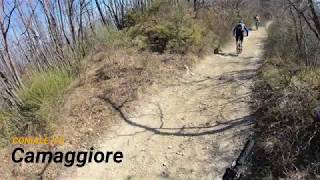
Si parte dalla chiesetta diroccata di S. Cristina. Da qui il sentiero spiana e al bivio tenere la Dx. Un po’ di sali-scendi e poi inizia la discesa di CaMaggiore. Decisamente cattiva e selvaggia all’inizio con una tratto su roccia, impegnativi gradoni e passaggi trialistici, ripidoni su sassi smossi e poi tratti più veloci nel bosco. Ad un bivio (poco evidente e qui il GPS aiuta) tenere la SX. Il sentiero è poco evidente; il primo tratto è largo poi diventa un single track. Dopo un breve tratto in leggera discesa nel bosco si affronta un tratto di salita a spinta (20m) e qui inizia un bel tratto di crinale su roccia (leggermente esposto a DX) con qualche passaggio tecnico, gradoni e passaggi trialistici su roccia e sassi smossi. Poi si entra nel bosco e il single track diventa un veloce tracciato, quasi un toboga con tornantini e curve con sponda naturale

Recent Activity on Trail

Past Week
  • 0 rides
  •  
6 Months
  • 0 rides
  •  
All
  • 3 rides
  • Last: May 10, 2026
c1c2c3c4
January
February
March
April
May
June
July
August
September
October
November
December
update trails status or condition

Camaggiore FR Trail Reports

statusdatedescription
Sep 5, 2021 @ 4:11am
Sep 5, 2021
Everything looks like ok, but on the steep parts lots of big rocks are loose, or in the middle of the path. I guess it's normal here, there were...
Oct 8, 2020 @ 6:12am
Oct 8, 2020
Feb 22, 2020 @ 12:07am
Feb 22, 2020
Jan 11, 2020 @ 12:54am
Jan 11, 2020
Tutto bene, condizioni ottime, andrebbe un minimo sistemata la pietraia, serve manovalanza....
more »
Status:
on Sep 5, 2021
Ideal
Avg: 4.19 (4 votes)
Your vote: 0

view (29)
close
3D
Trail Conditions
  • Unknown
  • Snow Groomed
  • Snow Packed
  • Snow Covered
  • Snow Cover Partial
  • Freeze/thaw Cycle
  • Icy
  • Prevalent Mud
  • Wet
  • Variable
  • Ideal
  • Dry
  • Very Dry
Trail Flow (Ridden Direction)
Trailforks scans users ridelogs to determine the most popular direction each trail is ridden. A good flowing trail network will have most trails flowing in a single direction according to their intension.
The colour categories are based on what percentage of riders are riding a trail in its intended direction.
  • > 96%
  • > 90%
  • > 80%
  • > 70%
  • > 50%
  • < 50%
  • bi-directional trail
  • no data
Trail Last Ridden
Trailforks scans ridelogs to determine the last time a trail was ridden.
  • < 2 days
  • < 1 week
  • < 2 weeks
  • < 1 month
  • < 6 months
  • > 6 months
Trail Ridden Direction
The intended direction a trail should be ridden.
  • Downhill Only
  • Downhill Primary
  • Both Directions
  • Uphill Primary
  • Uphill Only
  • One Direction
Contribute Details
Colors indicate trail is missing specified detail.
  • Description
  • Photos
  • Description & Photos
  • Videos
Trail Popularity ?
Trailforks scans ridelogs to determine which trails are ridden the most in the last 9 months. Trails are compared with nearby trails in the same city region with a possible 25 colour shades. Think of this as a heatmap, more rides = more kinetic energy = warmer colors.
  • most popular
  • popular
  • less popular
  • not popular
ATV/ORV/OHV Filter
Max Vehicle Width
inches
US Cell Coverage
Legend
cell carrier legend

Radar Time
Activity Recordings
Trailforks uses anonymized public activity data. ?
Activity Recordings
Trailforks uses anonymized public activity data. ?
Personal Heatmap
Activity Types
all / none
Options
2
Date range month
Winter Trails
Warning A routing network for winter maps does not exist. Selecting trails using the winter trails layer has been disabled.
Missing Trails
Most Popular
Least Popular
Trails are colored based on popularity. The more popular a trail is, the more red. Less popular trails trend towards green.
Jump Magnitude Heatmap
Heatmap of where riders jump on trails. Zoom in to see individual jumps, click circles to view jump details.
BC Backroad Status

Service Road Atlas is a free to use, community-driven service for viewing and creating reports on the numerous back-country service roads around B.C. and Alberta.

map legend
Slope Aspect
Direction the slope faces
Flat N NE E SE S SW W NW
Trails Deemphasized
Trails are shown in grey.
disable
Only show trails with no bike usage.
Enable
Suggested Layers
Based on selected activity type

    Save the current map location and zoom level as your default home location whenever this page is loaded.

    Save
        Directions to camaggiore-fr trailhead (44.165740, 11.440580)

        Photos

        No photos have been added for Camaggiore FR yet, add a photo.

        Videos

        1 more »
        youtuber Camaggiore, Coniale (FI), 22-02-2020
        6:37 | 676 | Feb 23, 2020 , Imola

        1 Review & Comments


        We hope you've been enjoying Trailforks!

        Create a FREE account to view trail comments and much more.

        • By gpaolocontiTF Pro & contributors
        • #223470 - 831 views

        Frequently Asked Questions About Camaggiore FR

        Where is Camaggiore FR located?
        Camaggiore FR is located in Castel del Rio, Imola, Italy. It is part of the Castel del Rio trail network. The trailhead is located at coordinates 44.16574, 11.44058.
        How hard is Camaggiore FR?
        Camaggiore FR is rated as Black difficulty. The physical rating is Hard. The average grade is 12.6%.
        What is the elevation gain for Camaggiore FR?
        Camaggiore FR has 54 ft of elevation gain. The trail has 1,361 ft of elevation descent. The elevation ranges from 1,097 ft to 2,457 ft.
        Is Camaggiore FR a point to point trail?
        Camaggiore FR is not a point to point trail. The direction is Downhill Primary. The trail type is singletrack.

        Hit the Trail

        Open in App

        Get this trail on your phone instantly.
        open trail in app

        Download Trail

        Save to wishlist, Garmin & download.
        save the trail

        Find Related Routes

        Find routes and users activities that include this trail.
        find routes for this trail

        You must enter a description before submitting.