more stats
1,946 ft
Distance
9 ft
Climb
-135 ft
Descent
00:03:10
Avg time
-127 ft
Altitude change
1,228 ft
Altitude min
1,355 ft
Altitude max
1,355 ft
Altitude start
1,227 ft
Altitude end
-6.5%
Grade
-23.8%
Grade max
4.1%
Grade min
295 ft
Distance climb
1,339 ft
Distance down
308 ft
Distance flat
00:03:10
Avg time

Canada Details

  • Activities
    • Mountain Bike
    • E-Bike
    • Hike
    • Trail Running
  • Riding Area
  • Difficulty Rating
  • Local Popularity
    50 in Mountain Biking [+]
    • 30 in E-Biking
    • 5 in Trail Running
    • 5 in Hiking
  • Global Ranking
    #117161 in Mountain Biking [+]
    • #94808 in E-Biking
    • #164127 in Trail Running
    • #161269 in Hiking
  • Hiking SAC Scale
    T1 Hiking
  • Trail Type
    Singletrack
  • Bike Type
    AM, XC
  • Direction
    Both Directions
    Popular Direction Shown
  • Climb Difficulty
    Blue
  • Physical Rating
    Easy
  • Trail Visibility
    Always easy to follow
  • Dogs Allowed
    Yes
  • eBike Allowed
    Yes up to Class 1

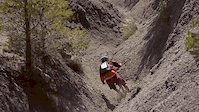
Trail breve ma che si snoda in un secret spot molto suggestivo, la valletta del rio Martello: non sembra di essere a quattro passi da Pecetto E' possibile evitare i primi due tornanti per mezzo di vari tagli piuttosto ripidi ma simpatici.

Access Info

Percorrendo strada Rosero da Pecetto, dopo la regione Albera e prima di arrivare alla frazione Rosero, sulla destra, imbocco poco visibile.

Recent Activity on Trail

Past Week
  • 0 rides
  •  
6 Months
  • 7 rides
  • 19 miles avg distance
All
  • 23 rides
  • Last: Jun 16, 2026
c1c2c3c4
January
February
March
April
May
June
July
August
September
October
November
December
update trails status or condition

Canada Trail Reports

statusdatedescription
Apr 5, 2026 @ 6:25am (Europe/Rome)
Apr 4, 2026
Prime conditions, spectacular on the river session
Apr 9, 2021 @ 11:11pm
Apr 9, 2021
Apr 8, 2021 @ 2:49am
Apr 8, 2021
Nov 29, 2020 @ 12:13am
Nov 29, 2020
May 20, 2020 @ 12:47am
May 20, 2020
Ho percorso il sentiero a piedi la scorsa domenica 17/5/2020. Il primo tratto, che scende fino al Rio Martello, era estremamente fangoso e...
more »
Status:
on Apr 5, 2026
Dry
Avg: 4.13 (1 votes)
Your vote: 0

view (226)
close
3D
Trail Conditions
  • Unknown
  • Snow Groomed
  • Snow Packed
  • Snow Covered
  • Snow Cover Partial
  • Freeze/thaw Cycle
  • Icy
  • Prevalent Mud
  • Wet
  • Variable
  • Ideal
  • Dry
  • Very Dry
Trail Flow (Ridden Direction)
Trailforks scans users ridelogs to determine the most popular direction each trail is ridden. A good flowing trail network will have most trails flowing in a single direction according to their intension.
The colour categories are based on what percentage of riders are riding a trail in its intended direction.
  • > 96%
  • > 90%
  • > 80%
  • > 70%
  • > 50%
  • < 50%
  • bi-directional trail
  • no data
Trail Last Ridden
Trailforks scans ridelogs to determine the last time a trail was ridden.
  • < 2 days
  • < 1 week
  • < 2 weeks
  • < 1 month
  • < 6 months
  • > 6 months
Trail Ridden Direction
The intended direction a trail should be ridden.
  • Downhill Only
  • Downhill Primary
  • Both Directions
  • Uphill Primary
  • Uphill Only
  • One Direction
Contribute Details
Colors indicate trail is missing specified detail.
  • Description
  • Photos
  • Description & Photos
  • Videos
Trail Popularity ?
Trailforks scans ridelogs to determine which trails are ridden the most in the last 9 months. Trails are compared with nearby trails in the same city region with a possible 25 colour shades. Think of this as a heatmap, more rides = more kinetic energy = warmer colors.
  • most popular
  • popular
  • less popular
  • not popular
ATV/ORV/OHV Filter
Max Vehicle Width
inches
US Cell Coverage
Legend
cell carrier legend

Radar Time
Activity Recordings
Trailforks uses anonymized public activity data. ?
Activity Recordings
Trailforks uses anonymized public activity data. ?
Personal Heatmap
Activity Types
all / none
Options
2
Date range month
Winter Trails
Warning A routing network for winter maps does not exist. Selecting trails using the winter trails layer has been disabled.
Missing Trails
Most Popular
Least Popular
Trails are colored based on popularity. The more popular a trail is, the more red. Less popular trails trend towards green.
Jump Magnitude Heatmap
Heatmap of where riders jump on trails. Zoom in to see individual jumps, click circles to view jump details.
BC Backroad Status

Service Road Atlas is a free to use, community-driven service for viewing and creating reports on the numerous back-country service roads around B.C. and Alberta.

map legend
Slope Aspect
Direction the slope faces
Flat N NE E SE S SW W NW
Trails Deemphasized
Trails are shown in grey.
disable
Only show trails with no bike usage.
Enable
Suggested Layers
Based on selected activity type

    Save the current map location and zoom level as your default home location whenever this page is loaded.

    Save
        Directions to canada-288034 trailhead (45.027290, 7.755140)

        Photos

        No photos have been added for Canada yet, add a photo.

        Videos

        4 more »
        Building Maritime Storms. EWS Rd 7 Teaser,...
        0:13 | 7723 | Sep 14, 2016 , Torino
        Teaser BC Bike Trip Project
        0:27 | 408 | Oct 22, 2013 , Torino
        Team North America
        0:00 | 93 | Apr 29, 2017 , Torino
        GoPro of the World clip submission
        0:23 | 628 | Sep 25, 2016 , Torino

        Reviews / Comments

        No reviews yet, be the first to write a review or ask a question.
        Use trail reports to comment on trail conditions.


        We hope you've been enjoying Trailforks!

        Create a FREE account to view trail comments and much more.

        • By solitone & contributors
        • #288034 - 556 views

        Frequently Asked Questions About Canada

        Where is Canada located?
        Canada is located in Colle della Maddalena, Torino, Italy. It is part of the Colle della Maddalena trail network. The trailhead is located at coordinates 45.02729, 7.75514.
        How hard is Canada?
        Canada is rated as Green difficulty. The physical rating is Easy. The average grade is 6.5%. The climb difficulty is rated Blue.
        What is the elevation gain for Canada?
        Canada has 9 ft of elevation gain. The trail has 135 ft of elevation descent. The elevation ranges from 1,228 ft to 1,355 ft.
        Is Canada a point to point trail?
        Canada is not a point to point trail. The direction is Both Directions. The trail type is singletrack.

        Hit the Trail

        Open in App

        Get this trail on your phone instantly.
        open trail in app

        Download Trail

        Save to wishlist, Garmin & download.
        save the trail

        Find Related Routes

        Find routes and users activities that include this trail.
        find routes for this trail

        You must enter a description before submitting.