more stats
1.7 miles
Distance
-979 ft
Descent
00:18:52
Avg time
-979 ft
Altitude change
889 ft
Altitude min
1,868 ft
Altitude max
1,868 ft
Altitude start
889 ft
Altitude end
-10.7%
Grade
-85.6%
Grade max
0.8%
Grade min
2 miles
Distance down
226 ft
Distance flat
00:18:52
Avg time

Canada Details

  • Activities
    • Mountain Bike
    • Hike
    • Trail Running
  • Riding Area
    Dealu' Golului
    Reșița
  • Difficulty Rating
  • Voted Difficulty
    Blue (2 votes)
  • Local Popularity
    95 in Mountain Biking [+]
    • 70 in Trail Running
    • 5 in Hiking
  • Global Ranking
    #40110 in Mountain Biking [+]
    • #131 in Trail Running
    • #125336 in Hiking
  • Trail Type
    Singletrack
  • Bike Type
    AM, XC
  • Direction
    Downhill Only
    Popular Direction Shown
  • Physical Rating
    Moderate
  • Season
    Jan - Dec
  • Dogs Allowed
    Yes
  • TTFs on Trail
    Berm, Drop, Jump, Gap Jump, Rock Garden
  • Ride in Rain
    Yes

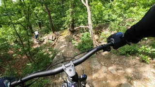
This is generally a fast trail, but has a few technical section, with a lot of rocks. The final rock-garden can be quite tricky. Has a big drop near the beginning and some small jumps. The terrain is rough, with lots of rocks and roots.

Local Trail Association

Recent Activity on Trail

Past Week
  • 0 rides
  •  
6 Months
  • 2 rides
  • 15 miles avg distance
All
  • 47 rides
  • Last: May 30, 2026
c1c2c3c4
January
February
March
April
May
June
July
August
September
October
November
December
update trails status or condition

Canada Trail Reports

statusdatedescription
Oct 19, 2025 @ 10:48am (Europe/Belgrade)
Oct 19, 2025
The big tree branches from the first part were removed, there are still some small fallen trees a bit further on the trail, but you can jump over...
Sep 23, 2025 @ 5:13pm (Europe/Belgrade)
Sep 23, 2025
The trail is well marked with red dots on the trees - this makes it very easy for the riders to descend. Thanks! The trail is mostly covered...
May 1, 2024 @ 12:19am
May 1, 2024
Clean, well maintained
Oct 29, 2023 @ 10:49pm
Oct 29, 2023
a lot of fallen leaves and in the canyon section a bit washed out.
Aug 26, 2023 @ 10:06am
Aug 26, 2023
Lots and lots of fallen trees in the first 10% or so of the trail. Recommend to start after the last time the uphill crosses the trail. The lower...
more »
Status:
on Oct 19, 2025
Variable
Avg: 4.58 (12 votes)
Your vote: 0

view (411)
close
3D
Trail Conditions
  • Unknown
  • Snow Groomed
  • Snow Packed
  • Snow Covered
  • Snow Cover Partial
  • Freeze/thaw Cycle
  • Icy
  • Prevalent Mud
  • Wet
  • Variable
  • Ideal
  • Dry
  • Very Dry
Trail Flow (Ridden Direction)
Trailforks scans users ridelogs to determine the most popular direction each trail is ridden. A good flowing trail network will have most trails flowing in a single direction according to their intension.
The colour categories are based on what percentage of riders are riding a trail in its intended direction.
  • > 96%
  • > 90%
  • > 80%
  • > 70%
  • > 50%
  • < 50%
  • bi-directional trail
  • no data
Trail Last Ridden
Trailforks scans ridelogs to determine the last time a trail was ridden.
  • < 2 days
  • < 1 week
  • < 2 weeks
  • < 1 month
  • < 6 months
  • > 6 months
Trail Ridden Direction
The intended direction a trail should be ridden.
  • Downhill Only
  • Downhill Primary
  • Both Directions
  • Uphill Primary
  • Uphill Only
  • One Direction
Contribute Details
Colors indicate trail is missing specified detail.
  • Description
  • Photos
  • Description & Photos
  • Videos
Trail Popularity ?
Trailforks scans ridelogs to determine which trails are ridden the most in the last 9 months. Trails are compared with nearby trails in the same city region with a possible 25 colour shades. Think of this as a heatmap, more rides = more kinetic energy = warmer colors.
  • most popular
  • popular
  • less popular
  • not popular
ATV/ORV/OHV Filter
Max Vehicle Width
inches
US Cell Coverage
Legend
cell carrier legend

Radar Time
Activity Recordings
Trailforks uses anonymized public activity data. ?
Activity Recordings
Trailforks uses anonymized public activity data. ?
Personal Heatmap
Activity Types
all / none
Options
2
Date range month
Winter Trails
Warning A routing network for winter maps does not exist. Selecting trails using the winter trails layer has been disabled.
Missing Trails
Most Popular
Least Popular
Trails are colored based on popularity. The more popular a trail is, the more red. Less popular trails trend towards green.
Jump Magnitude Heatmap
Heatmap of where riders jump on trails. Zoom in to see individual jumps, click circles to view jump details.
BC Backroad Status

Service Road Atlas is a free to use, community-driven service for viewing and creating reports on the numerous back-country service roads around B.C. and Alberta.

map legend
Slope Aspect
Direction the slope faces
Flat N NE E SE S SW W NW
Trails Deemphasized
Trails are shown in grey.
disable
Only show trails with no bike usage.
Enable
Suggested Layers
Based on selected activity type

    Save the current map location and zoom level as your default home location whenever this page is loaded.

    Save
        Directions to canada-94728 trailhead (45.275830, 21.915550)

        Photos

        4 more »
        115 |
        Mar 1, 2021 @ 10:00am
        Mar 1, 2021
        201 |
        Mar 6, 2018 @ 6:30pm
        Mar 6, 2018
        217 |
        Mar 6, 2018 @ 6:28pm
        Mar 6, 2018
        162 |
        Dec 12, 2019 @ 3:42am
        Dec 12, 2019

        Videos

        2 more »
        MTB Reșița Canada trail cu Robi 2024
        10:42 | 200 | May 1, 2024 , Reșița
        MTB All riders Metal Enduro PS 4 Canada Canion...
        23:30 | 544 | Oct 14, 2019 , Reșița

        Routes with this trail

        5.0 23 miles 4,458 ft 7 Point to Point Race
        More details soon
        5.0 25 miles 5,131 ft 10 Point to Point Race
        Spread out over two opposing hills above the post-industrial city of Resita, the 2021 edition of Metal...
        19 miles 3,935 ft 8 Point to Point Race
        More details soon

        Reviews / Comments

        No reviews yet, be the first to write a review or ask a question.
        Use trail reports to comment on trail conditions.


        We hope you've been enjoying Trailforks!

        Create a FREE account to view trail comments and much more.

        • By pufalotTF Pro TRAILFORKS & contributors
        • #94728 - 1,838 views

        Frequently Asked Questions About Canada

        Where is Canada located?
        Canada is located in Dealu' Golului, Reșița, Romania. It is part of the Dealu' Golului trail network. The trailhead is located at coordinates 45.27583, 21.91555.
        How hard is Canada?
        Canada is rated as Red difficulty. The physical rating is Moderate. The average grade is 10.7%.
        What is the elevation gain for Canada?
        The trail has 979 ft of elevation descent. The elevation ranges from 889 ft to 1,868 ft.
        Is Canada a point to point trail?
        Yes, Canada is a point to point trail. The direction is Downhill Only. The trail type is singletrack.

        Hit the Trail

        Open in App

        Get this trail on your phone instantly.
        open trail in app

        Download Trail

        Save to wishlist, Garmin & download.
        save the trail

        Find Related Routes

        Find routes and users activities that include this trail.
        find routes for this trail

        You must enter a description before submitting.