more stats
3.4 miles
Distance
6 ft
Climb
-1,893 ft
Descent
00:12:46
Avg time
-1,887 ft
Altitude change
4,203 ft
Altitude min
6,090 ft
Altitude max
6,090 ft
Altitude start
4,203 ft
Altitude end
-10.5%
Grade
-40.9%
Grade max
7.3%
Grade min
433 ft
Distance climb
3 miles
Distance down
633 ft
Distance flat
00:12:46
Avg time

Canada Line Details

  • Activities
    • Mountain Bike
  • Riding Area
    Sun Peaks Bike Park
    Sun Peaks, British Columbia
  • Difficulty Rating
  • Local Popularity
    100 in Mountain Biking
  • Global Ranking
    #24280 in Mountain Biking
  • Trail Type
    Machine Groomed
  • Bike Type
    DH, AM
  • Direction
    Downhill Only
    Popular Direction Shown
  • Physical Rating
    Moderate
  • Trail Visibility
    Always easy to follow
  • TTFs on Trail
    Berm, Bridge, Drop, Jump, Rock Face, Wallride
  • Year Opened
    2019

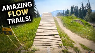
New for 2019. Our signature intermediate jump trail is jam packed with berms, tables, rock jibs and other features sculpted to perfection. Ride arounds for the harder sections and roll-able features mean this trail is the perfect place for newer riders to gain confidence and practice their skills after mastering the green trails.

Trail Supporters

Bike Park

Traditionally Indigenous Territory

Recent Activity on Trail

Past Week
  • 16 rides
  • 18 miles average
6 Months
  • 16 rides
  • 18 miles avg distance
All
  • 1,002 rides
  • Last: Jun 19, 2026
c1c2c3c4
January
February
March
April
May
June
July
August
September
October
November
December
update trails status or condition

Canada Line Trail Reports

statusdatedescription
Jun 13, 2026 @ 12:06pm (America/Vancouver)
Jun 13, 2026
Great shape overall till the last ~1/4 due to some grabby mud spots - veered off to do Resurrection instead.
Oct 4, 2025 @ 8:14am (America/Vancouver)
Oct 4, 2025
The bike park is now closed for the season, see you all in 2026! :D \m/
Sep 1, 2025 @ 11:30am
Sep 1, 2025
Jul 8, 2025 @ 11:31am
Jul 8, 2025
Jul 7, 2025 @ 12:07pm
Jul 7, 2025
more »
Status:
on Jun 13, 2026
Variable
Avg: 4.19 (37 votes)
Your vote: 0

view (9,499)
close
3D
Trail Conditions
  • Unknown
  • Snow Groomed
  • Snow Packed
  • Snow Covered
  • Snow Cover Partial
  • Freeze/thaw Cycle
  • Icy
  • Prevalent Mud
  • Wet
  • Variable
  • Ideal
  • Dry
  • Very Dry
Trail Flow (Ridden Direction)
Trailforks scans users ridelogs to determine the most popular direction each trail is ridden. A good flowing trail network will have most trails flowing in a single direction according to their intension.
The colour categories are based on what percentage of riders are riding a trail in its intended direction.
  • > 96%
  • > 90%
  • > 80%
  • > 70%
  • > 50%
  • < 50%
  • bi-directional trail
  • no data
Trail Last Ridden
Trailforks scans ridelogs to determine the last time a trail was ridden.
  • < 2 days
  • < 1 week
  • < 2 weeks
  • < 1 month
  • < 6 months
  • > 6 months
Trail Ridden Direction
The intended direction a trail should be ridden.
  • Downhill Only
  • Downhill Primary
  • Both Directions
  • Uphill Primary
  • Uphill Only
  • One Direction
Contribute Details
Colors indicate trail is missing specified detail.
  • Description
  • Photos
  • Description & Photos
  • Videos
Trail Popularity ?
Trailforks scans ridelogs to determine which trails are ridden the most in the last 9 months. Trails are compared with nearby trails in the same city region with a possible 25 colour shades. Think of this as a heatmap, more rides = more kinetic energy = warmer colors.
  • most popular
  • popular
  • less popular
  • not popular
ATV/ORV/OHV Filter
Max Vehicle Width
inches
US Cell Coverage
Legend
cell carrier legend

Radar Time
Activity Recordings
Trailforks uses anonymized public activity data. ?
Activity Recordings
Trailforks uses anonymized public activity data. ?
Personal Heatmap
Activity Types
all / none
Options
2
Date range month
Winter Trails
Warning A routing network for winter maps does not exist. Selecting trails using the winter trails layer has been disabled.
Missing Trails
Most Popular
Least Popular
Trails are colored based on popularity. The more popular a trail is, the more red. Less popular trails trend towards green.
Jump Magnitude Heatmap
Heatmap of where riders jump on trails. Zoom in to see individual jumps, click circles to view jump details.
BC Backroad Status

Service Road Atlas is a free to use, community-driven service for viewing and creating reports on the numerous back-country service roads around B.C. and Alberta.

map legend
Slope Aspect
Direction the slope faces
Flat N NE E SE S SW W NW
Trails Deemphasized
Trails are shown in grey.
disable
Only show trails with no bike usage.
Enable
Suggested Layers
Based on selected activity type

    Save the current map location and zoom level as your default home location whenever this page is loaded.

    Save
        Directions to canada-line trailhead (50.900360, -119.909480)

        Photos

        16 more »
        36 |
        Nov 24, 2025 @ 8:21pm
        Nov 24, 2025
        135 |
        Aug 21, 2021 @ 5:56pm
        Aug 21, 2021
        257 |
        Jun 17, 2021 @ 9:33am
        Jun 17, 2021
        234 |
        Jun 17, 2021 @ 9:21am
        Jun 17, 2021

        Videos

        15 more »
        youtuber Riding Fresh New FLOW TRAILS at Sunpeaks Bike...
        14:21 | 670 | Aug 10, 2021 , Sun Peaks
        youtuber This Place Can Really PUSH YOUR LIMITS! -...
        24:41 | 980 | Nov 21, 2019 , Sun Peaks
        youtuber CANADA LINE | Blue trail | SUN PEAKS Bike Park
        11:11 | 149 | Sep 11, 2024 , Sun Peaks
        youtuber Canada Line - Sun Peaks Bike Park
        11:43 | 449 | Aug 11, 2022 , Sun Peaks

        4 Reviews & Comments


        We hope you've been enjoying Trailforks!

        Create a FREE account to view trail comments and much more.

        • By rockystumpyTF Pro & contributors
        • #214518 - 4,329 views

        Frequently Asked Questions About Canada Line

        Where is Canada Line located?
        Canada Line is located in Sun Peaks Bike Park, Sun Peaks, British Columbia, Canada. It is part of the Sun Peaks Bike Park trail network. The trailhead is located at coordinates 50.90036, -119.90948.
        How hard is Canada Line?
        Canada Line is rated as Blue difficulty. The physical rating is Moderate. The average grade is 10.5%.
        What is the elevation gain for Canada Line?
        Canada Line has 2 m of elevation gain. The trail has 577 m of elevation descent. The elevation ranges from 1,281 m to 1,856 m.
        Is Canada Line a point to point trail?
        Yes, Canada Line is a point to point trail. The direction is Downhill Only. The trail type is machine groomed.

        Hit the Trail

        Open in App

        Get this trail on your phone instantly.
        open trail in app

        Download Trail

        Save to wishlist, Garmin & download.
        save the trail

        Find Related Routes

        Find routes and users activities that include this trail.
        find routes for this trail

        You must enter a description before submitting.