more stats
4,383 ft
Distance
-407 ft
Descent
00:04:04
Avg time
-408 ft
Altitude change
799 ft
Altitude min
1,207 ft
Altitude max
1,207 ft
Altitude start
797 ft
Altitude end
-9.3%
Grade
-29.1%
Grade max
-1.6%
Grade min
4,281 ft
Distance down
69 ft
Distance flat
00:04:04
Avg time

Candyland Details

  • Activities
    • Mountain Bike
    • E-Bike
  • Riding Area
    Spirit Mountain Bike Park
    Duluth, Minnesota
  • Difficulty Rating
  • Local Popularity
    60 in Mountain Biking [+]
    • 60 in E-Biking
  • Global Ranking
    #89284 in Mountain Biking [+]
    • #63110 in E-Biking
  • Trail Type
    Singletrack
  • Bike Type
    DH, AM, XC
  • Dogs Allowed
    Yes
  • eBike Allowed
  • TTFs on Trail
    Jump
  • Land Owner

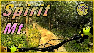
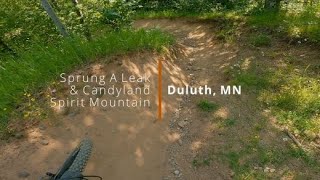
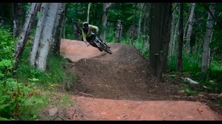
Machine built flow trail that bridges the gap between beginner gravity rider and intermediate. Candyland features more defined rollers and jumps and the berms get a little bit tighter. It is the perfect trail to progress your riding Beginners who have mastered Happy Camper will find this trail a bit more challenging while more advanced riders will find many opportunities to catch a little air. A true crowd pleaser, Candyland was named a model flow trail by the International Mountain Bike Association in 2013.

Trail Supporters

Bike Park

Recent Activity on Trail

Past Week
  • 1 rides
  • 26 miles average
6 Months
  • 14 rides
  • 23 miles avg distance
All
  • 367 rides
  • Last: Jul 2, 2026
c1c2c3c4
January
February
March
April
May
June
July
August
September
October
November
December
update trails status or condition

Candyland Trail Reports

statusdatedescription
Jul 2, 2026 @ 12:49pm (America/Chicago)
1 day
reporter Open to Old Skyline - trail rebuild below Old Skyline
Jul 2, 2026 @ 8:35am (America/Chicago)
1 day
reporter Open
Jun 29, 2026 @ 9:07am (America/Chicago)
Jun 29, 2026
reporter Closed due to rain
Jun 26, 2026 @ 9:26am (America/Chicago)
Jun 26, 2026
reporter Open to Old Skyline - trail rebuild below Old Skyline
Jun 25, 2026 @ 1:04pm (America/Chicago)
Jun 25, 2026
reporter Open
more »
Status:
on Jul 2, 2026
Ideal
Avg: 3.72 (19 votes)
Your vote: 0

view (3,445)
close
3D
Trail Conditions
  • Unknown
  • Snow Groomed
  • Snow Packed
  • Snow Covered
  • Snow Cover Partial
  • Freeze/thaw Cycle
  • Icy
  • Prevalent Mud
  • Wet
  • Variable
  • Ideal
  • Dry
  • Very Dry
Trail Flow (Ridden Direction)
Trailforks scans users ridelogs to determine the most popular direction each trail is ridden. A good flowing trail network will have most trails flowing in a single direction according to their intension.
The colour categories are based on what percentage of riders are riding a trail in its intended direction.
  • > 96%
  • > 90%
  • > 80%
  • > 70%
  • > 50%
  • < 50%
  • bi-directional trail
  • no data
Trail Last Ridden
Trailforks scans ridelogs to determine the last time a trail was ridden.
  • < 2 days
  • < 1 week
  • < 2 weeks
  • < 1 month
  • < 6 months
  • > 6 months
Trail Ridden Direction
The intended direction a trail should be ridden.
  • Downhill Only
  • Downhill Primary
  • Both Directions
  • Uphill Primary
  • Uphill Only
  • One Direction
Contribute Details
Colors indicate trail is missing specified detail.
  • Description
  • Photos
  • Description & Photos
  • Videos
Trail Popularity ?
Trailforks scans ridelogs to determine which trails are ridden the most in the last 9 months. Trails are compared with nearby trails in the same city region with a possible 25 colour shades. Think of this as a heatmap, more rides = more kinetic energy = warmer colors.
  • most popular
  • popular
  • less popular
  • not popular
ATV/ORV/OHV Filter
Max Vehicle Width
inches
US Cell Coverage
Legend
cell carrier legend

Radar Time
Activity Recordings
Trailforks uses anonymized public activity data. ?
Activity Recordings
Trailforks uses anonymized public activity data. ?
Personal Heatmap
Activity Types
all / none
Options
2
Date range month
Winter Trails
Warning A routing network for winter maps does not exist. Selecting trails using the winter trails layer has been disabled.
Missing Trails
Most Popular
Least Popular
Trails are colored based on popularity. The more popular a trail is, the more red. Less popular trails trend towards green.
Jump Magnitude Heatmap
Heatmap of where riders jump on trails. Zoom in to see individual jumps, click circles to view jump details.
BC Backroad Status

Service Road Atlas is a free to use, community-driven service for viewing and creating reports on the numerous back-country service roads around B.C. and Alberta.

map legend
Slope Aspect
Direction the slope faces
Flat N NE E SE S SW W NW
Trails Deemphasized
Trails are shown in grey.
disable
Only show trails with no bike usage.
Enable
Suggested Layers
Based on selected activity type

    Save the current map location and zoom level as your default home location whenever this page is loaded.

    Save
        Directions to candyland trailhead (46.714960, -92.219310)

        Photos

        9 more »
        464 |
        Jul 28, 2013 @ 11:30am
        Jul 28, 2013
        1,359 |
        Jul 28, 2013 @ 11:30am
        Jul 28, 2013
        1,227 |
        Jul 28, 2013 @ 11:30am
        Jul 28, 2013
        267 |
        Nov 23, 2013 @ 8:41am
        Nov 23, 2013

        Videos

        8 more »
        youtuber Mountain Biking Spirit Mountain Duluth MN
        14:09 | 433 | Nov 3, 2022 , Duluth
        Sprung A Leak & Candyland | Spirit...
        5:55 | 344 | Jul 22, 2021 , Duluth
        CandyLand Spirit Mountain Duluth MN [A Green...
        5:18 | 895 | Sep 3, 2018 , Duluth
        2015:Bell-Built Spirit Mountain
        922 | May 27, 2015 , Duluth

        Routes with this trail

        9 miles 1,475 ft 11
        Spirit enduro #1 of the Duluth Enduro Series
        9 miles 1,475 ft 11
        Duluth Enduro Series Spirit #1
        69 miles 5,342 ft 106
        Epic Duluth ride......................

        Trail Products

        Reviews / Comments

        No reviews yet, be the first to write a review or ask a question.
        Use trail reports to comment on trail conditions.


        We hope you've been enjoying Trailforks!

        Create a FREE account to view trail comments and much more.

        Frequently Asked Questions About Candyland

        Where is Candyland located?
        Candyland is located in Spirit Mountain Bike Park, Duluth, Minnesota, United States. It is part of the Spirit Mountain Bike Park trail network. The trailhead is located at coordinates 46.71496, -92.21931.
        How hard is Candyland?
        Candyland is rated as Green difficulty. The average grade is 9.3%.
        What is the elevation gain for Candyland?
        The trail has 407 ft of elevation descent. The elevation ranges from 799 ft to 1,207 ft.
        How long is Candyland?
        Candyland is 4,383 ft long. The trail type is singletrack.

        Hit the Trail

        Open in App

        Get this trail on your phone instantly.
        open trail in app

        Download Trail

        Save to wishlist, Garmin & download.
        save the trail

        Find Related Routes

        Find routes and users activities that include this trail.
        find routes for this trail

        You must enter a description before submitting.