more stats
2.1 miles
Distance
-1,826 ft
Descent
00:12:01
Avg time
-1,826 ft
Altitude change
4,506 ft
Altitude min
6,332 ft
Altitude max
6,332 ft
Altitude start
4,505 ft
Altitude end
-16.5%
Grade
-66.2%
Grade max
-1.9%
Grade min
23 ft
Distance climb
2 miles
Distance down
00:12:01
Avg time

Cannonball Details

  • Activities
    • Mountain Bike
    • E-Bike
  • Riding Area
  • Difficulty Rating
  • Voted Difficulty
    Black Diamond (9 votes)
  • Local Popularity
    75 in Mountain Biking [+]
    • 65 in E-Biking
  • Global Ranking
    #1662 in Mountain Biking [+]
    • #1339 in E-Biking
  • Trail Type
    Singletrack
  • Bike Type
    DH
  • Direction
    Downhill Only
  • Physical Rating
    Hard
  • Trail Visibility
    Always easy to follow
  • Season
    Summer
  • eBike Allowed
    Yes up to Class 1
  • TTFs on Trail
    Berm, Drop, Jump, Gap Jump, Rock Garden, Wallride

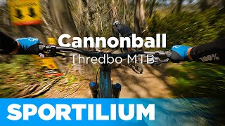
Thredbo’s signature trail, the famous Cannonball DH Trail takes riders to their physical and mental limits. Starting at the top of the Kosciuszko Express Chairlift and descending 600m vertically through the tree-lined Supertrail slopes. Cannonball tests riders with off-camber roots, rock drops, jumps, wall-ride and other technical features that the gravity specialists dream about. Recent upgrades include the addition of World Cup style sections that have been widened with more fall-line added along with some big jumps in the mix for the freeriders *Full-face helmet compulsory.

Bike Park

Traditionally Indigenous Territory

Recent Activity on Trail

Past Week
  • 0 rides
  •  
6 Months
  • 76 rides
  • 38.6 km avg distance
All
  • 357 rides
  • Last: Jan 16, 2026
c1c2c3c4
January
February
March
April
May
June
July
August
September
October
November
December
update trails status or condition

Cannonball Trail Reports

Status:
on Jun 9, 2026
Avg: 4.61 (20 votes)
Your vote: 0

view (10,608)
close
3D
Trail Conditions
  • Unknown
  • Snow Groomed
  • Snow Packed
  • Snow Covered
  • Snow Cover Partial
  • Freeze/thaw Cycle
  • Icy
  • Prevalent Mud
  • Wet
  • Variable
  • Ideal
  • Dry
  • Very Dry
Trail Flow (Ridden Direction)
Trailforks scans users ridelogs to determine the most popular direction each trail is ridden. A good flowing trail network will have most trails flowing in a single direction according to their intension.
The colour categories are based on what percentage of riders are riding a trail in its intended direction.
  • > 96%
  • > 90%
  • > 80%
  • > 70%
  • > 50%
  • < 50%
  • bi-directional trail
  • no data
Trail Last Ridden
Trailforks scans ridelogs to determine the last time a trail was ridden.
  • < 2 days
  • < 1 week
  • < 2 weeks
  • < 1 month
  • < 6 months
  • > 6 months
Trail Ridden Direction
The intended direction a trail should be ridden.
  • Downhill Only
  • Downhill Primary
  • Both Directions
  • Uphill Primary
  • Uphill Only
  • One Direction
Contribute Details
Colors indicate trail is missing specified detail.
  • Description
  • Photos
  • Description & Photos
  • Videos
Trail Popularity ?
Trailforks scans ridelogs to determine which trails are ridden the most in the last 9 months. Trails are compared with nearby trails in the same city region with a possible 25 colour shades. Think of this as a heatmap, more rides = more kinetic energy = warmer colors.
  • most popular
  • popular
  • less popular
  • not popular
ATV/ORV/OHV Filter
Max Vehicle Width
inches
US Cell Coverage
Legend
cell carrier legend

Radar Time
Activity Recordings
Trailforks uses anonymized public activity data. ?
Activity Recordings
Trailforks uses anonymized public activity data. ?
Personal Heatmap
Activity Types
all / none
Options
2
Date range month
Winter Trails
Warning A routing network for winter maps does not exist. Selecting trails using the winter trails layer has been disabled.
Missing Trails
Most Popular
Least Popular
Trails are colored based on popularity. The more popular a trail is, the more red. Less popular trails trend towards green.
Jump Magnitude Heatmap
Heatmap of where riders jump on trails. Zoom in to see individual jumps, click circles to view jump details.
BC Backroad Status

Service Road Atlas is a free to use, community-driven service for viewing and creating reports on the numerous back-country service roads around B.C. and Alberta.

map legend
Slope Aspect
Direction the slope faces
Flat N NE E SE S SW W NW
Trails Deemphasized
Trails are shown in grey.
disable
Only show trails with no bike usage.
Enable
Suggested Layers
Based on selected activity type

    Save the current map location and zoom level as your default home location whenever this page is loaded.

    Save
        Directions to cannonball trailhead (-36.493960, 148.287650)

        Photos

        453 more »
        14 |
        May 17, 2026 @ 10:45pm
        May 17, 2026
        17 |
        May 17, 2026 @ 10:45pm
        May 17, 2026
        19 |
        May 17, 2026 @ 10:45pm
        May 17, 2026
        17 |
        May 17, 2026 @ 10:45pm
        May 17, 2026

        Videos

        56 more »
        youtuber Cannonball  \\  Thredbo MTB
        9:38 | 670 | Jan 25, 2023 , Thredbo
        youtuber We attempted THREDBO'S HARDEST trail |...
        9:47 | 109 | Mar 25, 2024 , Thredbo
        youtuber Most INSANE Moments of 2023! (Pt. 3) - 'The Meat'
        22:04 | 101 | Dec 24, 2023 , Thredbo
        youtuber Best and Worst of 2022! (Part 1)
        18:39 | 156 | Feb 19, 2023 , Thredbo

        3 Reviews & Comments


        We hope you've been enjoying Trailforks!

        Create a FREE account to view trail comments and much more.

        • By TomWalpole & contributors
        • #25483 - 9,516 views

        Frequently Asked Questions About Cannonball

        Where is Cannonball located?
        Cannonball is located in Thredbo Bike Park, Thredbo, Australia. It is part of the Thredbo Bike Park trail network. The trailhead is located at coordinates -36.49396, 148.28765.
        How hard is Cannonball?
        Cannonball is rated as Black Diamond difficulty. The physical rating is Hard. The average grade is 16.5%.
        What is the elevation gain for Cannonball?
        The trail has 1,826 ft of elevation descent. The elevation ranges from 4,506 ft to 6,332 ft.
        Is Cannonball a point to point trail?
        Yes, Cannonball is a point to point trail. The direction is Downhill Only. The trail type is singletrack.

        Hit the Trail

        Open in App

        Get this trail on your phone instantly.
        open trail in app

        Download Trail

        Save to wishlist, Garmin & download.
        save the trail

        Find Related Routes

        Find routes and users activities that include this trail.
        find routes for this trail

        You must enter a description before submitting.