This trail is permanently closed/decommissioned
more stats
1.1 miles
Distance
-1,031 ft
Descent
00:19:00
Avg time
-1,034 ft
Altitude change
7,255 ft
Altitude min
8,289 ft
Altitude max
8,289 ft
Altitude start
7,254 ft
Altitude end
-17.1%
Grade
-71.4%
Grade max
0.5%
Grade min
1 mile
Distance down
121 ft
Distance flat
00:19:00
Avg time

Canyons Downhill Details

  • Activities
    • Mountain Bike
  • Riding Area
    Park City
    , Utah
  • Difficulty Rating
  • Local Popularity
    15 in Mountain Biking
  • Trail Type
    Singletrack
  • Bike Type
    DH, AM
  • Direction
    Downhill Only
    Popular Direction Shown
  • Climb Difficulty
    Green
  • Physical Rating
    Hard
  • Dogs Allowed
    Yes
  • TTFs on Trail
    Rock Face

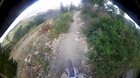
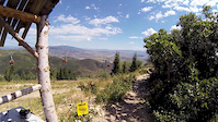
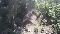
Canyons Downhill is a technical, hand built downhill track starting at look out peak finishing on the front face of Canyons resort. This trail offers a mix of traditional DH elements including rock drops, off camber sections, root sections and rock gardens.

Access Info

Access via short cut lift with a canyons bike park lift ticket.

This trail is unsanctioned.

Traditionally Indigenous Territory

Recent Activity on Trail

Past Week
  • 0 rides
  •  
6 Months
  • 0 rides
  •  
All
  • 26 rides
  • Last: May 24, 2026
c1c2c3c4
January
February
March
April
May
June
July
August
September
October
November
December
update trails status or condition

Canyons Downhill Trail Reports

statusdatedescription
Sep 1, 2025 @ 12:41pm
Sep 1, 2025
Dry with loose rocks. Some over growth, but not bad.
Jun 24, 2024 @ 8:22pm
Jun 24, 2024
Some parts are a bit overgrown, but its all rideable right now!
Aug 21, 2023 @ 10:23am
Aug 21, 2023
Woods section is not rideable due to erosion. Top section is clear
Aug 6, 2022 @ 10:35am
Aug 6, 2022
Last rainstorm did some damage as a drainage rut washed debris onto the trail in the first few switchbacks. Needs more riders.
Jul 17, 2022 @ 8:11pm
Jul 17, 2022
Running well right now. Only overgrown in a few spots.
more »
Status:
on Sep 1, 2025
Dry
Avg: 4.05 (12 votes)
Your vote: 0

view (280)
close
3D
Trail Conditions
  • Unknown
  • Snow Groomed
  • Snow Packed
  • Snow Covered
  • Snow Cover Partial
  • Freeze/thaw Cycle
  • Icy
  • Prevalent Mud
  • Wet
  • Variable
  • Ideal
  • Dry
  • Very Dry
Trail Flow (Ridden Direction)
Trailforks scans users ridelogs to determine the most popular direction each trail is ridden. A good flowing trail network will have most trails flowing in a single direction according to their intension.
The colour categories are based on what percentage of riders are riding a trail in its intended direction.
  • > 96%
  • > 90%
  • > 80%
  • > 70%
  • > 50%
  • < 50%
  • bi-directional trail
  • no data
Trail Last Ridden
Trailforks scans ridelogs to determine the last time a trail was ridden.
  • < 2 days
  • < 1 week
  • < 2 weeks
  • < 1 month
  • < 6 months
  • > 6 months
Trail Ridden Direction
The intended direction a trail should be ridden.
  • Downhill Only
  • Downhill Primary
  • Both Directions
  • Uphill Primary
  • Uphill Only
  • One Direction
Contribute Details
Colors indicate trail is missing specified detail.
  • Description
  • Photos
  • Description & Photos
  • Videos
Trail Popularity ?
Trailforks scans ridelogs to determine which trails are ridden the most in the last 9 months. Trails are compared with nearby trails in the same city region with a possible 25 colour shades. Think of this as a heatmap, more rides = more kinetic energy = warmer colors.
  • most popular
  • popular
  • less popular
  • not popular
ATV/ORV/OHV Filter
Max Vehicle Width
inches
US Cell Coverage
Legend
cell carrier legend

Radar Time
Activity Recordings
Trailforks uses anonymized public activity data. ?
Activity Recordings
Trailforks uses anonymized public activity data. ?
Personal Heatmap
Activity Types
all / none
Options
2
Date range month
Winter Trails
Warning A routing network for winter maps does not exist. Selecting trails using the winter trails layer has been disabled.
Missing Trails
Most Popular
Least Popular
Trails are colored based on popularity. The more popular a trail is, the more red. Less popular trails trend towards green.
Jump Magnitude Heatmap
Heatmap of where riders jump on trails. Zoom in to see individual jumps, click circles to view jump details.
BC Backroad Status

Service Road Atlas is a free to use, community-driven service for viewing and creating reports on the numerous back-country service roads around B.C. and Alberta.

map legend
Slope Aspect
Direction the slope faces
Flat N NE E SE S SW W NW
Trails Deemphasized
Trails are shown in grey.
disable
Only show trails with no bike usage.
Enable
Suggested Layers
Based on selected activity type

    Save the current map location and zoom level as your default home location whenever this page is loaded.

    Save
        Directions to canyons-downhill trailhead (40.683560, -111.574540)

        Photos

        32 more »
        49 |
        Nov 10, 2025 @ 8:54am
        Nov 10, 2025
        69 |
        Nov 10, 2025 @ 8:54am
        Nov 10, 2025
        428 |
        Dec 17, 2017 @ 7:01am
        Dec 17, 2017
        178 |
        Dec 7, 2017 @ 9:25am
        Dec 7, 2017

        Videos

        3 more »
        Canyons DH
        4:31 | 381 | Sep 10, 2017 , Park City
        Canyons Enduro Cup Stage 4 POV
        2:46 | 517 | Aug 15, 2015 , Park City
        downhill fail
        0:39 | 898 | Aug 9, 2015 , Park City

        6 Reviews & Comments


        We hope you've been enjoying Trailforks!

        Create a FREE account to view trail comments and much more.

        • #33275 - 4,810 views

        Frequently Asked Questions About Canyons Downhill

        Where is Canyons Downhill located?
        Canyons Downhill is located in Park City, Utah, United States. It is part of the Park City trail network. The trailhead is located at coordinates 40.68356, -111.57454.
        How hard is Canyons Downhill?
        Canyons Downhill is rated as Double Black Diamond difficulty. The physical rating is Hard. The average grade is 17.1%. The climb difficulty is rated Green.
        What is the elevation gain for Canyons Downhill?
        The trail has 1,031 ft of elevation descent. The elevation ranges from 7,255 ft to 8,289 ft.
        Is Canyons Downhill a point to point trail?
        Yes, Canyons Downhill is a point to point trail. The direction is Downhill Only. The trail type is singletrack.

        Hit the Trail

        Open in App

        Get this trail on your phone instantly.
        open trail in app

        Download Trail

        Save to wishlist, Garmin & download.
        save the trail

        Find Related Routes

        Find routes and users activities that include this trail.
        find routes for this trail

        You must enter a description before submitting.