more stats
2.0 miles
Distance
145 ft
Climb
-748 ft
Descent
00:23:03
Avg time
-603 ft
Altitude change
4,001 ft
Altitude min
4,651 ft
Altitude max
4,651 ft
Altitude start
4,049 ft
Altitude end
-5.8%
Grade
-76.1%
Grade max
31.6%
Grade min
2,093 ft
Distance climb
1 mile
Distance down
679 ft
Distance flat
00:23:03
Avg time

Captain Ahab (lower) Details

  • Activities
    • Mountain Bike
    • E-Bike
    • Hike
    • Trail Running
  • Riding Area
    Amasa Back
    Moab, Utah
  • Difficulty Rating
  • Voted Difficulty
    Black Diamond (32 votes)
  • Local Popularity
    100 in Mountain Biking [+]
    • 85 in Trail Running
    • 75 in Hiking
  • Global Ranking
    #23 in Mountain Biking [+]
    • #64 in Trail Running
    • #548 in Hiking
  • Hiking SAC Scale
    T2 Mountain Hiking
  • Trail Exposure
    Life Threatening
  • Trail Type
    Singletrack
  • Bike Type
    DH, AM, XC
  • Direction
    Downhill Only
    Popular Direction Shown
  • Climb Difficulty
    Double Black Diamond
  • Physical Rating
    Extreme
  • Trail Visibility
    Always easy to follow
  • Dogs Allowed
    Yes
  • eBike Allowed
    Yes up to Class 1
  • TTFs on Trail
    Berm, Drop, Rock Face, Rock Garden
  • Lighting
    No
  • Land Owner
    BLM

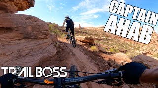
Jewel of the Amasa Back area, relatively new to the other trails. Fun transitions and some great little rock drops. Hymasa is a bit easier, so if you are unsure of your skill, start there, and then climb back up Hymasa to do Captain Ahab.

Trail Supporters
Local Trail Association
Traditionally Indigenous Territory

Recent Activity on Trail

Past Week
  • 2 rides
  • 8 miles average
6 Months
  • 263 rides
  • 10 miles avg distance
All
  • 2,251 rides
  • Last: Jun 16, 2026
c1c2c3c4
January
February
March
April
May
June
July
August
September
October
November
December
Status:
on May 18, 2026
Ideal
Avg: 4.73 (186 votes)
Your vote: 0

view (16,510)
close
3D
Trail Conditions
  • Unknown
  • Snow Groomed
  • Snow Packed
  • Snow Covered
  • Snow Cover Partial
  • Freeze/thaw Cycle
  • Icy
  • Prevalent Mud
  • Wet
  • Variable
  • Ideal
  • Dry
  • Very Dry
Trail Flow (Ridden Direction)
Trailforks scans users ridelogs to determine the most popular direction each trail is ridden. A good flowing trail network will have most trails flowing in a single direction according to their intension.
The colour categories are based on what percentage of riders are riding a trail in its intended direction.
  • > 96%
  • > 90%
  • > 80%
  • > 70%
  • > 50%
  • < 50%
  • bi-directional trail
  • no data
Trail Last Ridden
Trailforks scans ridelogs to determine the last time a trail was ridden.
  • < 2 days
  • < 1 week
  • < 2 weeks
  • < 1 month
  • < 6 months
  • > 6 months
Trail Ridden Direction
The intended direction a trail should be ridden.
  • Downhill Only
  • Downhill Primary
  • Both Directions
  • Uphill Primary
  • Uphill Only
  • One Direction
Contribute Details
Colors indicate trail is missing specified detail.
  • Description
  • Photos
  • Description & Photos
  • Videos
Trail Popularity ?
Trailforks scans ridelogs to determine which trails are ridden the most in the last 9 months. Trails are compared with nearby trails in the same city region with a possible 25 colour shades. Think of this as a heatmap, more rides = more kinetic energy = warmer colors.
  • most popular
  • popular
  • less popular
  • not popular
ATV/ORV/OHV Filter
Max Vehicle Width
inches
US Cell Coverage
Legend
cell carrier legend

Radar Time
Activity Recordings
Trailforks uses anonymized public activity data. ?
Activity Recordings
Trailforks uses anonymized public activity data. ?
Personal Heatmap
Activity Types
all / none
Options
2
Date range month
Winter Trails
Warning A routing network for winter maps does not exist. Selecting trails using the winter trails layer has been disabled.
Missing Trails
Most Popular
Least Popular
Trails are colored based on popularity. The more popular a trail is, the more red. Less popular trails trend towards green.
Jump Magnitude Heatmap
Heatmap of where riders jump on trails. Zoom in to see individual jumps, click circles to view jump details.
BC Backroad Status

Service Road Atlas is a free to use, community-driven service for viewing and creating reports on the numerous back-country service roads around B.C. and Alberta.

map legend
Slope Aspect
Direction the slope faces
Flat N NE E SE S SW W NW
Trails Deemphasized
Trails are shown in grey.
disable
Only show trails with no bike usage.
Enable
Suggested Layers
Based on selected activity type

    Save the current map location and zoom level as your default home location whenever this page is loaded.

    Save
        Directions to captain-ahab-lower trailhead (38.513540, -109.609920)

        Photos

        180 more »
        3,040 |
        Jul 6, 2015 @ 10:19am
        Jul 6, 2015
        2,543 |
        Jan 19, 2018 @ 2:01pm
        Jan 19, 2018
        1,620 |
        Jan 18, 2017 @ 2:33pm
        Jan 18, 2017
        2,595 |
        Jan 21, 2017 @ 11:04pm
        Jan 21, 2017

        Videos

        72 more »
        youtuber Could this be the best trail in Moab?
        10:48 | 1416 | Oct 11, 2022 , Moab
        youtuber Escaping Winter Depression ASMR - Captain Ahab...
        11:39 | 1404 | Feb 4, 2020 , Moab
        youtuber Best Trail In Moab? (Captain Ahab)
        14:09 | 1037 | Oct 7, 2021 , Moab
        youtuber Better Than a Ripmo? (Long Term Ibis Ripley...
        14:28 | 1167 | Dec 15, 2020 , Moab

        Trail Lists

        Routes with this trail

        5.0 8 miles 1,323 ft 13 Loop
        black diamond loop ( )
        4.0 9 miles 1,569 ft 6 Loop
        If you've ridden the classic "life or death" Portal trail in Moab, it's a bit hard to see why Captain Ahab...
        5.0 14 miles 2,106 ft 12 Out & Back
        is an awesome riding area with loads of options. For this route we suggest climbing up either the Cliff...

        50 Reviews & Comments


        We hope you've been enjoying Trailforks!

        Create a FREE account to view trail comments and much more.

        • By toddTF Pro Trailforks & contributors
        • #8992 - 44,216 views

        Frequently Asked Questions About Captain Ahab (lower)

        Where is Captain Ahab (lower) located?
        Captain Ahab (lower) is located in Amasa Back, Moab, Utah, United States. It is part of the Amasa Back trail network. The trailhead is located at coordinates 38.51354, -109.60992.
        How hard is Captain Ahab (lower)?
        Captain Ahab (lower) is rated as Double Black Diamond difficulty. The physical rating is Extreme. The average grade is 5.8%. The climb difficulty is rated Double Black Diamond.
        What is the elevation gain for Captain Ahab (lower)?
        Captain Ahab (lower) has 145 ft of elevation gain. The trail has 748 ft of elevation descent. The elevation ranges from 4,001 ft to 4,651 ft.
        Is Captain Ahab (lower) a point to point trail?
        Yes, Captain Ahab (lower) is a point to point trail. The direction is Downhill Only. The trail type is singletrack.

        Hit the Trail

        Open in App

        Get this trail on your phone instantly.
        open trail in app

        Download Trail

        Save to wishlist, Garmin & download.
        save the trail

        Find Related Routes

        Find routes and users activities that include this trail.
        find routes for this trail

        You must enter a description before submitting.