more stats
2,949 ft
Distance
-537 ft
Descent
00:09:03
Avg time
-538 ft
Altitude change
276 ft
Altitude min
814 ft
Altitude max
814 ft
Altitude start
276 ft
Altitude end
-18.2%
Grade
-61.7%
Grade max
-1.5%
Grade min
2,933 ft
Distance down
00:09:03
Avg time

Car Wreck Details

  • Activities
    • Mountain Bike
    • Hike
    • Trail Running
  • Riding Area
    Aliso and Wood Canyons Wilderness Park
    Aliso Viejo, California
  • Difficulty Rating
  • Voted Difficulty
    Double Black Diamond (12 votes)
  • Local Popularity
    55 in Mountain Biking [+]
    • 65 in Trail Running
    • 95 in Hiking
  • Global Ranking
    #39848 in Mountain Biking [+]
    • #39336 in Trail Running
    • #1377 in Hiking
  • Trail Exposure
    High Risk
  • Trail Type
    Singletrack
  • Bike Type
    DH, AM
  • Climb Difficulty
    Double Black Diamond
  • Physical Rating
    Hard
  • Trail Visibility
    Always easy to follow
  • Season
    all year
  • eBike Allowed
  • TTFs on Trail
    Berm, Drop, Jump, Rock Face, Rock Garden
  • Land Owner
    OC Parks

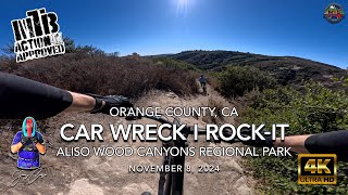
Steep single track (approx. 19%) with large and technical rock garden at the end. Called Car Wreck because there is an old wrecked car at the bottom just after the rock garden.

Access Info

Trail Starts near the top of Mathis. It is sign posted.

Local Trail Association
Traditionally Indigenous Territory

Recent Activity on Trail

Past Week
  • 0 rides
  •  
6 Months
  • 18 rides
  • 13 miles avg distance
All
  • 376 rides
  • Last: Jun 15, 2026
c1c2c3c4
January
February
March
April
May
June
July
August
September
October
November
December
update trails status or condition

Car Wreck Trail Reports

statusdatedescription
Jun 10, 2026 @ 11:06pm (America/Los_Angeles)
Jun 10, 2026
rides fine, the last rock garden is experiencing some serious erosion
Mar 16, 2026 @ 6:30pm (America/Los_Angeles)
Mar 16, 2026
I rolled past it hours ago and the sign said "Caution Uneven Trail," its not closed but idk how it is
Mar 6, 2026 @ 7:38am (America/Los_Angeles)
Mar 6, 2026
There is a sign at the entrance saying the trail is closed for now because of dangerous conditions. No details are provided.
May 31, 2025 @ 8:41am
May 31, 2025
That is more a Bike Wreck after you made it down. Hardtail or regular trail bikes getting hammered badly. A full size downhill bike fits better
Oct 10, 2024 @ 1:34pm
Oct 10, 2024
Dry and dusty like everything on the mountain.
more »
Status:
on Jun 10, 2026
Variable
Avg: 4.5 (31 votes)
Your vote: 0

view (5,351)
close
3D
Trail Conditions
  • Unknown
  • Snow Groomed
  • Snow Packed
  • Snow Covered
  • Snow Cover Partial
  • Freeze/thaw Cycle
  • Icy
  • Prevalent Mud
  • Wet
  • Variable
  • Ideal
  • Dry
  • Very Dry
Trail Flow (Ridden Direction)
Trailforks scans users ridelogs to determine the most popular direction each trail is ridden. A good flowing trail network will have most trails flowing in a single direction according to their intension.
The colour categories are based on what percentage of riders are riding a trail in its intended direction.
  • > 96%
  • > 90%
  • > 80%
  • > 70%
  • > 50%
  • < 50%
  • bi-directional trail
  • no data
Trail Last Ridden
Trailforks scans ridelogs to determine the last time a trail was ridden.
  • < 2 days
  • < 1 week
  • < 2 weeks
  • < 1 month
  • < 6 months
  • > 6 months
Trail Ridden Direction
The intended direction a trail should be ridden.
  • Downhill Only
  • Downhill Primary
  • Both Directions
  • Uphill Primary
  • Uphill Only
  • One Direction
Contribute Details
Colors indicate trail is missing specified detail.
  • Description
  • Photos
  • Description & Photos
  • Videos
Trail Popularity ?
Trailforks scans ridelogs to determine which trails are ridden the most in the last 9 months. Trails are compared with nearby trails in the same city region with a possible 25 colour shades. Think of this as a heatmap, more rides = more kinetic energy = warmer colors.
  • most popular
  • popular
  • less popular
  • not popular
ATV/ORV/OHV Filter
Max Vehicle Width
inches
US Cell Coverage
Legend
cell carrier legend

Radar Time
Activity Recordings
Trailforks uses anonymized public activity data. ?
Activity Recordings
Trailforks uses anonymized public activity data. ?
Personal Heatmap
Activity Types
all / none
Options
2
Date range month
Winter Trails
Warning A routing network for winter maps does not exist. Selecting trails using the winter trails layer has been disabled.
Missing Trails
Most Popular
Least Popular
Trails are colored based on popularity. The more popular a trail is, the more red. Less popular trails trend towards green.
Jump Magnitude Heatmap
Heatmap of where riders jump on trails. Zoom in to see individual jumps, click circles to view jump details.
BC Backroad Status

Service Road Atlas is a free to use, community-driven service for viewing and creating reports on the numerous back-country service roads around B.C. and Alberta.

map legend
Slope Aspect
Direction the slope faces
Flat N NE E SE S SW W NW
Trails Deemphasized
Trails are shown in grey.
disable
Only show trails with no bike usage.
Enable
Suggested Layers
Based on selected activity type

    Save the current map location and zoom level as your default home location whenever this page is loaded.

    Save
        Directions to car-wreck trailhead (33.563750, -117.755770)

        Photos

        36 more »
        187 |
        Apr 8, 2024 @ 1:35pm
        Apr 8, 2024
        91 |
        Oct 6, 2023 @ 1:41pm
        Oct 6, 2023
        132 |
        Nov 19, 2022 @ 6:09pm
        Nov 19, 2022
        176 |
        Nov 19, 2022 @ 6:09pm
        Nov 19, 2022

        Videos

        62 more »
        youtuber WrecKing ALISO CANYON | Mountain Biking Orange...
        6:25 | 825 | Nov 12, 2018 , Aliso Viejo
        youtuber MTB Riding Car Wreck and Rock-It, Aliso Wood...
        16:32 | 189 | Nov 10, 2024 , Aliso Viejo
        youtuber We Are Back In SoCal and It's Time for Change!...
        11:58 | 273 | Dec 7, 2022 , Aliso Viejo
        youtuber In my 50s and still taking risks.
        13:24 | 106 | Apr 7, 2025 , Aliso Viejo

        Routes with this trail

        13 miles 2,201 ft 6 Loop
        This is a longer & gnarlier route. Watch out for Mentally Sensitive and Car Wreck, as they can be...
        13 miles 1,333 ft 7
        cholla to lynx, coyote run, then mathis to car wreck I kinda messed up making the map, so it shows taking...
        23 miles 3,273 ft 21 Loop
        Three wilderness parks and four or five descents. Alwut is an optional add on that I would recommend...

        8 Reviews & Comments


        We hope you've been enjoying Trailforks!

        Create a FREE account to view trail comments and much more.

        • By iamenduro14 & contributors
        • #7474 - 10,958 views

        Frequently Asked Questions About Car Wreck

        Where is Car Wreck located?
        Car Wreck is located in Aliso and Wood Canyons Wilderness Park, Aliso Viejo, California, United States. It is part of the Aliso and Wood Canyons Wilderness Park trail network. The trailhead is located at coordinates 33.56375, -117.75577.
        How hard is Car Wreck?
        Car Wreck is rated as Double Black Diamond difficulty. The physical rating is Hard. The average grade is 18.2%. The climb difficulty is rated Double Black Diamond.
        What is the elevation gain for Car Wreck?
        The trail has 537 ft of elevation descent. The elevation ranges from 276 ft to 814 ft.
        How long is Car Wreck?
        Car Wreck is 2,949 ft long. The trail type is singletrack.

        Hit the Trail

        Open in App

        Get this trail on your phone instantly.
        open trail in app

        Download Trail

        Save to wishlist, Garmin & download.
        save the trail

        Find Related Routes

        Find routes and users activities that include this trail.
        find routes for this trail

        You must enter a description before submitting.