



Open in App
Get this trail on your phone instantly.

The Carbon River Trail now begins at the Carbon River entrance at the northwest border of the park. This is due to flooding which altered the roadbed and closed the road to vehicles. Bikes are allowed on the portion of the trail on the old road bed, from the Carbon River Entrance to Ipsut Creek Campground. Bikes are not allowed on trails past the campground. Given that this trail follows an old roadbed, it's quite easy-going. The grade stays consistent at ~2%.
Like the now closed Westside Road, the Carbon River Road is one of the few places mountain bikes are allowed within the national park. Park officials will be putting bike racks in place at the trailheads along the Carbon River Road, which will allow for the unique experience of bike and hike outings.
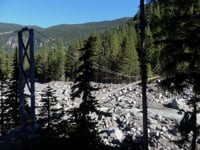
The Ipsut Creek Car Campground is still open, but now accessible to just hikers and bikers. If you plan on spending a night at this delightful campground on the Carbon River, pick up a backcountry permit at the Carbon River Wilderness Information Center near the Ranger Station. From Ipsut Creek you can hike 3.2 miles on the Wonderland Trail to a suspension bridge over the Carbon River at the snout of the Carbon Glacier. At an elevation of 3,500 feet, Carbon is the lowest elevation glacier in the Lower Forty-eight and at over five miles long-the longest glacier within the contiguous states as well.
| c1 | c2 | c3 | c4 |
|---|---|---|---|
January | February | March | April |
May | June | July | August |
September | October | November | December |


Service Road Atlas is a free to use, community-driven service for viewing and creating reports on the numerous back-country service roads around B.C. and Alberta.
Save the current map location and zoom level as your default home location whenever this page is loaded.
Save
We hope you've been enjoying Trailforks!
Create a FREE account to view trail comments and much more.
 & contributors
You must enter a description before submitting.

