more stats
1.7 miles
Distance
207 ft
Climb
-173 ft
Descent
00:17:33
Avg time
35 ft
Altitude change
4,196 ft
Altitude min
4,320 ft
Altitude max
4,281 ft
Altitude start
4,318 ft
Altitude end
0.4%
Grade
-33.6%
Grade max
15.2%
Grade min
4,081 ft
Distance climb
2,274 ft
Distance down
2,497 ft
Distance flat
00:17:33
Avg time

Carroll Canyon Details

  • Activities
    • Mountain Bike
    • Horse
    • Hike
    • Trail Running
  • Riding Area
    Carroll Canyon
    Sedona, Arizona
  • Ref Number
    #207
  • Difficulty Rating
  • Voted Difficulty
    Blue (1 vote)
  • Local Popularity
    65 in Mountain Biking [+]
    • 70 in Trail Running
    • 65 in Hiking
    • 5 in Horseback
  • Global Ranking
    #38776 in Mountain Biking [+]
    • #81930 in Trail Running
    • #89247 in Hiking
  • Trail Type
    Singletrack
  • Direction
    Both Directions
  • Dogs Allowed
    Yes
  • eBike Allowed

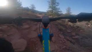
Intermediate 80%, advanced 15% and 5% expert, 1.7 mile MTB trail which is a bi-directional singletrack that is an up and down trail with a number of technical sections that keep you on your toes. The trail tread is mostly packed dirt mixed with rocks and several rocky sections and dry wash crossings that lesser skilled riders will find difficult to ride. There is no preferred direction and the trail is a sometimes used for several other fun loops.

Trail Supporters

  • USFS
    Land Manager
Local Trail Association

Recent Activity on Trail

Past Week
  • 0 rides
  •  
6 Months
  • 63 rides
  • 11 miles avg distance
All
  • 566 rides
  • Last: Jun 28, 2026
c1c2c3c4
January
February
March
April
May
June
July
August
September
October
November
December
update trails status or condition

Carroll Canyon Trail Reports

statusdatedescription
Apr 29, 2025 @ 10:29am
Apr 29, 2025
Mar 6, 2025 @ 9:37am
Mar 6, 2025
Mar 6, 2025 @ 9:24am
Mar 6, 2025
Feb 16, 2025 @ 1:04pm
Feb 16, 2025
Dec 11, 2024 @ 3:05pm
Dec 11, 2024
The initial 13-17% grade on this is going to be a challenge for anyone. While super short and not a big deal it’s definitely going to take most...
more »
Status:
on Apr 29, 2025
Ideal
Avg: 3.61 (17 votes)
Your vote: 0

view (2,470)
close
3D
Trail Conditions
  • Unknown
  • Snow Groomed
  • Snow Packed
  • Snow Covered
  • Snow Cover Partial
  • Freeze/thaw Cycle
  • Icy
  • Prevalent Mud
  • Wet
  • Variable
  • Ideal
  • Dry
  • Very Dry
Trail Flow (Ridden Direction)
Trailforks scans users ridelogs to determine the most popular direction each trail is ridden. A good flowing trail network will have most trails flowing in a single direction according to their intension.
The colour categories are based on what percentage of riders are riding a trail in its intended direction.
  • > 96%
  • > 90%
  • > 80%
  • > 70%
  • > 50%
  • < 50%
  • bi-directional trail
  • no data
Trail Last Ridden
Trailforks scans ridelogs to determine the last time a trail was ridden.
  • < 2 days
  • < 1 week
  • < 2 weeks
  • < 1 month
  • < 6 months
  • > 6 months
Trail Ridden Direction
The intended direction a trail should be ridden.
  • Downhill Only
  • Downhill Primary
  • Both Directions
  • Uphill Primary
  • Uphill Only
  • One Direction
Contribute Details
Colors indicate trail is missing specified detail.
  • Description
  • Photos
  • Description & Photos
  • Videos
Trail Popularity ?
Trailforks scans ridelogs to determine which trails are ridden the most in the last 9 months. Trails are compared with nearby trails in the same city region with a possible 25 colour shades. Think of this as a heatmap, more rides = more kinetic energy = warmer colors.
  • most popular
  • popular
  • less popular
  • not popular
ATV/ORV/OHV Filter
Max Vehicle Width
inches
US Cell Coverage
Legend
cell carrier legend

Radar Time
Activity Recordings
Trailforks uses anonymized public activity data. ?
Activity Recordings
Trailforks uses anonymized public activity data. ?
Personal Heatmap
Activity Types
all / none
Options
2
Date range month
Winter Trails
Warning A routing network for winter maps does not exist. Selecting trails using the winter trails layer has been disabled.
Missing Trails
Most Popular
Least Popular
Trails are colored based on popularity. The more popular a trail is, the more red. Less popular trails trend towards green.
Jump Magnitude Heatmap
Heatmap of where riders jump on trails. Zoom in to see individual jumps, click circles to view jump details.
BC Backroad Status

Service Road Atlas is a free to use, community-driven service for viewing and creating reports on the numerous back-country service roads around B.C. and Alberta.

map legend
Slope Aspect
Direction the slope faces
Flat N NE E SE S SW W NW
Trails Deemphasized
Trails are shown in grey.
disable
Only show trails with no bike usage.
Enable
Suggested Layers
Based on selected activity type

    Save the current map location and zoom level as your default home location whenever this page is loaded.

    Save
        Directions to carroll-canyon trailhead (34.842770, -111.812140)

        Photos

        11 more »
        268 |
        Oct 17, 2020 @ 6:30pm
        Oct 17, 2020
        194 |
        Nov 23, 2018 @ 3:42pm
        Nov 23, 2018
        116 |
        Apr 8, 2023 @ 10:30pm
        Apr 8, 2023
        135 |
        Oct 17, 2020 @ 6:31pm
        Oct 17, 2020

        Videos

        3 more »
        Sedona MTB - Carroll Canyon
        7:52 | 116 | Feb 20, 2025 , Sedona
        Carroll Canyon
        6:41 | 181 | Aug 28, 2022 , Sedona
        Carroll Canyon
        6:38 | 599 | Jan 16, 2019 , Sedona

        Routes with this trail

        4.0 11 miles 1,487 ft 9 Loop
        This loop is a butterfly, so you will end up climbing twice. However, that is well worth it for the trails...
        3.2 30 miles 3,603 ft 56 Loop
        This is a classic Sedona high tech route using some of the iconic trails in the area: , Hogs & . This...
        10 miles 1,170 ft 12 Point to Point
        This route is mostly black diamond with a few steep double black diamond sections, recommended for...

        3 Reviews & Comments


        We hope you've been enjoying Trailforks!

        Create a FREE account to view trail comments and much more.

        Nearby Trails

        • By toddTF Pro Trailforks & contributors
        • #14558 - 4,850 views

        Frequently Asked Questions About Carroll Canyon

        Where is Carroll Canyon located?
        Carroll Canyon is located in Carroll Canyon, Sedona, Arizona, United States. It is part of the Carroll Canyon trail network. The trailhead is located at coordinates 34.84277, -111.81214.
        How hard is Carroll Canyon?
        Carroll Canyon is rated as Blue difficulty. The average grade is 0.4%.
        What is the elevation gain for Carroll Canyon?
        Carroll Canyon has 207 ft of elevation gain. The trail has 173 ft of elevation descent. The elevation ranges from 4,196 ft to 4,320 ft.
        Is Carroll Canyon a point to point trail?
        Carroll Canyon is not a point to point trail. The direction is Both Directions. The trail type is singletrack.

        Hit the Trail

        Open in App

        Get this trail on your phone instantly.
        open trail in app

        Download Trail

        Save to wishlist, Garmin & download.
        save the trail

        Find Related Routes

        Find routes and users activities that include this trail.
        find routes for this trail

        You must enter a description before submitting.