


Open in App
Get this trail on your phone instantly.

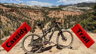
The Cassidy Trail is a little-known but awesome ride. The trail is upper-intermediate technical, moderate aerobic. Trailhead is at 7200 feet, rising to 7900. The trail starts on Highway 12 in Red Canyon, and connects to the Casto Canyon and Losee Canyon trails. Ride options include out-and-back (to Braxton Point 5.5 miles round trip), loop with Losee Canyon (14 miles), or a loop with Casto Canyon (20 miles).
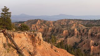
The Cassidy Trail lies on Claron Formation limestone, creating colorful rock formations. Photos by Bruce, July 31, 2004.
The Cassidy Trail is a lot like Thunder Mountain, which is located just on the other side of highway 12. This is probably the greatest ride you've never heard of. Done as a loop (or shuttle ride) up Cassidy then down Losee Canyon, it's a world-class ride.
The scenery is colorful limestone with a sprinkling of manzanita, cedar, long-leaf and bristlecone pine. Temperatures are warm but tolerable at mid-day in summer.
| c1 | c2 | c3 | c4 |
|---|---|---|---|
January | February | March | April |
May | June | July | August |
September | October | November | December |

Service Road Atlas is a free to use, community-driven service for viewing and creating reports on the numerous back-country service roads around B.C. and Alberta.
Save the current map location and zoom level as your default home location whenever this page is loaded.
SaveWe hope you've been enjoying Trailforks!
Create a FREE account to view trail comments and much more.
You must enter a description before submitting.

