more stats
2.4 miles
Distance
114 ft
Climb
-455 ft
Descent
00:31:44
Avg time
-342 ft
Altitude change
1,766 ft
Altitude min
2,151 ft
Altitude max
2,148 ft
Altitude start
1,808 ft
Altitude end
-2.7%
Grade
-27.4%
Grade max
17.7%
Grade min
2,976 ft
Distance climb
2 miles
Distance down
791 ft
Distance flat
00:31:44
Avg time

Catamount Trail (Mid) Details

  • Activities
    • Mountain Bike
    • Adaptive Bike
    • Winter Fat Bike
    • Hike
    • Trail Running
  • Riding Area
    Silver Falls State Park
    Salem, Oregon
  • Difficulty Rating
  • Local Popularity
    100 in Mountain Biking [+]
    • 95 in Trail Running
    • 90 in Hiking
  • Global Ranking
    #22024 in Mountain Biking [+]
    • #252 in Trail Running
    • #1396 in Hiking
  • Trail Type
    Singletrack
  • Bike Type
    DH, AM, XC, Fat, Adaptive MTB
  • Direction
    Downhill Primary
    Popular Direction Shown
  • Climb Difficulty
    Blue
  • Physical Rating
    Moderate
  • Trail Visibility
    Always easy to follow
  • Dogs Allowed
    Yes
  • TTFs on Trail
    Berm, Bridge, Drop, Jump, Log Ride
  • Land Owner
    Silver Falls State Park

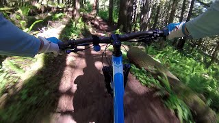
This trail runs through beautiful ancient forests, passes huge fallen trees, crosses several streams, and offers a very unique riding experience to a wide range of riders. While intended to be ridden downhill, east to west, the trail can be ridden uphill-- excluding the uppermost section which is marked for downhill only.
Optional features, such as small stump kickers, drops, and a few log rides increase the downhill rush for riders perusing more of a thrill. These are easily navigated at a lower speeds, or bypassed, for people who want a mellower ride. Steep sections followed by short punchy climbs encourage momentum, but to maintain a high speed your fitness will be tested, especially towards the lower sections.

Built entirely by volunteers, the trail is very impressive. While most definitely having technical and demanding aspects, it is not overly excruciating, balancing rooty and rocky raw trail sections with smooth and polished flow.
However you choose to ride it, you will not be disappointed with the scenery

Access Info

Park at Trailhead 214 (A parking pass for Silver Falls State Park or an Annual Forest Pass is required. You'll have to drive a little ways down the Silver Falls Highway to purchase a pass at one of the falls parking lots. You can also buy them online)
The trail can be climbed up by following the signs across the road, or you can climb the gravel road (Lookout Mountain Road) to reach the top. State Park may enforce parking fee ($5/day or $30/yr).

Adaptive Bike Info
aMTB Blue Rating: Intermediate features and steeper terrain.

Some off-camber, pinch points, and switchbacks requiring multi-point turns

Trail Supporters
  • BLM
    BLM
    Land Manager
  • past supporters

  • REI
    REI

    2016 - 2017
    Sponsor
Local Trail Association
Traditionally Indigenous Territory

Recent Activity on Trail

Past Week
  • 9 rides
  • 16 miles average
6 Months
  • 164 rides
  • 14 miles avg distance
All
  • 1,170 rides
  • Last: Jun 19, 2026
c1c2c3c4
January
February
March
April
May
June
July
August
September
October
November
December
Status:
on May 21, 2026
Variable
Avg: 4.28 (19 votes)
Your vote: 0

view (3,522)
close
3D
Trail Conditions
  • Unknown
  • Snow Groomed
  • Snow Packed
  • Snow Covered
  • Snow Cover Partial
  • Freeze/thaw Cycle
  • Icy
  • Prevalent Mud
  • Wet
  • Variable
  • Ideal
  • Dry
  • Very Dry
Trail Flow (Ridden Direction)
Trailforks scans users ridelogs to determine the most popular direction each trail is ridden. A good flowing trail network will have most trails flowing in a single direction according to their intension.
The colour categories are based on what percentage of riders are riding a trail in its intended direction.
  • > 96%
  • > 90%
  • > 80%
  • > 70%
  • > 50%
  • < 50%
  • bi-directional trail
  • no data
Trail Last Ridden
Trailforks scans ridelogs to determine the last time a trail was ridden.
  • < 2 days
  • < 1 week
  • < 2 weeks
  • < 1 month
  • < 6 months
  • > 6 months
Trail Ridden Direction
The intended direction a trail should be ridden.
  • Downhill Only
  • Downhill Primary
  • Both Directions
  • Uphill Primary
  • Uphill Only
  • One Direction
Contribute Details
Colors indicate trail is missing specified detail.
  • Description
  • Photos
  • Description & Photos
  • Videos
Trail Popularity ?
Trailforks scans ridelogs to determine which trails are ridden the most in the last 9 months. Trails are compared with nearby trails in the same city region with a possible 25 colour shades. Think of this as a heatmap, more rides = more kinetic energy = warmer colors.
  • most popular
  • popular
  • less popular
  • not popular
ATV/ORV/OHV Filter
Max Vehicle Width
inches
US Cell Coverage
Legend
cell carrier legend

Radar Time
Activity Recordings
Trailforks uses anonymized public activity data. ?
Activity Recordings
Trailforks uses anonymized public activity data. ?
Personal Heatmap
Activity Types
all / none
Options
2
Date range month
Winter Trails
Warning A routing network for winter maps does not exist. Selecting trails using the winter trails layer has been disabled.
Missing Trails
Most Popular
Least Popular
Trails are colored based on popularity. The more popular a trail is, the more red. Less popular trails trend towards green.
Jump Magnitude Heatmap
Heatmap of where riders jump on trails. Zoom in to see individual jumps, click circles to view jump details.
BC Backroad Status

Service Road Atlas is a free to use, community-driven service for viewing and creating reports on the numerous back-country service roads around B.C. and Alberta.

map legend
Slope Aspect
Direction the slope faces
Flat N NE E SE S SW W NW
Trails Deemphasized
Trails are shown in grey.
disable
Only show trails with no bike usage.
Enable
Suggested Layers
Based on selected activity type

    Save the current map location and zoom level as your default home location whenever this page is loaded.

    Save
        Directions to catamount-trail-mid trailhead (44.833760, -122.614020)

        Photos

        65 more »
        476 |
        May 24, 2020 @ 11:25am
        May 24, 2020
        75 |
        Apr 19, 2025 @ 12:34pm
        Apr 19, 2025
        79 |
        Apr 19, 2025 @ 12:34pm
        Apr 19, 2025
        138 |
        Jul 15, 2024 @ 8:39am
        Jul 15, 2024

        Videos

        4 more »
        Catamount Trail (Mid) UNCUT - Adaptive MTB -...
        28:11 | 211 | Oct 1, 2024 , Salem
        Catamount Trail 6 24 22
        3:10 | 618 | Jun 25, 2022 , Salem
        Catamount Trail in Silver Falls State Park
        27:28 | 1155 | Sep 21, 2020 , Salem
        SATA Catamount Trail
        2:42 | 1343 | Sep 28, 2016 , Salem

        Routes with this trail

        4.7 9 miles 1,268 ft 11 Loop
        Park at the Conference Center Parking Lot (as mapped), clockwise direction recommended. Alternatively,...
        5.0 9 miles 810 ft 3 Loop
        This route takes you to the top of Lookout Mountain Road where the Catamount starts.
        4.0 9 miles 912 ft 4 Loop
        The most common Catamount Lap.

        Trail Events

        19 Reviews & Comments


        We hope you've been enjoying Trailforks!

        Create a FREE account to view trail comments and much more.

        Frequently Asked Questions About Catamount Trail (Mid)

        Where is Catamount Trail (Mid) located?
        Catamount Trail (Mid) is located in Silver Falls State Park, Salem, Oregon, United States. It is part of the Silver Falls State Park trail network. The trailhead is located at coordinates 44.83376, -122.61402.
        How hard is Catamount Trail (Mid)?
        Catamount Trail (Mid) is rated as Blue difficulty. The physical rating is Moderate. The average grade is 2.7%. The climb difficulty is rated Blue.
        What is the elevation gain for Catamount Trail (Mid)?
        Catamount Trail (Mid) has 35 m of elevation gain. The trail has 139 m of elevation descent. The elevation ranges from 538 m to 656 m.
        Is Catamount Trail (Mid) a point to point trail?
        Catamount Trail (Mid) is not a point to point trail. The direction is Downhill Primary. The trail type is singletrack.

        Hit the Trail

        Open in App

        Get this trail on your phone instantly.
        open trail in app

        Download Trail

        Save to wishlist, Garmin & download.
        save the trail

        Find Related Routes

        Find routes and users activities that include this trail.
        find routes for this trail

        You must enter a description before submitting.