more stats
1.9 miles
Distance
141 ft
Climb
-1,065 ft
Descent
00:20:46
Avg time
-924 ft
Altitude change
683 ft
Altitude min
1,702 ft
Altitude max
1,608 ft
Altitude start
683 ft
Altitude end
-9.139%
Grade
-34.425%
Grade max
24.562%
Grade min
1,438 ft
Distance climb
2 miles
Distance down
311 ft
Distance flat
00:20:46
Avg time

Cathedral Details

  • Activities
    • Mountain Bike
    • Hike
    • Trail Running
  • Riding Area
    Cathedral City
    , California
  • Difficulty Rating
  • Voted Difficulty
    Black Diamond (3 votes)
  • Local Popularity
    90 in Mountain Biking [+]
    • 85 in Trail Running
    • 5 in Hiking
  • Global Ranking
    #80674 in Mountain Biking [+]
    • #69009 in Trail Running
    • #217459 in Hiking
  • Trail Type
    Singletrack
  • Bike Type
    AM
  • Direction
    Downhill Primary
    Popular Direction Shown
  • Dogs Allowed
    Yes

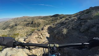
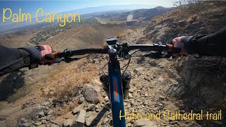
Rocky switchbacks and narrow bench makes this a really fun tech decent. nTight turns with some no-fall zones tossed in make it spicy. No mandatory drops or airs but lots of chunk keep you on your toes and energy management is needed to avoid going off the trail (and possibly the side of the mountain).

Trail Supporters
  • BLM
    BLM
    Land Manager
Local Trail Association
Traditionally Indigenous Territory

Recent Activity on Trail

Past Week
  • 0 rides
  •  
6 Months
  • 22 rides
  • 14 miles avg distance
All
  • 134 rides
  • Last: Jun 23, 2026
c1c2c3c4
January
February
March
April
May
June
July
August
September
October
November
December
update trails status or condition

Cathedral Trail Reports

statusdatedescription
Jan 12, 2026 @ 6:07pm (America/Los_Angeles)
Jan 12, 2026
Great condition will all the crazy gnar! Good times!
Mar 23, 2025 @ 6:33pm
Mar 23, 2025
Riding really nice, I think the tech-geeks would say it's cleaned up and a bit too easy, but right now most of those more technical sections in...
Mar 1, 2025 @ 8:16am
Mar 1, 2025
Good conditions overall, still the usual loose rocks and sand
Mar 3, 2024 @ 7:37pm
Mar 3, 2024
Overall in great shape but lots of loose rocks. Recent rains have tamped down the dust.
Apr 10, 2023 @ 5:02pm
Apr 10, 2023
more »
Status:
on Jan 12, 2026
Ideal
Avg: 3.93 (11 votes)
Your vote: 0

view (1,327)
close
3D
Trail Conditions
  • Unknown
  • Snow Groomed
  • Snow Packed
  • Snow Covered
  • Snow Cover Partial
  • Freeze/thaw Cycle
  • Icy
  • Prevalent Mud
  • Wet
  • Variable
  • Ideal
  • Dry
  • Very Dry
Trail Flow (Ridden Direction)
Trailforks scans users ridelogs to determine the most popular direction each trail is ridden. A good flowing trail network will have most trails flowing in a single direction according to their intension.
The colour categories are based on what percentage of riders are riding a trail in its intended direction.
  • > 96%
  • > 90%
  • > 80%
  • > 70%
  • > 50%
  • < 50%
  • bi-directional trail
  • no data
Trail Last Ridden
Trailforks scans ridelogs to determine the last time a trail was ridden.
  • < 2 days
  • < 1 week
  • < 2 weeks
  • < 1 month
  • < 6 months
  • > 6 months
Trail Ridden Direction
The intended direction a trail should be ridden.
  • Downhill Only
  • Downhill Primary
  • Both Directions
  • Uphill Primary
  • Uphill Only
  • One Direction
Contribute Details
Colors indicate trail is missing specified detail.
  • Description
  • Photos
  • Description & Photos
  • Videos
Trail Popularity ?
Trailforks scans ridelogs to determine which trails are ridden the most in the last 9 months. Trails are compared with nearby trails in the same city region with a possible 25 colour shades. Think of this as a heatmap, more rides = more kinetic energy = warmer colors.
  • most popular
  • popular
  • less popular
  • not popular
ATV/ORV/OHV Filter
Max Vehicle Width
inches
US Cell Coverage
Legend
cell carrier legend

Radar Time
Activity Recordings
Trailforks uses anonymized public activity data. ?
Activity Recordings
Trailforks uses anonymized public activity data. ?
Personal Heatmap
Activity Types
all / none
Options
2
Date range month
Winter Trails
Warning A routing network for winter maps does not exist. Selecting trails using the winter trails layer has been disabled.
Missing Trails
Most Popular
Least Popular
Trails are colored based on popularity. The more popular a trail is, the more red. Less popular trails trend towards green.
Jump Magnitude Heatmap
Heatmap of where riders jump on trails. Zoom in to see individual jumps, click circles to view jump details.
BC Backroad Status

Service Road Atlas is a free to use, community-driven service for viewing and creating reports on the numerous back-country service roads around B.C. and Alberta.

map legend
Slope Aspect
Direction the slope faces
Flat N NE E SE S SW W NW
Trails Deemphasized
Trails are shown in grey.
disable
Only show trails with no bike usage.
Enable
Suggested Layers
Based on selected activity type

    Save the current map location and zoom level as your default home location whenever this page is loaded.

    Save
        Directions to cathedral-125626 trailhead (33.747740, -116.493200)

        Photos

        10 more »
        75 |
        Mar 4, 2024 @ 5:18pm
        Mar 4, 2024
        56 |
        Apr 11, 2023 @ 2:44pm
        Apr 11, 2023
        50 |
        Apr 11, 2023 @ 2:44pm
        Apr 11, 2023
        63 |
        Apr 11, 2023 @ 2:44pm
        Apr 11, 2023

        Videos

        9 more »
        youtuber Desert Riding and a channel update?
        6:23 | 329 | May 25, 2022 , Cathedral City
        youtuber Palm Canyon Epic Mega Guide | Part 9: Cathedral
        13:09 | 427 | Jul 31, 2020 , Cathedral City
        Palm canyon trail hahn and cathedral trail...
        7:52 | 60 | Jun 29, 2025 , Cathedral City
        Palm Canyon Epic Guide - Cathedral Trail
        37:09 | 92 | Mar 27, 2024 , Cathedral City

        Routes with this trail

        11 miles 2,332 ft 4
        Short but steep route to do when it's not hot.
        25 miles 1,948 ft 7 Shuttled
        PCE To Cat City - Shuttled to start of PCE

        5 Reviews & Comments


        We hope you've been enjoying Trailforks!

        Create a FREE account to view trail comments and much more.

        • By crazybearbikesTF Pro & contributors
        • #125626 - 3,996 views

        Frequently Asked Questions About Cathedral

        Where is Cathedral located?
        Cathedral is located in Cathedral City, California, United States. It is part of the Cathedral City trail network. The trailhead is located at coordinates 33.74774, -116.4932.
        How hard is Cathedral?
        Cathedral is rated as Black Diamond difficulty. The average grade is 9.139%.
        What is the elevation gain for Cathedral?
        Cathedral has 141 ft of elevation gain. The trail has 1,065 ft of elevation descent. The elevation ranges from 683 ft to 1,702 ft.
        Is Cathedral a point to point trail?
        Cathedral is not a point to point trail. The direction is Downhill Primary. The trail type is singletrack.

        Hit the Trail

        Open in App

        Get this trail on your phone instantly.
        open trail in app

        Download Trail

        Save to wishlist, Garmin & download.
        save the trail

        Find Related Routes

        Find routes and users activities that include this trail.
        find routes for this trail

        You must enter a description before submitting.