more stats
1.4 miles
Distance
-663 ft
Descent
00:14:21
Avg time
-663 ft
Altitude change
725 ft
Altitude min
1,388 ft
Altitude max
1,388 ft
Altitude start
725 ft
Altitude end
-8.689%
Grade
-29.013%
Grade max
2.1%
Grade min
107 ft
Distance climb
1 mile
Distance down
468 ft
Distance flat
00:14:21
Avg time

Cavedale Details

  • Activities
    • Mountain Bike
    • Hike
    • Trail Running
  • Difficulty Rating
  • Voted Difficulty
    Black (3 votes)
  • Local Popularity
    75 in Mountain Biking [+]
    • 75 in Trail Running
    • 100 in Hiking
  • Global Ranking
    #52064 in Mountain Biking [+]
    • #62779 in Trail Running
    • #1958 in Hiking
  • Trail Type
    Singletrack
  • Bike Type
    AM
  • Direction
    Downhill Primary
    Popular Direction Shown
  • Climb Difficulty
    Black Diamond
  • Physical Rating
    Extreme
  • Season
    All year
  • Dogs Allowed
    Yes
  • eBike Allowed
    Yes up to Class 1
  • TTFs on Trail
    Rock Garden
  • Ride in Rain
    Yes

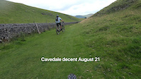
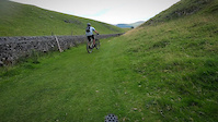
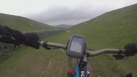
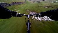
Starts off with some sweet singletrack for about 1/3 of a mile then turns in to one steep extreme natural rock garden with usually a river running down it .Best ridden in off peak times as there tends to be a lot of walkers coming up the track.

Access Info

Best ridden as part of a loop and riding with a local who knows the area

Recent Activity on Trail

Past Week
  • 0 rides
  •  
6 Months
  • 16 rides
  • 25 miles avg distance
All
  • 103 rides
  • Last: Jun 16, 2026
c1c2c3c4
January
February
March
April
May
June
July
August
September
October
November
December
update trails status or condition

Cavedale Trail Reports

Status:
on May 22, 2026
Dry
Avg: 4.35 (5 votes)
Your vote: 0

view (1,242)
close
3D
Trail Conditions
  • Unknown
  • Snow Groomed
  • Snow Packed
  • Snow Covered
  • Snow Cover Partial
  • Freeze/thaw Cycle
  • Icy
  • Prevalent Mud
  • Wet
  • Variable
  • Ideal
  • Dry
  • Very Dry
Trail Flow (Ridden Direction)
Trailforks scans users ridelogs to determine the most popular direction each trail is ridden. A good flowing trail network will have most trails flowing in a single direction according to their intension.
The colour categories are based on what percentage of riders are riding a trail in its intended direction.
  • > 96%
  • > 90%
  • > 80%
  • > 70%
  • > 50%
  • < 50%
  • bi-directional trail
  • no data
Trail Last Ridden
Trailforks scans ridelogs to determine the last time a trail was ridden.
  • < 2 days
  • < 1 week
  • < 2 weeks
  • < 1 month
  • < 6 months
  • > 6 months
Trail Ridden Direction
The intended direction a trail should be ridden.
  • Downhill Only
  • Downhill Primary
  • Both Directions
  • Uphill Primary
  • Uphill Only
  • One Direction
Contribute Details
Colors indicate trail is missing specified detail.
  • Description
  • Photos
  • Description & Photos
  • Videos
Trail Popularity ?
Trailforks scans ridelogs to determine which trails are ridden the most in the last 9 months. Trails are compared with nearby trails in the same city region with a possible 25 colour shades. Think of this as a heatmap, more rides = more kinetic energy = warmer colors.
  • most popular
  • popular
  • less popular
  • not popular
ATV/ORV/OHV Filter
Max Vehicle Width
inches
US Cell Coverage
Legend
cell carrier legend

Radar Time
Activity Recordings
Trailforks uses anonymized public activity data. ?
Activity Recordings
Trailforks uses anonymized public activity data. ?
Personal Heatmap
Activity Types
all / none
Options
2
Date range month
Winter Trails
Warning A routing network for winter maps does not exist. Selecting trails using the winter trails layer has been disabled.
Missing Trails
Most Popular
Least Popular
Trails are colored based on popularity. The more popular a trail is, the more red. Less popular trails trend towards green.
Jump Magnitude Heatmap
Heatmap of where riders jump on trails. Zoom in to see individual jumps, click circles to view jump details.
BC Backroad Status

Service Road Atlas is a free to use, community-driven service for viewing and creating reports on the numerous back-country service roads around B.C. and Alberta.

map legend
Slope Aspect
Direction the slope faces
Flat N NE E SE S SW W NW
Trails Deemphasized
Trails are shown in grey.
disable
Only show trails with no bike usage.
Enable
Suggested Layers
Based on selected activity type

    Save the current map location and zoom level as your default home location whenever this page is loaded.

    Save
        Directions to cavedale trailhead (53.328610, -1.798100)

        Photos

        9 more »
        266 |
        Jan 22, 2020 @ 11:23am
        Jan 22, 2020
        214 |
        Aug 12, 2019 @ 8:36am
        Aug 12, 2019
        543 |
        Feb 19, 2015 @ 9:45am
        Feb 19, 2015
        157 |
        Sep 22, 2018 @ 1:52pm
        Sep 22, 2018

        Videos

        4 more »
        Cavedale rocky decent
        4:00 | | Aug 17, 2021 , Peak District
        Cavedale Decent
        4:11 | 207 | Aug 16, 2021 , Peak District
        Cavedale
        3:02 | 1007 | May 26, 2015 , Peak District
        Cavedale Nearmiss
        0:10 | 1156 | Jan 15, 2015 , Peak District

        Routes with this trail

        25 miles 3,511 ft 9
        Original Route by Colin Down

        2 Reviews & Comments


        We hope you've been enjoying Trailforks!

        Create a FREE account to view trail comments and much more.

        Nearby Trails

        • By SteelCityMTBer & contributors
        • #62716 - 5,686 views

        Frequently Asked Questions About Cavedale

        Where is Cavedale located?
        Cavedale is located in Peak District, United Kingdom. The trailhead is located at coordinates 53.32861, -1.7981.
        How hard is Cavedale?
        Cavedale is rated as Black difficulty. The physical rating is Extreme. The average grade is 8.689%. The climb difficulty is rated Black Diamond.
        What is the elevation gain for Cavedale?
        The trail has 663 ft of elevation descent. The elevation ranges from 725 ft to 1,388 ft.
        Is Cavedale a point to point trail?
        Cavedale is not a point to point trail. The direction is Downhill Primary. The trail type is singletrack.

        Hit the Trail

        Open in App

        Get this trail on your phone instantly.
        open trail in app

        Download Trail

        Save to wishlist, Garmin & download.
        save the trail

        Find Related Routes

        Find routes and users activities that include this trail.
        find routes for this trail

        You must enter a description before submitting.