more stats
2.3 miles
Distance
276 ft
Climb
-366 ft
Descent
00:29:41
Avg time
-90 ft
Altitude change
632 ft
Altitude min
758 ft
Altitude max
751 ft
Altitude start
663 ft
Altitude end
-0.7%
Grade
-20.8%
Grade max
26.3%
Grade min
4,052 ft
Distance climb
1 mile
Distance down
958 ft
Distance flat
00:29:41
Avg time

Chapters Details

  • Activities
    • Mountain Bike
    • Hike
    • Trail Running
  • Riding Area
    Croft State Park
    Spartanburg, South Carolina
  • Difficulty Rating
  • Local Popularity
    75 in Mountain Biking [+]
    • 5 in Trail Running
    • 5 in Hiking
  • Global Ranking
    #18827 in Mountain Biking [+]
    • #89075 in Trail Running
    • #58250 in Hiking
  • Trail Type
    Singletrack
  • Bike Type
    AM, XC
  • Direction
    Both Directions
  • Climb Difficulty
    Blue
  • Physical Rating
    Moderate
  • Dogs Allowed
    Yes

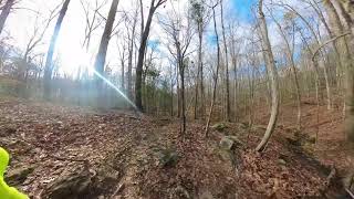
Probably one of the best pure mtb trails on the Dairy Ridge side of Croft. Lots to challenge any rider, the last grunt going counter clockwise from TC Trails is a small brute

This trail is unsanctioned.

Recent Activity on Trail

Past Week
  • 0 rides
  •  
6 Months
  • 9 rides
  • 8 miles avg distance
All
  • 135 rides
  • Last: May 31, 2026
c1c2c3c4
January
February
March
April
May
June
July
August
September
October
November
December
update trails status or condition

Chapters Trail Reports

statusdatedescription
Mar 13, 2025 @ 11:45am
Mar 13, 2025
Nov 8, 2023 @ 1:41am
Nov 8, 2023
Oct 26, 2023 @ 11:00am
Oct 26, 2023
Lots of leaves down but no slippage. This is a fun trail.
Oct 24, 2023 @ 10:36am
Oct 24, 2023
Rolling fun leaves now adding extra drift best of Croft
Sep 27, 2023 @ 8:56am
Sep 27, 2023
Trail in great condition
more »
Status:
on Mar 13, 2025
Dry
Avg: 4.13 (1 votes)
Your vote: 0

view (507)
close
3D
Trail Conditions
  • Unknown
  • Snow Groomed
  • Snow Packed
  • Snow Covered
  • Snow Cover Partial
  • Freeze/thaw Cycle
  • Icy
  • Prevalent Mud
  • Wet
  • Variable
  • Ideal
  • Dry
  • Very Dry
Trail Flow (Ridden Direction)
Trailforks scans users ridelogs to determine the most popular direction each trail is ridden. A good flowing trail network will have most trails flowing in a single direction according to their intension.
The colour categories are based on what percentage of riders are riding a trail in its intended direction.
  • > 96%
  • > 90%
  • > 80%
  • > 70%
  • > 50%
  • < 50%
  • bi-directional trail
  • no data
Trail Last Ridden
Trailforks scans ridelogs to determine the last time a trail was ridden.
  • < 2 days
  • < 1 week
  • < 2 weeks
  • < 1 month
  • < 6 months
  • > 6 months
Trail Ridden Direction
The intended direction a trail should be ridden.
  • Downhill Only
  • Downhill Primary
  • Both Directions
  • Uphill Primary
  • Uphill Only
  • One Direction
Contribute Details
Colors indicate trail is missing specified detail.
  • Description
  • Photos
  • Description & Photos
  • Videos
Trail Popularity ?
Trailforks scans ridelogs to determine which trails are ridden the most in the last 9 months. Trails are compared with nearby trails in the same city region with a possible 25 colour shades. Think of this as a heatmap, more rides = more kinetic energy = warmer colors.
  • most popular
  • popular
  • less popular
  • not popular
ATV/ORV/OHV Filter
Max Vehicle Width
inches
US Cell Coverage
Legend
cell carrier legend

Radar Time
Activity Recordings
Trailforks uses anonymized public activity data. ?
Activity Recordings
Trailforks uses anonymized public activity data. ?
Personal Heatmap
Activity Types
all / none
Options
2
Date range month
Winter Trails
Warning A routing network for winter maps does not exist. Selecting trails using the winter trails layer has been disabled.
Missing Trails
Most Popular
Least Popular
Trails are colored based on popularity. The more popular a trail is, the more red. Less popular trails trend towards green.
Jump Magnitude Heatmap
Heatmap of where riders jump on trails. Zoom in to see individual jumps, click circles to view jump details.
BC Backroad Status

Service Road Atlas is a free to use, community-driven service for viewing and creating reports on the numerous back-country service roads around B.C. and Alberta.

map legend
Slope Aspect
Direction the slope faces
Flat N NE E SE S SW W NW
Trails Deemphasized
Trails are shown in grey.
disable
Only show trails with no bike usage.
Enable
Suggested Layers
Based on selected activity type

    Save the current map location and zoom level as your default home location whenever this page is loaded.

    Save
        Directions to chapters trailhead (34.890320, -81.843070)

        Photos

        11 more »
        37 |
        Jul 30, 2024 @ 3:00pm
        Jul 30, 2024
        42 |
        Jul 30, 2024 @ 3:00pm
        Jul 30, 2024
        38 |
        Jul 30, 2024 @ 3:00pm
        Jul 30, 2024
        35 |
        Jul 26, 2024 @ 4:00pm
        Jul 26, 2024

        Videos

        1 more »
        Croft State Park - Kelsey Creek and Chapters -...
        143 | Mar 4, 2024 , Spartanburg

        Reviews / Comments

        No reviews yet, be the first to write a review or ask a question.
        Use trail reports to comment on trail conditions.


        We hope you've been enjoying Trailforks!

        Create a FREE account to view trail comments and much more.

        • #82676 - 1,519 views

        Frequently Asked Questions About Chapters

        Where is Chapters located?
        Chapters is located in Croft State Park, Spartanburg, South Carolina, United States. It is part of the Croft State Park trail network. The trailhead is located at coordinates 34.89032, -81.84307.
        How hard is Chapters?
        Chapters is rated as Blue difficulty. The physical rating is Moderate. The average grade is 0.7%. The climb difficulty is rated Blue.
        What is the elevation gain for Chapters?
        Chapters has 276 ft of elevation gain. The trail has 366 ft of elevation descent. The elevation ranges from 632 ft to 758 ft.
        Is Chapters a point to point trail?
        Chapters is not a point to point trail. The direction is Both Directions. The trail type is singletrack.

        Hit the Trail

        Open in App

        Get this trail on your phone instantly.
        open trail in app

        Download Trail

        Save to wishlist, Garmin & download.
        save the trail

        Find Related Routes

        Find routes and users activities that include this trail.
        find routes for this trail

        You must enter a description before submitting.