more stats
4,104 ft
Distance
-276 ft
Descent
00:02:51
Avg time
-276 ft
Altitude change
2,234 ft
Altitude min
2,510 ft
Altitude max
2,510 ft
Altitude start
2,234 ft
Altitude end
-6.7%
Grade
-25.2%
Grade max
3,484 ft
Distance down
623 ft
Distance flat
00:02:51
Avg time

Charter Details

  • Activities
    • Mountain Bike
  • Riding Area
    Sälen Bike Park
    Malung-Sälen
  • Difficulty Rating
  • Local Popularity
    95 in Mountain Biking
  • Global Ranking
    #33405 in Mountain Biking
  • Trail Type
    Machine Groomed
  • Bike Type
    DH, AM
  • Direction
    Downhill Only
    Popular Direction Shown
  • Physical Rating
    Moderate
  • Dogs Allowed
    Yes
  • TTFs on Trail
    Berm, Bridge, Jump, Gap Jump, Ladder Bridge, Wallride

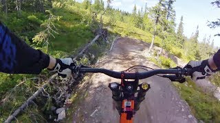
Ledenär för de åkare som vill höja fart och insats från Pipeline och Rosa Leden. Leden är röd och kräver således mer av åkaren. Grunden i banan är fart, hopp och flow. Vi har tagit hjälp med designen av Tom Pro från Gravity Logic som bl.a. har designat banorna i Whistler Bike Park. Leden börjar tillsammans med Herr Melin och går av och blir röd innan Herr Melin möter Rosa Leden.

Bike Park

Traditionally Indigenous Territory

Recent Activity on Trail

Past Week
  • 0 rides
  •  
6 Months
  • 0 rides
  •  
All
  • 101 rides
  • Last: Jun 21, 2026
c1c2c3c4
January
February
March
April
May
June
July
August
September
October
November
December
Status:
on Aug 11, 2025
Ideal
Avg: 4.39 (11 votes)
Your vote: 0

view (2,474)
close
3D
Trail Conditions
  • Unknown
  • Snow Groomed
  • Snow Packed
  • Snow Covered
  • Snow Cover Partial
  • Freeze/thaw Cycle
  • Icy
  • Prevalent Mud
  • Wet
  • Variable
  • Ideal
  • Dry
  • Very Dry
Trail Flow (Ridden Direction)
Trailforks scans users ridelogs to determine the most popular direction each trail is ridden. A good flowing trail network will have most trails flowing in a single direction according to their intension.
The colour categories are based on what percentage of riders are riding a trail in its intended direction.
  • > 96%
  • > 90%
  • > 80%
  • > 70%
  • > 50%
  • < 50%
  • bi-directional trail
  • no data
Trail Last Ridden
Trailforks scans ridelogs to determine the last time a trail was ridden.
  • < 2 days
  • < 1 week
  • < 2 weeks
  • < 1 month
  • < 6 months
  • > 6 months
Trail Ridden Direction
The intended direction a trail should be ridden.
  • Downhill Only
  • Downhill Primary
  • Both Directions
  • Uphill Primary
  • Uphill Only
  • One Direction
Contribute Details
Colors indicate trail is missing specified detail.
  • Description
  • Photos
  • Description & Photos
  • Videos
Trail Popularity ?
Trailforks scans ridelogs to determine which trails are ridden the most in the last 9 months. Trails are compared with nearby trails in the same city region with a possible 25 colour shades. Think of this as a heatmap, more rides = more kinetic energy = warmer colors.
  • most popular
  • popular
  • less popular
  • not popular
ATV/ORV/OHV Filter
Max Vehicle Width
inches
US Cell Coverage
Legend
cell carrier legend

Radar Time
Activity Recordings
Trailforks uses anonymized public activity data. ?
Activity Recordings
Trailforks uses anonymized public activity data. ?
Personal Heatmap
Activity Types
all / none
Options
2
Date range month
Winter Trails
Warning A routing network for winter maps does not exist. Selecting trails using the winter trails layer has been disabled.
Missing Trails
Most Popular
Least Popular
Trails are colored based on popularity. The more popular a trail is, the more red. Less popular trails trend towards green.
Jump Magnitude Heatmap
Heatmap of where riders jump on trails. Zoom in to see individual jumps, click circles to view jump details.
BC Backroad Status

Service Road Atlas is a free to use, community-driven service for viewing and creating reports on the numerous back-country service roads around B.C. and Alberta.

map legend
Slope Aspect
Direction the slope faces
Flat N NE E SE S SW W NW
Trails Deemphasized
Trails are shown in grey.
disable
Only show trails with no bike usage.
Enable
Suggested Layers
Based on selected activity type

    Save the current map location and zoom level as your default home location whenever this page is loaded.

    Save
        Directions to charter trailhead (61.157140, 13.170960)

        Photos

        No photos have been added for Charter yet, add a photo.

        Videos

        5 more »
        youtuber Party Laps on a Trail Bike in Sälen Bike Park
        2:51 | 208 | Aug 16, 2023 , Malung-Sälen
        MTB run Charter Lindvallen july 2021
        2:32 | 448 | Jul 11, 2021 , Malung-Sälen
        Sälen BikePark - Charter full run
        561 | Nov 1, 2017 , Malung-Sälen
        youtuber MTB Downhill in Sälen Bike Park - Day 4,...
        516 | Nov 12, 2016 , Malung-Sälen

        Reviews / Comments

        No reviews yet, be the first to write a review or ask a question.
        Use trail reports to comment on trail conditions.


        We hope you've been enjoying Trailforks!

        Create a FREE account to view trail comments and much more.

        • By maciek1998TF Pro & contributors
        • #55543 - 1,733 views

        Frequently Asked Questions About Charter

        Where is Charter located?
        Charter is located in Sälen Bike Park, Malung-Sälen, Sweden. It is part of the Sälen Bike Park trail network. The trailhead is located at coordinates 61.15714, 13.17096.
        How hard is Charter?
        Charter is rated as Red difficulty. The physical rating is Moderate. The average grade is 6.7%.
        What is the elevation gain for Charter?
        The trail has 276 ft of elevation descent. The elevation ranges from 2,234 ft to 2,510 ft.
        Is Charter a point to point trail?
        Yes, Charter is a point to point trail. The direction is Downhill Only. The trail type is machine groomed.

        Hit the Trail

        Open in App

        Get this trail on your phone instantly.
        open trail in app

        Download Trail

        Save to wishlist, Garmin & download.
        save the trail

        Find Related Routes

        Find routes and users activities that include this trail.
        find routes for this trail

        You must enter a description before submitting.