more stats
1.2 miles
Distance
31 ft
Climb
-1,033 ft
Descent
00:23:05
Avg time
-1,002 ft
Altitude change
2,936 ft
Altitude min
3,963 ft
Altitude max
3,938 ft
Altitude start
2,936 ft
Altitude end
-16.1%
Grade
-90.1%
Grade max
21.4%
Grade min
364 ft
Distance climb
1 mile
Distance down
377 ft
Distance flat
00:23:05
Avg time

Cherry Poppins Details

  • Activities
    • Mountain Bike
    • E-Bike
    • Hike
    • Trail Running
  • Riding Area
    Malde Creek
    Rossland, British Columbia
  • Difficulty Rating
  • Local Popularity
    50 in Mountain Biking [+]
    • 50 in E-Biking
    • 5 in Trail Running
    • 5 in Hiking
  • Global Ranking
    #78402 in Mountain Biking [+]
    • #62580 in E-Biking
    • #129024 in Trail Running
    • #122018 in Hiking
  • Trail Type
    Singletrack
  • Bike Type
    DH, AM
  • Direction
    Downhill Only
    Popular Direction Shown
  • Physical Rating
    Moderate
  • Season
    June - October
  • Dogs Allowed
    Yes
  • eBike Allowed
    Yes up to Class 1
  • TTFs on Trail
    Bridge, Drop, Jump, Gap Jump, Ladder Bridge, Rock Face, Skinny

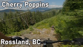
Built in 2006, Cherry Poppins is still one of the rowdiest freeride trails around. Some great elevated features and big drops. Look before you leap on this trail It gets buck-wild steep in the last third too. Access it via Drake's / Doukhobor / Tamarack for a truly "BCXC" experience.

Local Trail Association

Recent Activity on Trail

Past Week
  • 0 rides
  •  
6 Months
  • 1 rides
  • 10 miles avg distance
All
  • 71 rides
  • Last: Jul 31, 2016
c1c2c3c4
January
February
March
April
May
June
July
August
September
October
November
December
update trails status or condition

Cherry Poppins Trail Reports

statusdatedescription
May 19, 2026 @ 8:11am (America/Vancouver)
May 19, 2026
reporter The KCTS trail crew has done an initial pass and cleared a ton of trees, but there is still major trail damage from blown down trees, and the...
Aug 14, 2025 @ 6:21pm
Aug 14, 2025
2 trees down in the mid flow section
Jul 26, 2025 @ 4:42pm
Jul 26, 2025
Jul 16, 2025 @ 7:10pm
Jul 16, 2025
Pretty sizable tree down. It will need a chainsaw probably. Good sight line on it when riding!
May 31, 2025 @ 1:12pm
May 31, 2025
12” diameter tree down across trail after the long skinny below the Cherry Bomb drop.
more »
Status:
on May 19, 2026
Ideal
Avg: 4.04 (16 votes)
Your vote: 0

view (689)
close
3D
Trail Conditions
  • Unknown
  • Snow Groomed
  • Snow Packed
  • Snow Covered
  • Snow Cover Partial
  • Freeze/thaw Cycle
  • Icy
  • Prevalent Mud
  • Wet
  • Variable
  • Ideal
  • Dry
  • Very Dry
Trail Flow (Ridden Direction)
Trailforks scans users ridelogs to determine the most popular direction each trail is ridden. A good flowing trail network will have most trails flowing in a single direction according to their intension.
The colour categories are based on what percentage of riders are riding a trail in its intended direction.
  • > 96%
  • > 90%
  • > 80%
  • > 70%
  • > 50%
  • < 50%
  • bi-directional trail
  • no data
Trail Last Ridden
Trailforks scans ridelogs to determine the last time a trail was ridden.
  • < 2 days
  • < 1 week
  • < 2 weeks
  • < 1 month
  • < 6 months
  • > 6 months
Trail Ridden Direction
The intended direction a trail should be ridden.
  • Downhill Only
  • Downhill Primary
  • Both Directions
  • Uphill Primary
  • Uphill Only
  • One Direction
Contribute Details
Colors indicate trail is missing specified detail.
  • Description
  • Photos
  • Description & Photos
  • Videos
Trail Popularity ?
Trailforks scans ridelogs to determine which trails are ridden the most in the last 9 months. Trails are compared with nearby trails in the same city region with a possible 25 colour shades. Think of this as a heatmap, more rides = more kinetic energy = warmer colors.
  • most popular
  • popular
  • less popular
  • not popular
ATV/ORV/OHV Filter
Max Vehicle Width
inches
US Cell Coverage
Legend
cell carrier legend

Radar Time
Activity Recordings
Trailforks uses anonymized public activity data. ?
Activity Recordings
Trailforks uses anonymized public activity data. ?
Personal Heatmap
Activity Types
all / none
Options
2
Date range month
Winter Trails
Warning A routing network for winter maps does not exist. Selecting trails using the winter trails layer has been disabled.
Missing Trails
Most Popular
Least Popular
Trails are colored based on popularity. The more popular a trail is, the more red. Less popular trails trend towards green.
Jump Magnitude Heatmap
Heatmap of where riders jump on trails. Zoom in to see individual jumps, click circles to view jump details.
BC Backroad Status

Service Road Atlas is a free to use, community-driven service for viewing and creating reports on the numerous back-country service roads around B.C. and Alberta.

map legend
Slope Aspect
Direction the slope faces
Flat N NE E SE S SW W NW
Trails Deemphasized
Trails are shown in grey.
disable
Only show trails with no bike usage.
Enable
Suggested Layers
Based on selected activity type

    Save the current map location and zoom level as your default home location whenever this page is loaded.

    Save
        Directions to cherry-poppins trailhead (49.049680, -117.782690)

        Photos

        29 more »
        245 |
        Jun 28, 2022 @ 8:33pm
        Jun 28, 2022
        353 |
        Jun 28, 2022 @ 8:33pm
        Jun 28, 2022
        419 |
        Oct 19, 2018 @ 8:02pm
        Oct 19, 2018
        629 |
        Aug 1, 2016 @ 10:30am
        Aug 1, 2016

        Videos

        2 more »
        youtuber Classic Rossland Tech// Cherry Poppins -...
        9:15 | 601 | Jul 10, 2023 , Rossland
        Back to Speed with Bodhi Kuhn
        0:43 | 7028 | Dec 22, 2019 , Rossland

        Routes with this trail

        22 miles 4,588 ft 8 Loop
        A selection of the finest trails off and Malde FSR. Add for a truly spectacular loop.
        28 miles 6,577 ft 13
        3.0 63 miles 14,086 ft 43 Loop
        Big loop comprising of most of the iconic trails in the Rossland area.

        Links

        8 Reviews & Comments


        We hope you've been enjoying Trailforks!

        Create a FREE account to view trail comments and much more.

        • By canadakaTF Pro Trailforks & contributors
        • #2162 - 7,470 views

        Frequently Asked Questions About Cherry Poppins

        Where is Cherry Poppins located?
        Cherry Poppins is located in Malde Creek, Rossland, British Columbia, Canada. It is part of the Malde Creek trail network. The trailhead is located at coordinates 49.04968, -117.78269.
        How hard is Cherry Poppins?
        Cherry Poppins is rated as Double Black Diamond difficulty. The physical rating is Moderate. The average grade is 16.1%.
        What is the elevation gain for Cherry Poppins?
        Cherry Poppins has 31 ft of elevation gain. The trail has 1,033 ft of elevation descent. The elevation ranges from 2,936 ft to 3,963 ft.
        Is Cherry Poppins a point to point trail?
        Yes, Cherry Poppins is a point to point trail. The direction is Downhill Only. The trail type is singletrack.

        Hit the Trail

        Open in App

        Get this trail on your phone instantly.
        open trail in app

        Download Trail

        Save to wishlist, Garmin & download.
        save the trail

        Find Related Routes

        Find routes and users activities that include this trail.
        find routes for this trail

        You must enter a description before submitting.