more stats
2.0 miles
Distance
385 ft
Climb
-13 ft
Descent
00:12:43
Avg time
370 ft
Altitude change
7,021 ft
Altitude min
7,394 ft
Altitude max
7,021 ft
Altitude start
7,392 ft
Altitude end
3.5%
Grade
-8%
Grade max
17%
Grade min
1 mile
Distance climb
827 ft
Distance down
3,678 ft
Distance flat
00:12:43
Avg time

Chicken Dinner Details

  • Activities
    • Mountain Bike
    • Hike
    • Trail Running
  • Riding Area
    Arkansas Hills Trails
    Salida, Colorado
  • Difficulty Rating
  • Local Popularity
    95 in Mountain Biking [+]
    • 75 in Trail Running
    • 80 in Hiking
  • Global Ranking
    #27801 in Mountain Biking [+]
    • #44682 in Trail Running
    • #48223 in Hiking
  • Trail Type
    Singletrack
  • Bike Type
    AM, XC
  • Climb Difficulty
    Blue
  • Physical Rating
    Moderate
  • Dogs Allowed
    Yes
  • eBike Allowed
  • TTFs on Trail
    Berm, Jump, Rock Garden
  • Year Opened
    2016
  • Land Owner

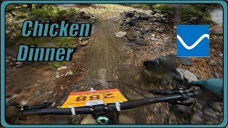
The newest additions to the Arkansas Hills Trail System Chicken Dinner was completed in December of 2016. Spicy XC trail, fun on the way down (mostly down, has some pedally bits), pretty easy on the way up.

Trail Supporters
Local Trail Association
Traditionally Indigenous Territory

Recent Activity on Trail

Past Week
  • 5 rides
  • 18 miles average
6 Months
  • 56 rides
  • 15 miles avg distance
All
  • 589 rides
  • Last: Jun 16, 2026
c1c2c3c4
January
February
March
April
May
June
July
August
September
October
November
December
update trails status or condition

Chicken Dinner Trail Reports

Status:
on Jun 5, 2026
Ideal
Avg: 3.91 (28 votes)
Your vote: 0

view (3,813)
close
3D
Trail Conditions
  • Unknown
  • Snow Groomed
  • Snow Packed
  • Snow Covered
  • Snow Cover Partial
  • Freeze/thaw Cycle
  • Icy
  • Prevalent Mud
  • Wet
  • Variable
  • Ideal
  • Dry
  • Very Dry
Trail Flow (Ridden Direction)
Trailforks scans users ridelogs to determine the most popular direction each trail is ridden. A good flowing trail network will have most trails flowing in a single direction according to their intension.
The colour categories are based on what percentage of riders are riding a trail in its intended direction.
  • > 96%
  • > 90%
  • > 80%
  • > 70%
  • > 50%
  • < 50%
  • bi-directional trail
  • no data
Trail Last Ridden
Trailforks scans ridelogs to determine the last time a trail was ridden.
  • < 2 days
  • < 1 week
  • < 2 weeks
  • < 1 month
  • < 6 months
  • > 6 months
Trail Ridden Direction
The intended direction a trail should be ridden.
  • Downhill Only
  • Downhill Primary
  • Both Directions
  • Uphill Primary
  • Uphill Only
  • One Direction
Contribute Details
Colors indicate trail is missing specified detail.
  • Description
  • Photos
  • Description & Photos
  • Videos
Trail Popularity ?
Trailforks scans ridelogs to determine which trails are ridden the most in the last 9 months. Trails are compared with nearby trails in the same city region with a possible 25 colour shades. Think of this as a heatmap, more rides = more kinetic energy = warmer colors.
  • most popular
  • popular
  • less popular
  • not popular
ATV/ORV/OHV Filter
Max Vehicle Width
inches
US Cell Coverage
Legend
cell carrier legend

Radar Time
Activity Recordings
Trailforks uses anonymized public activity data. ?
Activity Recordings
Trailforks uses anonymized public activity data. ?
Personal Heatmap
Activity Types
all / none
Options
2
Date range month
Winter Trails
Warning A routing network for winter maps does not exist. Selecting trails using the winter trails layer has been disabled.
Missing Trails
Most Popular
Least Popular
Trails are colored based on popularity. The more popular a trail is, the more red. Less popular trails trend towards green.
Jump Magnitude Heatmap
Heatmap of where riders jump on trails. Zoom in to see individual jumps, click circles to view jump details.
BC Backroad Status

Service Road Atlas is a free to use, community-driven service for viewing and creating reports on the numerous back-country service roads around B.C. and Alberta.

map legend
Slope Aspect
Direction the slope faces
Flat N NE E SE S SW W NW
Trails Deemphasized
Trails are shown in grey.
disable
Only show trails with no bike usage.
Enable
Suggested Layers
Based on selected activity type

    Save the current map location and zoom level as your default home location whenever this page is loaded.

    Save
        Directions to chicken-dinner trailhead (38.519600, -105.975260)

        Photos

        6 more »
        70 |
        May 21, 2025 @ 11:08am
        May 21, 2025
        319 |
        Jan 9, 2019 @ 12:16pm
        Jan 9, 2019
        490 |
        Dec 27, 2016 @ 5:06pm
        Dec 27, 2016
        527 |
        Dec 27, 2016 @ 5:05pm
        Dec 27, 2016

        Videos

        2 more »
        youtuber Winner, Winner, Chicken Dinner! MTB Salida |...
        13:41 | 695 | Oct 8, 2019 , Salida
        Chicken Dinner | Salida Enduro Stage 5
        9:56 | 167 | Jun 2, 2024 , Salida

        Routes with this trail

        Cottonwood Tour Featured
        3.7 22 miles 2,663 ft 14 Loop
        This route connects some of the best trails around Salida in the S mountain area. Some connectors are not...
        5.0 22 miles 2,943 ft 13 Loop
        The Cottonwood Tour but with The Dude Abides detour joining up to North Backbone instead of the full North...
        10 miles 968 ft 6
        S Mountain Chicken for Dinner RECOMMENDED ROUTE

        9 Reviews & Comments


        We hope you've been enjoying Trailforks!

        Create a FREE account to view trail comments and much more.

        • By trailforksTF Pro Trailforks & contributors
        • #78742 - 3,723 views

        Frequently Asked Questions About Chicken Dinner

        Where is Chicken Dinner located?
        Chicken Dinner is located in Arkansas Hills Trails, Salida, Colorado, United States. It is part of the Arkansas Hills Trails trail network. The trailhead is located at coordinates 38.5196, -105.97526.
        How hard is Chicken Dinner?
        Chicken Dinner is rated as Blue difficulty. The physical rating is Moderate. The average grade is 3.5%. The climb difficulty is rated Blue.
        What is the elevation gain for Chicken Dinner?
        Chicken Dinner has 118 m of elevation gain. The trail has 4 m of elevation descent. The elevation ranges from 2,140 m to 2,254 m.
        How long is Chicken Dinner?
        Chicken Dinner is 3.3 km long. The trail type is singletrack.

        Hit the Trail

        Open in App

        Get this trail on your phone instantly.
        open trail in app

        Download Trail

        Save to wishlist, Garmin & download.
        save the trail

        Find Related Routes

        Find routes and users activities that include this trail.
        find routes for this trail

        You must enter a description before submitting.