more stats
4,298 ft
Distance
-545 ft
Descent
00:12:47
Avg time
-545 ft
Altitude change
3,822 ft
Altitude min
4,367 ft
Altitude max
4,367 ft
Altitude start
3,822 ft
Altitude end
-12.7%
Grade
-34.5%
Grade max
4,226 ft
Distance down
72 ft
Distance flat
00:12:47
Avg time

Chill Trail Details

  • Activities
    • Mountain Bike
    • E-Bike
  • Riding Area
  • Difficulty Rating
  • Local Popularity
    60 in Mountain Biking [+]
    • 20 in E-Biking
  • Global Ranking
    #24308 in Mountain Biking [+]
    • #101493 in E-Biking
  • Trail Type
    Singletrack
  • Direction
    Downhill Only
    Popular Direction Shown

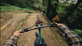
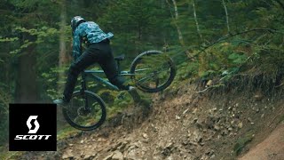
"Chill Trail" is a new concept created by the partnership of Bike Vision, a trail building company, and Vinny T, pro rider. The main goal of the Chill Trail is to combine the vision of an athlete and the know-how of a Trail Building company. The challenge is to associate the desires of a high level athlete and the integration of these wishes in a Bikepark.

The first Chill Trail was born and inaugurated this year in France in the Bike Park of Bernex Vinny T selected a few friends and fellow riders to try out this new concept on the day of the inauguration.

We would like to thank BlueGrass protection for supporting us on this first Chill Trail!

Recent Activity on Trail

Past Week
  • 0 rides
  •  
6 Months
  • 0 rides
  •  
All
  • 19 rides
  • Last: Aug 4, 2025
c1c2c3c4
January
February
March
April
May
June
July
August
September
October
November
December
update trails status or condition

Chill Trail Trail Reports

no reports have been added for Chill Trail yet, add a trail report.
Trail reports are used to indicate a trails current condition and inform builders and other riders about any issues on a trail.
Status:
Avg: 4.13 (1 votes)
Your vote: 0

view (174)
close
3D
Trail Conditions
  • Unknown
  • Snow Groomed
  • Snow Packed
  • Snow Covered
  • Snow Cover Partial
  • Freeze/thaw Cycle
  • Icy
  • Prevalent Mud
  • Wet
  • Variable
  • Ideal
  • Dry
  • Very Dry
Trail Flow (Ridden Direction)
Trailforks scans users ridelogs to determine the most popular direction each trail is ridden. A good flowing trail network will have most trails flowing in a single direction according to their intension.
The colour categories are based on what percentage of riders are riding a trail in its intended direction.
  • > 96%
  • > 90%
  • > 80%
  • > 70%
  • > 50%
  • < 50%
  • bi-directional trail
  • no data
Trail Last Ridden
Trailforks scans ridelogs to determine the last time a trail was ridden.
  • < 2 days
  • < 1 week
  • < 2 weeks
  • < 1 month
  • < 6 months
  • > 6 months
Trail Ridden Direction
The intended direction a trail should be ridden.
  • Downhill Only
  • Downhill Primary
  • Both Directions
  • Uphill Primary
  • Uphill Only
  • One Direction
Contribute Details
Colors indicate trail is missing specified detail.
  • Description
  • Photos
  • Description & Photos
  • Videos
Trail Popularity ?
Trailforks scans ridelogs to determine which trails are ridden the most in the last 9 months. Trails are compared with nearby trails in the same city region with a possible 25 colour shades. Think of this as a heatmap, more rides = more kinetic energy = warmer colors.
  • most popular
  • popular
  • less popular
  • not popular
ATV/ORV/OHV Filter
Max Vehicle Width
inches
US Cell Coverage
Legend
cell carrier legend

Radar Time
Activity Recordings
Trailforks uses anonymized public activity data. ?
Activity Recordings
Trailforks uses anonymized public activity data. ?
Personal Heatmap
Activity Types
all / none
Options
2
Date range month
Winter Trails
Warning A routing network for winter maps does not exist. Selecting trails using the winter trails layer has been disabled.
Missing Trails
Most Popular
Least Popular
Trails are colored based on popularity. The more popular a trail is, the more red. Less popular trails trend towards green.
Jump Magnitude Heatmap
Heatmap of where riders jump on trails. Zoom in to see individual jumps, click circles to view jump details.
BC Backroad Status

Service Road Atlas is a free to use, community-driven service for viewing and creating reports on the numerous back-country service roads around B.C. and Alberta.

map legend
Slope Aspect
Direction the slope faces
Flat N NE E SE S SW W NW
Trails Deemphasized
Trails are shown in grey.
disable
Only show trails with no bike usage.
Enable
Suggested Layers
Based on selected activity type

    Save the current map location and zoom level as your default home location whenever this page is loaded.

    Save
        Directions to chill-trail trailhead (46.346300, 6.699120)

        Photos

        10 more »
        276 |
        Mar 3, 2023 @ 12:11am
        Mar 3, 2023
        308 |
        Mar 3, 2023 @ 12:11am
        Mar 3, 2023
        337 |
        Mar 3, 2023 @ 12:11am
        Mar 3, 2023
        403 |
        Mar 3, 2023 @ 12:11am
        Mar 3, 2023

        Videos

        3 more »
        youtuber Bernex Bikepark GoPro Raw
        10:39 | 99 | Aug 26, 2024 , Bernex
        MUST WATCH - 'The Chill Trail' with Vinny T
        3:16 | 288 | Nov 10, 2022 , Bernex
        Chill Trail by Vinny T & Bikevision
        0:45 | 206 | Jul 26, 2022 , Bernex

        Articles

        Video: Vinny T Builds & Rides 'Chill Trail' - A New Jump Line
        Jul 23, 2022 from pinkbike.com
        The new trail in the Bike Park of Bernex looks worthy of Vinny T.

        Reviews / Comments

        No reviews yet, be the first to write a review or ask a question.
        Use trail reports to comment on trail conditions.


        We hope you've been enjoying Trailforks!

        Create a FREE account to view trail comments and much more.

        Nearby Trails

        • By toddTF Pro Trailforks & contributors
        • #554860 - 1,302 views

        Frequently Asked Questions About Chill Trail

        Where is Chill Trail located?
        Chill Trail is located in Bernex Bikepark, Bernex, France. It is part of the Bernex Bikepark trail network. The trailhead is located at coordinates 46.3463, 6.69912.
        How hard is Chill Trail?
        Chill Trail is rated as Proline difficulty. The average grade is 12.7%.
        What is the elevation gain for Chill Trail?
        The trail has 166 m of elevation descent. The elevation ranges from 1,165 m to 1,331 m.
        Is Chill Trail a point to point trail?
        Yes, Chill Trail is a point to point trail. The direction is Downhill Only. The trail type is singletrack.

        Hit the Trail

        Open in App

        Get this trail on your phone instantly.
        open trail in app

        Download Trail

        Save to wishlist, Garmin & download.
        save the trail

        Find Related Routes

        Find routes and users activities that include this trail.
        find routes for this trail

        You must enter a description before submitting.