more stats
6.6 miles
Distance
553 ft
Climb
-631 ft
Descent
00:48:52
Avg time
-79 ft
Altitude change
408 ft
Altitude min
790 ft
Altitude max
609 ft
Altitude start
531 ft
Altitude end
-0.2%
Grade
-33%
Grade max
34.2%
Grade min
2 miles
Distance climb
3 miles
Distance down
1 mile
Distance flat
00:48:52
Avg time

Chubb Trail Details

  • Activities
    • Mountain Bike
    • Hike
    • Trail Running
  • Riding Area
    West Tyson County Park
    St. Louis, Missouri
  • Difficulty Rating
  • Local Popularity
    50 in Mountain Biking [+]
    • 60 in Trail Running
    • 80 in Hiking
  • Global Ranking
    #41873 in Mountain Biking [+]
    • #80592 in Trail Running
    • #52581 in Hiking
  • Trail Type
    Singletrack
  • Bike Type
    DH, XC
  • Direction
    Both Directions
    Popular In Reverse
  • Climb Difficulty
    Black Diamond
  • Physical Rating
    Hard
  • Season
    Year round
  • Dogs Allowed
    Yes
  • TTFs on Trail
    Drop
  • Land Owner

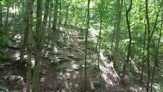
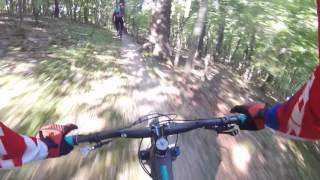
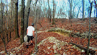
The Chubb begins at the Circle at the top of the road to the left as you enter the park, and Flint Quarry at the parking lot at the end of the lower entrance. There is a 0.3 mile connector between the 2 trailheads. Both trails come together at the Picnic Table, around 1.5 miles into either trail. The Chubb continues on down to the Meramec River bottom while the Flint Quarry makes use of part of the Chubb, and the trail formerly known as the Ridge Trail, making its way back to its starting point for a 3 mile loop. Both trails at this end offer many opportunities to test your skills with steep climbs, loose rocks, drop-offs, and tight switchbacks. This section of the Chubb contains "the Steps", an exposed section of the Kimmswick Limestone, which is sure to challenge your technical ability. The eastern end is mainly dirt singletrack with a moderately steep climb that ends at the trailhead in Lone Elk County Park.

source: Chubb Trail
Local Trail Association

Recent Activity on Trail

Past Week
  • 0 rides
  •  
6 Months
  • 1 rides
  • 17 miles avg distance
All
  • 24 rides
  • Last: Apr 9, 2026
c1c2c3c4
January
February
March
April
May
June
July
August
September
October
November
December
Status:
on Mar 27, 2025
Variable
Avg: 4.29 (11 votes)
Your vote: 0

view (358)
close
3D
Trail Conditions
  • Unknown
  • Snow Groomed
  • Snow Packed
  • Snow Covered
  • Snow Cover Partial
  • Freeze/thaw Cycle
  • Icy
  • Prevalent Mud
  • Wet
  • Variable
  • Ideal
  • Dry
  • Very Dry
Trail Flow (Ridden Direction)
Trailforks scans users ridelogs to determine the most popular direction each trail is ridden. A good flowing trail network will have most trails flowing in a single direction according to their intension.
The colour categories are based on what percentage of riders are riding a trail in its intended direction.
  • > 96%
  • > 90%
  • > 80%
  • > 70%
  • > 50%
  • < 50%
  • bi-directional trail
  • no data
Trail Last Ridden
Trailforks scans ridelogs to determine the last time a trail was ridden.
  • < 2 days
  • < 1 week
  • < 2 weeks
  • < 1 month
  • < 6 months
  • > 6 months
Trail Ridden Direction
The intended direction a trail should be ridden.
  • Downhill Only
  • Downhill Primary
  • Both Directions
  • Uphill Primary
  • Uphill Only
  • One Direction
Contribute Details
Colors indicate trail is missing specified detail.
  • Description
  • Photos
  • Description & Photos
  • Videos
Trail Popularity ?
Trailforks scans ridelogs to determine which trails are ridden the most in the last 9 months. Trails are compared with nearby trails in the same city region with a possible 25 colour shades. Think of this as a heatmap, more rides = more kinetic energy = warmer colors.
  • most popular
  • popular
  • less popular
  • not popular
ATV/ORV/OHV Filter
Max Vehicle Width
inches
US Cell Coverage
Legend
cell carrier legend

Radar Time
Activity Recordings
Trailforks uses anonymized public activity data. ?
Activity Recordings
Trailforks uses anonymized public activity data. ?
Personal Heatmap
Activity Types
all / none
Options
2
Date range month
Winter Trails
Warning A routing network for winter maps does not exist. Selecting trails using the winter trails layer has been disabled.
Missing Trails
Most Popular
Least Popular
Trails are colored based on popularity. The more popular a trail is, the more red. Less popular trails trend towards green.
Jump Magnitude Heatmap
Heatmap of where riders jump on trails. Zoom in to see individual jumps, click circles to view jump details.
BC Backroad Status

Service Road Atlas is a free to use, community-driven service for viewing and creating reports on the numerous back-country service roads around B.C. and Alberta.

map legend
Slope Aspect
Direction the slope faces
Flat N NE E SE S SW W NW
Trails Deemphasized
Trails are shown in grey.
disable
Only show trails with no bike usage.
Enable
Suggested Layers
Based on selected activity type

    Save the current map location and zoom level as your default home location whenever this page is loaded.

    Save
        Directions to chubb-trail trailhead (38.536810, -90.538010)

        Photos

        20 more »
        144 |
        Jul 12, 2022 @ 12:31pm
        Jul 12, 2022
        248 |
        Mar 30, 2021 @ 8:34pm
        Mar 30, 2021
        250 |
        Mar 25, 2021 @ 1:18pm
        Mar 25, 2021
        285 |
        Mar 25, 2021 @ 1:18pm
        Mar 25, 2021

        Videos

        4 more »
        Deana's Chubb Run - stuck at 99%
        1243 | Aug 13, 2017 , St. Louis
        Chubb Trail
        1982 | Jun 13, 2016 , St. Louis
        Chubb Trail, West Tyson park.
        0:46 | 541 | Nov 16, 2012 , St. Louis
        Andrew Chubb Drop
        0:17 | 505 | Jan 13, 2008 , St. Louis

        4 Reviews & Comments


        We hope you've been enjoying Trailforks!

        Create a FREE account to view trail comments and much more.

        • By pilznrTF Pro GORC & contributors
        • #36721 - 7,352 views

        Frequently Asked Questions About Chubb Trail

        Where is Chubb Trail located?
        Chubb Trail is located in West Tyson County Park, St. Louis, Missouri, United States. It is part of the West Tyson County Park trail network. The trailhead is located at coordinates 38.53681, -90.53801.
        How hard is Chubb Trail?
        Chubb Trail is rated as Black Diamond difficulty. The physical rating is Hard. The average grade is 0.2%. The climb difficulty is rated Black Diamond.
        What is the elevation gain for Chubb Trail?
        Chubb Trail has 553 ft of elevation gain. The trail has 631 ft of elevation descent. The elevation ranges from 408 ft to 790 ft.
        Is Chubb Trail a point to point trail?
        Chubb Trail is not a point to point trail. The direction is Both Directions. The trail type is singletrack.

        Hit the Trail

        Open in App

        Get this trail on your phone instantly.
        open trail in app

        Download Trail

        Save to wishlist, Garmin & download.
        save the trail

        Find Related Routes

        Find routes and users activities that include this trail.
        find routes for this trail

        You must enter a description before submitting.